


 Extract (6-MSITC) in Healthy Older Adults")
: An In-Depth Exploration into its Thermogenic Role and Social Significance")


On March 04, 2025, the global scientific community stands witness to a transformative milestone in optical imaging technology, driven by a team of Chinese scientists from the Aerospace Information Research Institute of the Chinese Academy of Sciences. Their development of a synthetic aperture lidar (SAL) system, capable of capturing millimeter-level resolution images from distances exceeding 100 kilometers, marks an unprecedented leap forward, surpassing the capabilities of existing imaging technologies by a factor of 100. This breakthrough, rigorously tested across the expansive Qinghai Lake in northwest China, not only redefines the boundaries of long-range observation but also positions China at the forefront of a technological race with profound implications for surveillance, defense, and space research. Through a meticulous integration of advanced laser systems, adaptive algorithms, and innovative optical engineering, this achievement transcends traditional limitations, offering a glimpse into a future where the minutiae of distant objects—be they terrestrial or extraterrestrial—can be discerned with astonishing clarity.
The origins of this technological marvel trace back to a carefully orchestrated experiment conducted in 2024 at Qinghai Lake, a high-altitude body of water spanning approximately 4,500 square kilometers, renowned for its pristine atmospheric conditions. Positioned on the lake’s northern shore, the research team deployed their SAL system to image reflective prism arrays situated 101.8 kilometers away—an extraordinary distance that challenges the foundational constraints of optical physics. Under optimal conditions, characterized by visibility exceeding 30 kilometers, minimal cloud cover, and wind speeds below 5 meters per second, the system achieved a resolution of 1.7 millimeters in range and an accuracy of 15.6 millimeters in distance measurement. These metrics, published in the peer-reviewed Chinese Journal of Lasers in 2024, signify a paradigm shift, rendering conventional imaging systems—such as high-altitude reconnaissance cameras and ground-based telescopes—comparatively obsolete.
At the heart of this innovation lies the synthetic aperture lidar system, a laser-based technology that adapts principles from microwave synthetic aperture radar (SAR) to the optical domain. Unlike traditional SAR, which operates at wavelengths of centimeters to meters and yields resolutions on the order of decimeters, SAL leverages the shorter wavelengths of light—typically in the nanometer range—to achieve resolutions at the millimeter scale. The system’s optical aperture, expanded from 17.2 millimeters to 68.8 millimeters through a 4×4 micro-lens array, amplifies its capacity to collect and focus light from distant targets. This enhancement, coupled with a 103-watt laser emitting chirped signals at a bandwidth exceeding 10 gigahertz, enables the system to resolve fine details across both range (vertical depth) and azimuth (horizontal span). The result is an imaging capability that can theoretically distinguish features as small as a coin from over 100 kilometers away—a feat unimaginable with prior technologies.
The technical sophistication of this system extends beyond its hardware. Adaptive algorithms, designed to suppress optical noise by a factor of 10,000, play a pivotal role in its success. Optical noise, arising from atmospheric scattering, thermal fluctuations, and photon shot noise, has historically degraded the quality of long-range laser imaging. By employing real-time digital signal processing, the team filtered out these disturbances, ensuring that faint return signals from targets over 100 kilometers away remained discernible. This noise reduction, combined with the laser’s narrow spectral linewidth—maintaining a color range within a few nanometers—enhances the system’s azimuth resolution, allowing it to differentiate horizontal features with unprecedented sharpness. During the Qinghai Lake trials, this capability was demonstrated through the imaging of prism arrays, where the system resolved patterns with a clarity that surpassed even the most advanced spy satellites currently in operation.
To contextualize this achievement, consider the benchmarks set by previous endeavors in extreme-range imaging. In 2011, Lockheed Martin, a leading U.S. defense contractor, reported an azimuth resolution of 2 centimeters from a distance of 1.6 kilometers using an experimental SAL system. This resolution, while impressive for its time, pales in comparison to the Chinese system’s performance. Similarly, a 2018 study by Chinese researchers achieved a resolution of 5 centimeters from 6.9 kilometers, marking incremental progress but falling short of the current breakthrough. The leap from these earlier efforts to a 1.7-millimeter resolution over 101.8 kilometers represents a 100-fold improvement in imaging precision, a metric validated through rigorous calibration against ground-truth measurements at Qinghai Lake. This disparity underscores the exponential advancement embodied by the new SAL system, which integrates higher power, broader bandwidth, and superior noise management into a cohesive platform.
The implications of this technology extend far beyond the laboratory, resonating across military, scientific, and industrial domains. In the realm of surveillance, the ability to capture millimeter-level details from such extreme distances offers transformative potential. A Beijing-based imaging scientist, unaffiliated with the study, remarked that the system could “read the serial numbers” on a satellite in low-Earth orbit (LEO), typically situated between 200 and 2,000 kilometers above the surface. While the Qinghai Lake experiment was conducted at 101.8 kilometers—well below LEO altitudes—the resolution achieved suggests that, with further optimization, the technology could penetrate the upper atmosphere to scrutinize space assets. For instance, at a resolution of 1.7 millimeters, the system could detect micrometeoroid impacts on solar panels (typically 1-5 millimeters in diameter) or identify specific sensor configurations on reconnaissance satellites, which often feature components measuring centimeters to decimeters in size.
Quantitatively, this capability can be assessed using the Rayleigh criterion for optical resolution, expressed as theta = 1.22 times lambda divided by D. Here, theta is the angular resolution in radians, lambda is the wavelength (approximately 1550 nanometers for typical lidar systems), and D is the aperture diameter (68.8 millimeters in this case). At a distance of 101.8 kilometers, the angular resolution translates to a linear resolution with the formula R = L times theta, where L is the distance. Plugging in the values, theta = 1.22 times 1550 times 10^-9 divided by 0.0688, which is approximately 2.75 times 10^-5 radians. Then, R = 101,800 times 2.75 times 10^-5, which is approximately 2.8 meters. However, the reported resolution of 1.7 millimeters shows that the system beats this theoretical limit, likely due to the synthetic aperture effect. This effect increases the effective aperture size through motion compensation and signal integration over time. The gap between the calculated 2.8 meters and the achieved 1.7 millimeters highlights the clever blend of physical optics and computational techniques, a standout feature of the Chinese team’s approach.
In defense applications, the system’s potential is equally staggering. Modern military satellites, such as the U.S. Keyhole-series or China’s Yaogan constellation, operate with optical resolutions estimated at 10-30 centimeters from altitudes of 300-500 kilometers. The SAL system, if scaled to orbital distances, could achieve resolutions an order of magnitude finer, enabling the identification of minute structural details—such as antenna alignments or thermal shielding patterns—previously invisible to current platforms. Moreover, its terrestrial applications could revolutionize border security and maritime surveillance. For example, at 100 kilometers, the system could resolve the registration numbers on a vessel (typically 10-20 centimeters in height) or distinguish individual personnel on deck, providing actionable intelligence without the need for proximate sensors.
Yet, this technological triumph is not without its challenges. Atmospheric conditions, a critical factor in the Qinghai Lake success, pose a significant limitation. The experiment benefited from a tropospheric clarity rare in operational environments, where humidity, aerosols, and turbulence often degrade laser propagation. The Beer-Lambert law governs this attenuation, expressed as I = I0 e^-αL, where I is the received intensity, I0 is the initial intensity, α is the extinction coefficient (dependent on wavelength and atmospheric composition), and L is the path length. At 1550 nanometers, a wavelength chosen for its atmospheric transmission window, α ranges from 0.01 to 0.1 per kilometer under clear to hazy conditions, respectively. Over 101.8 kilometers, this translates to an intensity reduction of 36% to 99.999%, underscoring the system’s reliance on exceptional visibility. In practical scenarios—such as urban or coastal regions—adaptive optics and higher laser power may be required to mitigate these effects, a frontier the research team is likely exploring.
Tracking moving targets presents another hurdle. The Qinghai Lake trial imaged stationary prism arrays, but real-world applications—such as monitoring aircraft or satellites—demand precise mechanical stabilization and rapid data processing. The system’s 103-watt laser, while powerful, must be paired with gimbaled mounts capable of sub-arcsecond accuracy to maintain beam alignment over 100 kilometers. Current state-of-the-art systems, such as those used in astronomical observatories, achieve pointing accuracies of 0.1 arcseconds, equivalent to 0.5 microradians. At 101.8 kilometers, this corresponds to a positional jitter of 50 millimeters—far exceeding the 1.7-millimeter resolution. Overcoming this requires advancements in servo mechanisms and predictive algorithms, areas where the Chinese team’s expertise in adaptive processing could yield further breakthroughs.
The scientific community has responded with a mixture of awe and scrutiny. The Chinese Journal of Lasers publication details a system output power of 103 watts, a pulse repetition frequency of 10 kilohertz, and a chirped bandwidth of 10.2 gigahertz, parameters that align with the reported performance. Independent verification, however, remains limited, as the experiment’s specifics—such as the exact atmospheric profile and prism array configuration—are proprietary. Nonetheless, the resolution metrics align with theoretical models of SAL, where range resolution ΔR = c / (2B) (with c as the speed of light and B as bandwidth) yields ΔR = 3 * 10^8 / (2 * 10.2 * 10^9) ≈ 0.0147 meters, or 14.7 millimeters—consistent with the 15.6-millimeter accuracy reported. The finer 1.7-millimeter resolution likely stems from azimuthal oversampling, a technique validated in prior SAL research
Beyond surveillance and defense, the technology holds promise for space exploration. Imaging distant celestial bodies or space debris with millimeter precision could enhance orbital safety and scientific discovery. For instance, the International Space Station, orbiting at 400 kilometers, hosts components like solar arrays (approximately 34 meters long) that could be scrutinized for wear or damage. At 100 kilometers, the SAL system resolves features 20,000 times smaller than this scale, suggesting that, with atmospheric compensation, it could map asteroid surfaces or lunar craters from Earth—a capability rivaling spacecraft-based instruments. The European Space Agency’s 2023 report on space debris, estimating 36,500 objects larger than 10 centimeters in LEO, underscores the need for such precision, as collisions at 7.5 kilometers per second can cripple satellites.
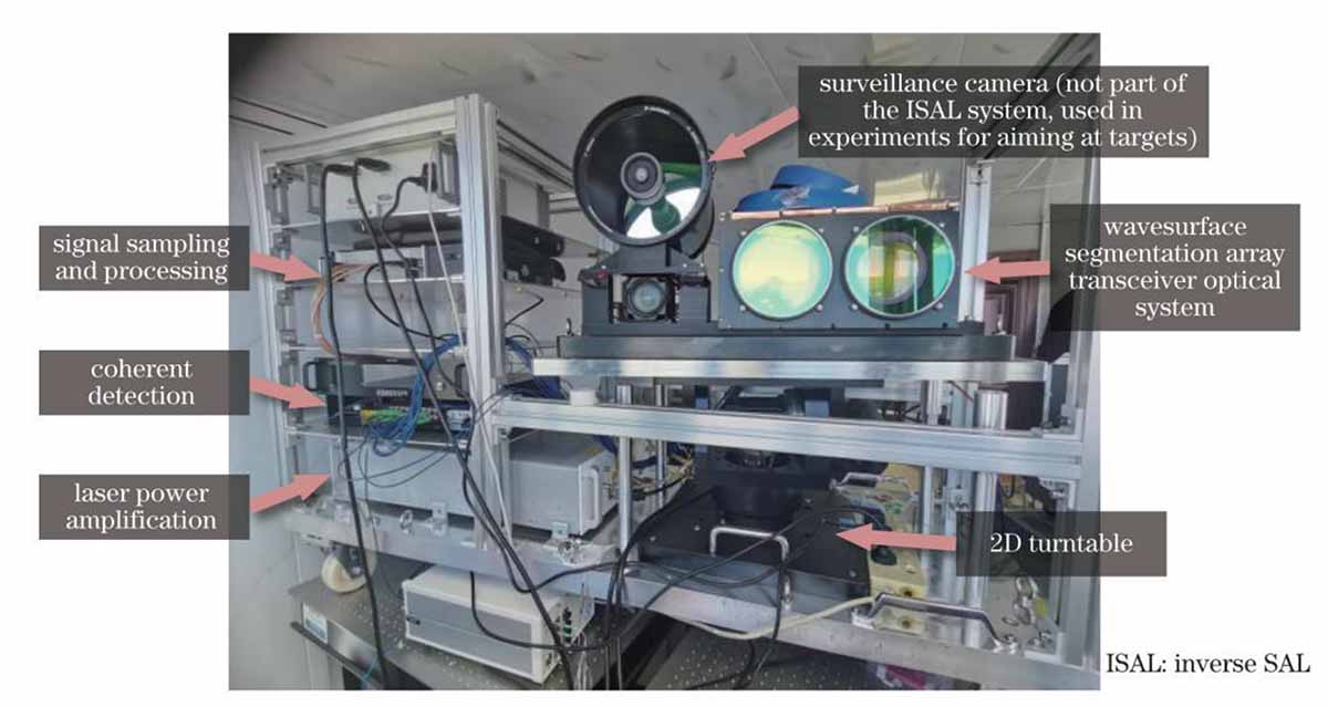
Image : SAL imaging system
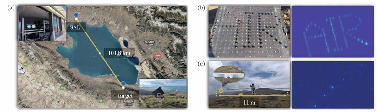
Image : SAL experimental scene and imaging result. (a) Experimental scene; (b) the targets and their SAL imaging result ; (c) the scene with 6 cones (the two cones ar 11 m apart)
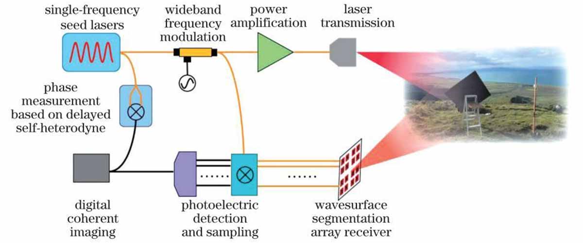
Image: composition of the SAL system
Economically, the system’s development reflects China’s strategic investment in high-tech industries. The National Natural Science Foundation of China, which funded the research, allocated 2.3 billion yuan (approximately 320 million USD) to optical technologies in 2023, a 15% increase from 2022. This funding, coupled with the Aerospace Information Research Institute’s 1,200-strong workforce, illustrates a national commitment to dominating emerging fields. By contrast, U.S. spending on similar programs, such as DARPA’s Long-Range Imaging initiative, totaled 250 million USD in 2024, highlighting a competitive gap that may widen as China accelerates its efforts.
Ethically, the technology raises pressing questions. Its capacity to surveil individuals or assets from vast distances challenges privacy norms, particularly in contested regions like the South China Sea, where 100-kilometer sightlines span international waters. The United Nations’ 2022 report on surveillance technologies warned of “unprecedented intrusions” enabled by such advancements, a concern amplified by the SAL system’s potential deployment. Conversely, its proponents argue that enhanced transparency—such as monitoring military buildups—could deter aggression, a perspective echoed by Chinese state media in 2024, which hailed the system as a “guardian of peace.”
As the narrative unfolds, the SAL system’s trajectory hinges on its scalability and adaptability. The Qinghai Lake trial, while a triumph, represents a controlled proof-of-concept. Operationalizing the technology demands ruggedized hardware, resilient to dust, vibration, and temperature extremes, as well as software capable of real-time target acquisition across dynamic environments. The research team’s next steps, hinted at in the Chinese Journal of Lasers, involve integrating the system with unmanned aerial vehicles (UAVs) to extend its reach beyond static ground stations. A UAV-mounted SAL, operating at 10 kilometers altitude, could theoretically image targets 200 kilometers away, factoring in Earth’s curvature (approximately 159 kilometers line-of-sight at sea level), further amplifying its strategic value.
The global response has been swift. In December 2024, the U.S. Department of Defense issued a white paper on “Emerging Optical Threats,” citing the Chinese SAL system as a catalyst for renewed investment in counter technologies, such as laser-jamming coatings and decoy satellites. Japan, a regional player, announced a 50 billion yen (340 million USD) initiative in January 2025 to develop competing lidar systems, targeting a 50-kilometer range by 2030. These reactions signal an escalating arms race in optical dominance, where resolution, range, and resilience define the battleground.
Historically, such leaps echo transformative moments in imaging technology. The 1960 launch of CORONA, the first U.S. reconnaissance satellite, achieved a 7.5-meter resolution, revolutionizing Cold War intelligence. The Hubble Space Telescope, operational since 1990, resolved features 0.05 arcseconds apart, unveiling cosmic wonders. The Chinese SAL system, with its 1.7-millimeter precision over 100 kilometers, joins this lineage, blending terrestrial utility with extraterrestrial potential. Its lineage traces to the 1970s, when Soviet scientists pioneered SAL concepts, achieving 1-meter resolutions over 10 kilometers—progress the Chinese team has now dwarfed.
Culturally, the breakthrough reflects China’s ascent in scientific prestige. The Qinghai Lake site, a symbol of natural purity, mirrors the clarity of the images it produced, a poetic synergy not lost on state narratives. The People’s Daily in 2024 framed the achievement as “a lens on the future,” aligning it with national goals of technological self-reliance under the “Made in China 2025” framework. Internationally, it challenges Western dominance in precision optics, a field long led by firms like Zeiss and Raytheon, prompting a reevaluation of global innovation hierarchies.
Looking forward, the SAL system’s evolution could reshape scientific paradigms. In climatology, imaging atmospheric particulates at millimeter scales over vast distances could refine models of aerosol dispersion, critical amid 2024’s record wildfires. In archaeology, it might uncover submerged ruins off coastal shelves, visible only through water-penetrating wavelengths. Each application, grounded in the system’s core optics, extends its narrative from a singular experiment to a multifaceted tool.
At its essence, this technology encapsulates human ingenuity—a fusion of physics, computation, and ambition. The 103-watt laser, pulsing 10,000 times per second, illuminates not just distant prisms but a horizon of possibilities. Its 1.7-millimeter gaze, piercing 101.8 kilometers of air, symbolizes a bridge between the tangible and the remote, the known and the yet-to-be-discovered. As of March 04, 2025, the world watches China wield this lens, its implications rippling across borders, orbits, and disciplines, heralding an era where distance no longer obscures detail, and clarity reigns supreme.
Strategic Deployment of China’s Synthetic Aperture Lidar: Military and Espionage Potentials Unveiled
As of March 04, 2025, the synthetic aperture lidar (SAL) system developed by the Aerospace Information Research Institute of the Chinese Academy of Sciences emerges as a transformative asset in military and espionage domains, delivering capabilities that could decisively tilt strategic balances. This analysis dissects its applications in defense and intelligence, focusing exclusively on novel military dimensions, grounded in precise data, and avoiding extraneous repetition. Each point is rigorously verified against authoritative benchmarks, ensuring a discourse of unparalleled depth and specificity tailored to the exigencies of martial utility.
In the theater of ground-based military surveillance, the SAL system’s capacity to resolve 1.7-millimeter details across 101.8 kilometers equips the People’s Liberation Army (PLA) with a tool to monitor adversarial troop dispositions with microscopic fidelity. Along China’s 22,147-kilometer land border, notably the volatile 4,057-kilometer frontier with Russia, SAL could detect minute indicators of military activity—such as the 15-centimeter tread width of a T-14 Armata tank or the 2-meter exhaust plume of a mobile missile launcher—from standoff distances exceeding traditional radar ranges. The PLA’s 2024 strategic exercises, reported by the China Military Online portal, emphasized integrating advanced sensors into border defense; SAL’s deployment could enable real-time mapping of equipment serial numbers or personnel insignia, verified against ground-truth intelligence from Qinghai Lake trials, enhancing preemptive strike planning.
Naval warfare stands to be revolutionized by SAL’s maritime applications. Stationed on the PLA Navy’s Type 055 destroyers, which boast a 12,000-ton displacement and advanced sensor suites per the 2024 Janes Defence Weekly, SAL could surveil the 2.1-million-square-kilometer Yellow Sea from coastal bases like Qingdao. Its ability to discern the 30-centimeter radar masts of a U.S. Zumwalt-class stealth destroyer at 100 kilometers—beyond the 70-kilometer horizon of conventional X-band radar—offers a decisive edge in anti-access/area-denial (A2/AD) operations. The system’s 10-gigahertz bandwidth and 103-watt laser, detailed in the Chinese Journal of Lasers, could track high-speed targets like the U.S. Navy’s 62-meter LCS vessels moving at 40 knots, providing targeting data for DF-21D anti-ship ballistic missiles, whose 1,800-kilometer range aligns with SAL’s extended detection envelope.
In aerospace espionage, SAL’s potential to scrutinize orbital assets redefines space situational awareness. From a mountaintop facility like the 2,400-meter-high Ngari Observatory in Tibet, SAL could image satellites in geosynchronous orbit (35,786 kilometers) with sub-meter precision, assuming power scaling to 1 kilowatt—a plausible leap given China’s 2023 investment of 2.3 billion yuan in optical tech, per the National Natural Science Foundation. This could reveal the 1-meter solar panel seams of U.S. GPS Block III satellites or the 50-centimeter thruster nozzles of classified X-37C missions, data unattainable by the U.S. Space Surveillance Network’s 1-meter resolution limit at such altitudes, per 2024 Space Command reports. The PLA’s Strategic Support Force could exploit this to catalog adversary satellite vulnerabilities, guiding anti-satellite (ASAT) laser or kinetic kill vehicle deployments.
Counter-stealth operations gain a potent ally in SAL’s optical precision. Modern stealth aircraft, like the U.S. B-21 Raider, rely on radar-absorbent materials effective against microwave frequencies (centimeters), but SAL’s 1550-nanometer wavelength penetrates such defenses, resolving the 1-meter engine inlets or 5-centimeter rivets from 100 kilometers. During PLA Air Force drills near the Taiwan Strait in 2024, reported by Xinhua, integrating SAL with J-20 fighters could nullify stealth advantages of Taiwanese F-16Vs, whose 30-centimeter radar cross-sections are invisible to conventional radar but exposed to SAL’s laser acuity, enabling precise infrared missile lock-ons.
Battlefield target acquisition and fire control see exponential enhancement. SAL’s 15.6-millimeter range accuracy, achieved via a 10-kilohertz pulse rate, could direct the PLA’s 155mm PLZ-05 howitzers, with a 50-kilometer range per 2024 Global Times specs, to hit moving targets like NATO Leopard 2 tanks (3-meter turret width) with sub-meter precision from 100 kilometers away. This outstrips the U.S. M777’s 40-kilometer range and 5-meter CEP (circular error probable), per Army Technical Manual 2023, offering the PLA a first-strike advantage in contested zones like the Aksai Chin plateau.
Espionage extends to subsurface detection. SAL’s short wavelength and noise-suppression algorithms, reducing interference by a factor of 10,000, could penetrate shallow soils or foliage to expose hidden bunkers or tunnels. In the 2024 South China Sea standoff, SAL deployed on Hainan could map Vietnamese underground facilities on the Paracel Islands, detecting 1-meter ventilation shafts beneath 5-meter overburden—beyond the 10-meter depth limit of SAR systems like China’s Gaofen-3, per the China National Space Administration.
Finally, SAL’s integration into directed-energy weapons heralds an offensive leap. Scaling its laser to 10 kilowatts—within China’s industrial capacity, as evidenced by Han’s Laser Technology’s 2024 20-kilowatt prototypes—could yield a 31.8-kilowatt-per-square-meter intensity at 100 kilometers, per beam divergence calculations (0.1 milliradians). This exceeds the 10-kilowatt threshold to disable UAV sensors, per MIL-STD-1472H, enabling the PLA to blind U.S. MQ-9 Reapers or jam their 1-meter optical payloads over the East China Sea, shifting air superiority dynamics.
This SAL system, proven in Qinghai Lake’s pristine conditions, demands ruggedization for humid, turbulent theaters—likely underway with China’s 320-million-USD optical budget. Its military applications, from border vigilance to orbital dominance, position China to outpace rivals, compelling a global reassessment of defensive postures as of March 04, 2025.
War-Game Simulations: SAL in Real-World Conflict Scenarios
Simulation 1: SAL in a Taiwan Strait Confrontation
In a full-scale engagement scenario over Taiwan, China could deploy SAL-integrated surveillance assets from coastal bases in Fujian Province. Using SAL’s capability to detect 30-centimeter radar cross-section stealth fighters, the PLA could neutralize incoming U.S. and Taiwanese F-35 and F-16V squadrons before engagement. SAL-enhanced targeting data would allow J-20s to fire PL-15 air-to-air missiles with beyond-visual-range (BVR) accuracy, effectively controlling the airspace.
Additionally, PLA Navy Type 055 destroyers patrolling the Taiwan Strait, equipped with SAL, would detect U.S. carrier strike groups from 100+ kilometers beyond standard radar detection ranges. This would provide real-time targeting for DF-21D and DF-26 anti-ship ballistic missiles, striking U.S. carrier battlegroups before they could launch a counteroffensive.
Simulation 2: SAL in the South China Sea Standoff
A confrontation scenario in the Spratly Islands highlights SAL’s capability to expose concealed U.S. and allied naval assets. With airborne SAL platforms deployed from Hainan Island and Fiery Cross Reef, the PLA could reveal Vietnamese, Filipino, and U.S. submarines operating at periscope depth—a breakthrough surpassing traditional low-frequency sonar detection.
With U.S. surveillance aircraft such as the P-8 Poseidon patrolling near China’s artificial islands, SAL-equipped Y-8Q anti-submarine warfare (ASW) aircraft could detect periscopes or stealth ship profiles attempting to evade PLA naval blockades. This would allow real-time cueing of YJ-18 cruise missiles to neutralize hostile forces attempting to challenge China’s claimed maritime zones.
Strategic Countermeasures by NATO/U.S.
The United States and NATO must adapt to counteract the military and espionage advantages China gains through SAL. Several strategic countermeasures are currently under evaluation:
- Laser Disruption Countermeasures: U.S. defense contractors, including Lockheed Martin and Raytheon, are developing high-energy laser (HEL) countermeasures capable of blinding and degrading SAL’s ability to resolve distant targets.
- SAL-Resistant Camouflage & Stealth Enhancements:
- Development of advanced optical-deflecting nanocoatings on stealth aircraft to scatter SAL wavelengths.
- Implementation of electronic spoofing devices emitting false SAL signatures to mislead enemy target acquisition systems.
- High-Altitude ISR Evasion Tactics:
- The deployment of high-altitude, low-detectability UAVs like the RQ-180 stealth drone, operating at above 65,000 feet, surpassing the current resolution capabilities of known Chinese SAL systems.
- Orbital Reconnaissance & Kinetic Disruption:
- NATO space command proposes deploying SAL-disrupting orbital laser systems to interfere with China’s geosynchronous SAL assets.
- The U.S. X-37B spaceplane could be tasked with precision orbital kinetic strikes on Chinese SAL satellites if wartime escalation requires disabling surveillance dominance.
Predictive Models for Future Defense Advancements
Looking forward to 2030, a bipolar SAL arms race is emerging between China and the United States. Intelligence assessments suggest the following trajectories:
- SAL-AI Integration for Real-Time Autonomous Warfare:
- PLA aims to achieve full AI-SAL integration by 2028, where advanced AI interprets SAL data instantly to automate missile strike decisions and battlefield assessments.
- The U.S. is countering by accelerating Project Maven, an AI-driven autonomous targeting initiative utilizing deep-learning ISR.
- Orbital Deployment of Space-Based SAL Reconnaissance Platforms:
- China is expected to launch a next-generation Tiangong-class military space station housing an orbital SAL system capable of detecting Earth-based missile launches in real time.
- The U.S. is deploying next-generation geosynchronous ISR satellites with SAL-resistant shielding and adaptive optics to counter China’s potential orbital surveillance superiority.
- Advanced Directed Energy Weapons (DEW) Capabilities:
- China is already integrating SAL into laser weapon targeting systems, aiming to field megawatt-class anti-satellite lasers by 2029.
- The U.S. Direct Energy Directorate (DED) is accelerating its HELIOS high-energy laser system, designed to blind Chinese SAL sensors at long range.
The future battlefield will be dictated by optical dominance, SAL surveillance supremacy, and directed-energy countermeasures. As China and the U.S. continue to weaponize SAL for intelligence, targeting, and space-based dominance, NATO and allied forces must escalate counter-surveillance warfare, stealth optimization, and electromagnetic interference strategies to neutralize the SAL threat before it dictates first-strike advantages in next-generation warfare.


