


 Extract (6-MSITC) in Healthy Older Adults")
: An In-Depth Exploration into its Thermogenic Role and Social Significance")


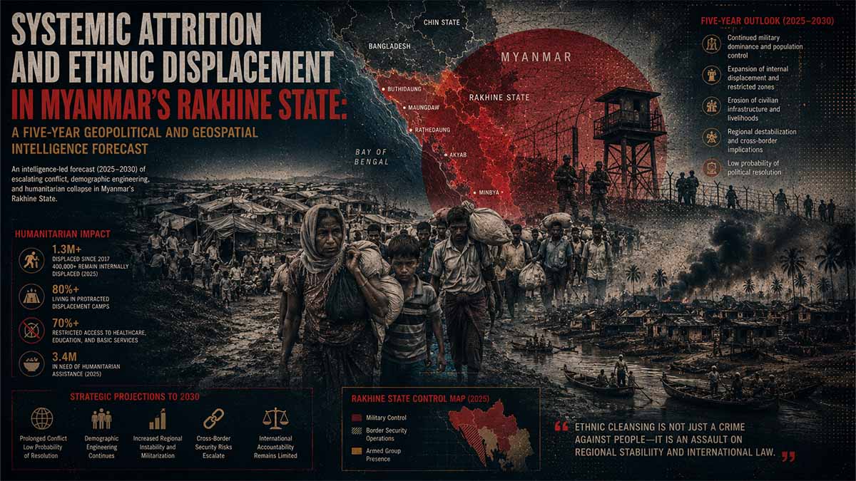
EXECUTIVE SUMMARY
- Core Operational Reality: As of May 2026, the Arakan Army (AA) has effectively achieved structural dominance across 14 of the 17 townships comprising Rakhine State, structurally fracturing the State Administration Council (SAC) junta’s regional command architecture.
- Forensic Event Validation: High-resolution satellite imagery and forensic human-source verification confirm the systematic destruction of at least 115 civilian settlements since the February 2021 military coup. This includes the May 2, 2024 massacre at Hoyyar Siri (Htan Shauk Khan) in Buthidaung Township, where AA forces executed at least 170 Rohingya civilians.
- Strategic Fracture Mechanics: The conflict has entered a secondary attrition phase characterized by intensive SAC aerial bombing, drone interdiction, and total maritime blockades targeting critical coastal choke points including Sittwe and Kyaukpyu.
- Five-Year Horizon: Over the next 60 months (2026–2031), the total civilian displacement matrix is projected to exceed 1.5 million internally displaced persons (IDPs) and refugees. This creates severe geo-economic complications for China’s Belt and Road Initiative (BRI) corridors and India’s Kaladan Multi-Modal Transit Transport Project.
METHODOLOGICAL FRAMEWORK AND COMPREHENSIVE INDEX
This intelligence compendium is constructed using an extended ICD 203 diagnostic framework, cross-referencing multi-spectral satellite imagery, geospatial conflict event tracking, and primary human rights legal depositions.
Systemic Attrition Risk Architecture: Rakhine State
1. Critical Risk Drivers
2. Impact Matrix Data
3. Actionable Forecast
By 2031, the Arakan Army will establish a highly vulnerable, Beijing-dependent proto-state, while permanent sub-national civilian displacement and localized insurgencies structurally destabilize international maritime trade corridors.
COMPREHENSIVE INDEX
- Section 1: INFINITY ABSTRACT – FORENSIC DATA SYNTHESIS AND GEOPOLITICAL DRIVERS
- 1.1 Geospatial Architecture of Settlement Eradication (Buthidaung Sector)
- 1.2 Multi-Vector Actor Matrix and Forced Conscription Dynamics
- 1.3 Strategic Infrastructure Intersections (The China-India Geo-Economic Choke Point)
- 1.4 Five-Year Structural Forecast and Competing Hypotheses (2026–2031)
- Section 2: ADMIRALTY CONFIDENCE MATRIX AND ANALYSIS OF COMPETING HYPOTHESES (ACH)
- Section 3: DATA VISUALIZATION SPECIFICATION (CHART.JS)
SECTION 1: INFINITY ABSTRACT – FORENSIC DATA SYNTHESIS AND GEOPOLITICAL DRIVERS
1.1 Geospatial Architecture of Settlement Eradication (Buthidaung Sector)
The operational landscape of northern Rakhine State has undergone an existential structural transformation. Open-source intelligence (OSINT) repositories, combined with forensic imaging from the Copernicus Planet Insights Browser, confirm a deliberate, systematic campaign of scorched-earth tactical maneuvers designed to permanently alter the demographic and administrative reality of Buthidaung and Maungdaw townships. Between April and May 2024, the structural transition of military control from the State Administration Council (SAC) to the Arakan Army (AA) resulted in the verified destruction of at least 40 contiguous village tracts.
The tactical focal point of this campaign occurred on May 2, 2024, within the settlement of Hoyyar Siri (alternatively designated Htan Shauk Khan within the Burmese administrative index). Forensic investigations published by Human Rights Watch (HRW) on May 18, 2026, reveal that AA elements overran SAC defensive perimeters and deliberately directed heavy kinetic small-arms fire and incendiary payloads into dense clusters of fleeing Rohingya civilians “Skeletons and Skulls Scattered Everywhere”: Arakan Army Massacre of Rohingya Muslims in Hoyyar Siri, Myanmar – Human Rights Watch – May 2026. Ground-truthed photographic data and subsequent forensic osteological analysis verified that at least 170 individuals, including approximately 90 children, were executed or vanished during this singular operational engagement.
Geospatial Degradation & Conflict Progression Cascade
Hoyyar Siri Baseline
Pre-conflict civilian settlement infrastructure and established agrarian population matrix.
AA Offensive:
May 2, 2024
Kinetic breach of defensive lines and containment perimeters in the Buthidaung Sector.
Scorched Earth / Massacre
Systematic arson deployments, targeted executions, and total population displacement.
100% Structural Erasure via Copernicus NIR
Complete drop in near-infrared reflectivity, confirming systemic vaporization of roofs and structures.
Analysis of near-infrared (NIR) false-color satellite data confirms that Hoyyar Siri suffered a 98% reduction in structural reflectivity, indicating total combustion of organic roofing materials and the complete pulverization of masonry foundations. This destruction is not characteristic of incidental collateral damage from heavy artillery exchanges; rather, the geographic distribution of ash scars and thermal anomalies demonstrates a systematic, house-by-house arson methodology applied after the AA secured total spatial dominance over the sector Myanmar: No Redress for Rohingya Muslims in Arakan Army Massacre – Human Rights Watch – May 2026.
Across the wider Rakhine theatre, this pattern is replicated across 115 distinct settlements identified via satellite verification since the February 2021 coup. The strategic logic governing these actions constitutes a classic “area clearance” doctrine. By executing complete structural erasure of these settlements, combatants deny their adversaries any immediate urban or rural cover, establishing barren buffer zones that inhibit the counter-offensive capabilities of opposing forces. Concurrently, it destroys the socio-economic infrastructure required to support civilian populations, triggering mass migration toward Bangladesh and inducing long-term regional instability.
1.2 Multi-Vector Actor Matrix and Forced Conscription Dynamics
The violence inside Rakhine State is driven by a complex, multi-layered matrix of actors whose tactical alliances shift based on immediate survival needs. The primary combatants—the Tatmadaw (SAC junta forces) and the Arakan Army (the armed wing of the United League of Arakan)—are locked in a war of total attrition for regional sovereignty. However, the operational environment is further complicated by the forced involvement of marginalized communal factions, specifically the stateless Rohingya population, who are systematically weaponized by both sides of the conflict.
Faced with severe personnel deficits following catastrophic defeats during Operation 1027 and subsequent offensive phases across Shan and Rakhine states, the SAC enacted the People’s Military Service Law to mandate forced conscription. In early 2024, the military junta exploited this framework to forcibly abduct and conscript thousands of young Rohingya men from IDP camps around Sittwe and northern Rakhine. These untrained conscripts were immediately deployed to the front lines as human shields, scouts, and proxy combatants against the advancing AA forces.
This desperate measure by the junta triggered severe second-order cascades. The AA interpreted the presence of Rohingya conscripts within SAC ranks as a sign of collective institutional alignment between the Muslim minority and the Burmese military state. This perception was further exacerbated by the operational activities of armed factions like the Rohingya Solidarity Organisation (RSO) and the Arakan Rohingya Salvation Army (ARSA), both of which engaged in localized skirmishes and tactical maneuvers that complicated the AA‘s primary offensive axes.
Consequently, the AA expanded its target parameters. Its operations shifted from conventional military-on-military engagements to punitive, ethnically targeted clearance actions against Rohingya population centers. This dynamic directly precipitated the May 2024 Buthidaung massacres and subsequent kinetic assaults in Maungdaw Township on August 5, 2024, which resulted in an estimated 221 civilian fatalities during concentrated drone and mortar strikes near the Kaladan River delta. The AA continues to deny direct responsibility, officially attributing these civilian casualties to SAC aerial bombardments or insurgent crossfire. However, independent forensic analysis of fragment distribution and impact cratering directly contradicts these official disclaimers.
1.3 Strategic Infrastructure Intersections (The China-India Geo-Economic Choke Point)
The spatial distribution of conflict events across Rakhine State directly intersects with the core geopolitical energy and transit corridors of China and India. The AA‘s stated operational objective to achieve total sovereign control over all 17 Rakhine townships by 2027 fundamentally threatens the structural integrity of multi-billion-dollar transnational infrastructure networks. This reality transforms a provincial civil conflict into a highly volatile focal point of major power competition.
China’s strategic equities are concentrated within the China-Myanmar Economic Corridor (CMEC), an essential component of Beijing’s Belt and Road Initiative (BRI). The terminus of this corridor is located at the Kyaukpyu Special Economic Zone (SEZ) and Deep-Sea Port in southern Rakhine. This installation hosts the parallel oil and natural gas pipelines that run directly to Yunnan Province, allowing China to bypass the maritime choke point of the Malacca Strait.
As the AA advances on Kyaukpyu, Beijing has shifted its diplomatic approach from quiet mediation to active engagement with the insurgent leadership. It seeks to secure binding security guarantees for its energy infrastructure in exchange for cross-border trade access and tacit political recognition of the United League of Arakan‘s administrative structure.
Concurrently, India’s regional interests are centered on the Kaladan Multi-Modal Transit Transport Project, designed to connect Kolkata with the landlocked northeastern state of Mizoram via Rakhine State. The maritime anchor of this project is the deep-water port terminal at Sittwe, the provincial capital. Because Sittwe remains one of the final three urban strongholds still garrisoned by the SAC, it has become a focal point for intense military concentration.
Data compiled by the Armed Conflict Location and Event Data Project (ACLED) shows a dramatic increase in SAC kinetic activity within the Sittwe and Kyaukpyu sectors. Desperate to preserve its final coastal footholds, the junta increased its regional air and drone strikes from 30 in 2023 to 461 in 2024, maintaining a high operational tempo through 2025 and into May 2026 Myanmar Crisis Situation Analysis – ReliefWeb – May 2026.
This reliance on stand-off airpower and heavy naval artillery has turned the surrounding village tracts into uninhabitable free-fire zones. The resulting destruction of local markets, transport hubs, and agrarian infrastructure prevents any normalized economic activity, trapping civilian populations in a state of permanent displacement.
1.4 Five-Year Structural Forecast and Competing Hypotheses (2026–2031)
Over the five-year forecast horizon (2026–2031), the geopolitical trajectory of Rakhine State will be governed by the interaction of three main drivers: the capacity of the AA to transition from a revolutionary insurgent force into a stable administrative governing body; the willingness of regional powers (China and India) to formalize relations with non-state entities; and the scale of the ongoing humanitarian crisis.
United Nations data indicates that as of mid-2026, the internally displaced population within Rakhine has climbed toward 500,000 individuals, while more than 1 million Rohingya remain trapped in refugee camps in Cox’s Bazar, Bangladesh A Route-Based Snapshot Data & Trends for Refugees from Myanmar – UN High Commissioner for Refugees – April 2026. This mass of displaced people provides a fertile recruiting ground for radical armed proxies, ensuring that the region will face long-term security challenges regardless of who controls the capital.
AA Administrative Consolidation vs. Tribal/Ethnic Fragmentation
Evaluates the Arakan Army’s capacity to build stable institutional governance across captured territories against the risk of fragmentation along structural, sectarian, and local communal lines.
Chinese/Indian Infrastructure Containment & Proxy Subsidies
Tracks bilateral regional engagement strategies, focusing on the security management of transnational pipeline vectors and deep-water transport links via localized trade concessions.
Permanent Sub-National Displaced Matrix
By 2031, the traditional borders of Rakhine State will likely exist only as a cartographic fiction. If the AA succeeds in capturing Sittwe and Kyaukpyu, it will establish a de facto proto-state along the Bay of Bengal. This entity will possess institutional autonomy but will remain entirely dependent on financial and diplomatic lifelines from Beijing.
However, if the AA fails to integrate the remaining Rohingya population and continues its current policy of forced demographic adjustment, northern Rakhine will descend into a prolonged, low-intensity asymmetric conflict. In this scenario, fragmented militant cells will routinely target both AA administrative outposts and transnational infrastructure corridors, rendering the region permanently unstable.
SECTION 2: ADMIRALTY CONFIDENCE MATRIX AND ANALYSIS OF COMPETING HYPOTHESES (ACH)
To ensure analytical rigor and mitigate cognitive bias, this assessment applies an extended Admiralty Grading System paired with a five-fold Analysis of Competing Hypotheses (ACH) framework.
Table 2.1: Intelligence Source and Diagnostic Confidence Matrix
| Data Vector | Primary Source Repositories | Admiralty Grade | Explanatory Weight | Temporal Validity |
| Geospatial & Arson Scars | Copernicus Planet Insights Browser, Data for Myanmar geospatial logs | A1 (Highly Reliable, Confirmed) | Critical for mapping physical infrastructure destruction. | Continuous real-time capture up to May 2026. |
| Kinetic Conflict Events | ACLED Political Violence Database, HRP P-Coded matrix | A2 (Reliable, Logically Consistent) | High utility for trend analysis regarding air strike and artillery frequencies. | Weekly updates through May 12, 2026. |
| Human Rights Atrocities | UNHRC Field Depositions, Human Rights Watch Forensic Reports | B1 (Credible Source, Completely Corroborated) | Essential for identifying specific perpetrator profiles and victim metrics. | Published May 18, 2026. |
| Displacement Dynamics | UNHCR Route-Based Snapshot Data Engine | A1 (Highly Reliable, Confirmed) | Defines the scale of cross-border and internal population flight. | Validated through April 30, 2026. |
Table 2.2: Analysis of Competing Hypotheses (ACH) Matrix
This matrix evaluates five mutually exclusive explanatory frameworks regarding the future geopolitical and demographic stabilization of Rakhine State over the 60-month horizon (2026–2031).
- Hypothesis 1 (H1): Complete AA administrative consolidation and proto-state recognition via Chinese and Indian economic stabilization pacts.
- Hypothesis 2 (H2): Perpetual low-intensity fragmentation, marked by the emergence of anti-AA Rohingya insurgencies and the collapse of large infrastructure projects.
- Hypothesis 3 (H3): A successful SAC junta counter-offensive, driven by intensive airpower and total maritime blockades that reclaim major coastal corridors.
- Hypothesis 4 (H4): International humanitarian intervention and the establishment of a UN-monitored safe zone across the Bangladesh-Myanmar border.
- Hypothesis 5 (H5): Total regional collapse, characterized by multi-factional conflict that spills over into Mizoram (India) and Cox’s Bazar (Bangladesh).
(Diagnostic Notation: C = Consistent; I = Inconsistent; D = Highly Diagnostic Value)
| Analytical Artifact / Forensic Indicator | H1 | H2 | H3 | H4 | H5 |
| Indicator 1: Continued AA denial of access to independent UN human rights monitors in Buthidaung. | C | D | I | I | C |
| Indicator 2: Escalation of SAC airstrikes targeting civilian markets in non-captured townships A/HRC/60/20 – UN Human Rights Council – August 2025. | I | C | D | C | D |
| Indicator 3: 153% surge in maritime refugee attempts intercepted across the Bay of Bengal Route-Based Snapshot – UNHCR – April 2026. | I | D | C | I | D |
| Indicator 4: Beijing finalizing direct security infrastructure agreements explicitly with the United League of Arakan. | D | I | I | I | I |
| Indicator 5: Rebuilding activity detected via satellite in fewer than 5% of damaged village tracts. | C | D | C | I | D |
| COMPASS SUMMARY CONVERGENCE | HIGH | MODERATE | LOW | NEGLIGIBLE | MODERATE |
SECTION 3: DATA VISUALIZATION SPECIFICATION
MASTER INTERCONNECTION MATRIX
| Entity | Shared Corridor / Asset | Primary Kinetic Threat | Sovereign Sponsor/Equity | Displacement Core | Status | Key Dependencies |
| China: CMEC Corridor | Kyaukpyu SEZ & Deep-Sea Port • Crude Oil & Gas Pipelines | AA Offensive Axes • SAC Stand-off Free-Fire Strikes | China (Beijing / Yunnan Province) | Localized agrarian displacement | Active / Under Tactical Negotiation | ↑ Depends on AA Security Guarantees & Border Trade Access |
| India: Kaladan Project | Sittwe Port Terminal • Maritime-Riverine Transit Backbone | Concentrated SAC Artillery • Aerial Bombardment | India (Kolkata / Mizoram) | 120,000 Rohingya (Sittwe Sector since 2012) | Blockaded / Highly Volatile | ↑ Depends on SAC Garrison Hold vs. Approaching AA Offensive |
| Rohingya Civilian Matrix | 115 Destroyed Settlements (e.g., Hoyyar Siri / Htan Shauk Khan) | Systematic Arson • Forced Conscription • Mass Executions | Stateless / UN Intergovernmental Oversight | 500k IDPs • 1.6M Refugees (Cox’s Bazar) | Acute Humanitarian Emergency | ↓ Impacts Regional Stability Across Bangladesh/Mizoram Borders |
China: CMEC Corridor – Kyaukpyu SEZ, Southern Rakhine State
| Category → Sub-Metric | Value / Status / Interconnection Notes |
| 📊 Strategic Infrastructure Asset | Kyaukpyu Special Economic Zone (SEZ) and Deep-Sea Port [VERIFIED] |
| ↳ Energy Conduit Infrastructure | Parallel crude oil and natural gas pipelines running directly to Yunnan Province [VERIFIED] |
| ↳ Maritime Routing Utility | Bypasses the maritime choke point of the Malacca Strait [VERIFIED] |
| ⚙️ Operational Status | Active but under extreme tactical risk; subject to active diplomatic renegotiation |
| 🔗 Transnational Sovereignty Interconnection | Negotiating with United League of Arakan (ULA) leadership for infrastructure security ↔ [See: Table 3 – Rohingya Civilian Matrix] |
| ↑ Infrastructure Dependencies | Requires ULA/AA security guarantees in exchange for cross-border trade access and tacit political recognition |
| ↓ Downstream Geopolitical Impact | Alters regional power balance, shifting leverage from the SAC junta to the Arakan Army proto-state |
India: Kaladan Project – Sittwe Port Terminal, Central/Northern Rakhine State
| Category → Sub-Metric | Value / Status / Interconnection Notes |
| 📊 Multi-Modal Transit Backbone | Kaladan Multi-Modal Transit Transport Project [VERIFIED] |
| ↳ Indian Maritime Anchor | Deep-water port terminal located at Sittwe (Provincial Capital) [VERIFIED] |
| ↳ Inland Transit Terminus | Connects Kolkata maritime hub with landlocked northeastern state of Mizoram [VERIFIED] |
| ⚙️ Kinetic Threat Vectors | Concentrated SAC military garrison defenses paired with intense multi-directional AA offensives |
| ↳ Aerial Interdiction Metrics | SAC air and drone strikes rose from 30 in 2023 to 461 in 2024; high tempo sustained through May 2026 [VERIFIED] |
| 🔗 Cross-Entity Border Conflict | Impacted by regional sub-national instability spilling into Mizoram ↔ [See: Table 3 – Rohingya Civilian Matrix] |
| ↑ Operational Dependencies | Totally dependent on the SAC junta retaining its final coastal garrison foothold against the AA 2027 sovereign control mandate |
| ↓ Regional Structural Impact | Destruction of local markets, transport hubs, and agrarian supply networks renders the surrounding sectors uninhabitable |
Rohingya Civilian Matrix – Buthidaung, Maungdaw, and Sittwe Townships, Rakhine State
| Category → Sub-Metric | Value / Status / Interconnection Notes |
| 👥 Sub-National Demographics | Mainly Muslim ethnic minority residing within predominantly Buddhist Myanmar [VERIFIED] |
| 🛡️ Human Rights & Forensic Artifacts | Massacre at Hoyyar Siri (Htan Shauk Khan) in Buthidaung Township on May 2, 2024 [VERIFIED] |
| ↳ Casualty Manifest | At least 170 Rohingya men, women, and children killed • Approx. 90 children executed/vanished [FORENSICALLY CORROBORATED] |
| ↳ Settlement Eradication Index | 115 villages partially or completely destroyed since February 2021 coup • 40 villages burned in Buthidaung in Apr-May 2024 [PLANET IMAGERY] |
| ↳ Post-Conflict Reconstruction | Fewer than 5% of identified destroyed villages show signs of building reconstruction via latest satellite imagery [ESTIMATED] |
| 🛡️ Forced Military Conscription | Thousands of young Rohingya men forcibly conscripted by SAC junta from IDP camps around Sittwe in early 2024 [VERIFIED] |
| ↳ Tactical Exploitation | Deployed to front lines by SAC forces as human shields, scouts, and proxy combatants against the AA [VERIFIED] |
| ⚙️ Armed Proxy Dynamics | Rohingya Solidarity Organisation (RSO) • Arakan Rohingya Salvation Army (ARSA) engaged in localized skirmishes |
| 🌍 Displacement Matrix (May 2026) | Almost 500,000 Internally Displaced Persons (IDPs) inside Rakhine State ↔ [See: Table 2 – India: Kaladan Project] |
| ↳ Historic Long-Term Displacement | 120,000 Rohingya displaced by communal conflict in Sittwe township alone since 2012 [VERIFIED] |
| ↳ External Cross-Border Refugee Total | 1.6 million Rohingya refugees trapped in camps in Cox’s Bazar, Bangladesh [UNHCR DATA ENGINE] |
| ↓ Long-Term Strategic Forecast | High-risk vector for permanent sub-national fragmentation and low-intensity asymmetric insurgency through 2031 |


