")


 Extract (6-MSITC) in Healthy Older Adults")
: An In-Depth Exploration into its Thermogenic Role and Social Significance")


Abstract
The Strait of Malacca represents one of the most structurally critical nodes in the contemporary global maritime system, functioning as a high-density geoeconomic artery linking the Indian Ocean energy basin with the industrial demand centers of East Asia. Its strategic importance is not merely a function of volume throughput, but rather of its position within a highly optimized, low-redundancy global logistics network characterized by just-in-time supply chains, energy interdependence, and financialized trade flows. In the evolving geopolitical context—particularly amid rising tensions involving Iran, China, and U.S.-aligned maritime security architectures—the Strait of Malacca emerges as a plausible secondary escalation theater following disruptions in the Strait of Hormuz, forming part of a multi-chokepoint systemic vulnerability structure.
Empirical data consistently identify Malacca as one of the busiest maritime corridors globally. According to the U.S. Energy Information Administration (EIA), approximately 23–25 million barrels of oil per day transit the strait, representing a substantial portion of global seaborne petroleum flows (https://www.eia.gov/international/analysis/special-topics/World_Oil_Transit_Chokepoints.php). Parallel assessments by UNCTAD confirm that roughly one-third of global maritime trade volume passes through this corridor, reinforcing its role as a critical bottleneck in global commerce (https://unctad.org/topic/transport-and-trade-logistics/review-of-maritime-transport). At its narrowest point—near the Phillips Channel—it constricts to approximately 2.7–2.8 km, creating a physical vulnerability amplification factor whereby even limited disruptions can yield disproportionate systemic effects.
From an energy security perspective, the Strait of Malacca constitutes the primary import route for China, Japan, South Korea, and Taiwan, all of which rely heavily on hydrocarbons sourced from the Middle East. The International Energy Agency (IEA) has repeatedly emphasized that China’s oil import dependency exceeds 70%, with a significant proportion transiting Malacca (https://www.iea.org/reports/china-energy-outlook). This dependency structure has given rise to what Chinese strategic discourse refers to as the “Malacca Dilemma”—a recognition that external actors could theoretically constrain China’s energy lifelines through maritime interdiction.
The strategic logic underpinning Malacca’s potential emergence as a crisis node is deeply embedded in network theory and systems fragility analysis. Unlike isolated chokepoints, Malacca operates within a multi-node dependency network that includes Hormuz, Bab el-Mandeb, and the Suez Canal. Disruption at one node induces load redistribution effects across the network, often exceeding alternative route capacities. For example, rerouting vessels around the Lombok or Sunda Straits significantly increases transit times and fuel costs, thereby introducing second-order economic shocks in freight pricing, insurance premiums, and commodity markets. These dynamics align with complex adaptive systems theory, wherein tightly coupled systems exhibit non-linear cascade behaviors under stress.
The geopolitical dimension is equally critical. Statements attributed to Iranian strategic circles referencing potential “chain-reaction responses” across maritime chokepoints reflect an implicit understanding of asymmetric escalation strategy. Rather than directly confronting superior naval forces in a single theater, a distributed disruption model targeting multiple chokepoints could impose system-wide economic costs on adversaries. This aligns with doctrines of non-linear warfare and strategic deterrence through economic disruption, where the objective is not territorial control but systemic destabilization of global flows.
At the same time, the Strait of Malacca is not a passive vulnerability but an actively managed security environment involving littoral states (Malaysia, Singapore, Indonesia) and external naval actors, including the United States Navy and increasingly the People’s Liberation Army Navy (PLAN). Cooperative mechanisms such as the Malacca Strait Patrols (MSP) and regional maritime domain awareness initiatives have historically reduced piracy and localized threats. However, these frameworks are not designed to withstand state-level hybrid disruptions, including cyber interference with port logistics, GPS spoofing, or coordinated blockade scenarios.
From a financial systems perspective, Malacca’s significance extends into the domain of global capital markets and insurance structures. Maritime trade disruptions translate rapidly into oil price volatility, which in turn affects derivatives markets, sovereign risk spreads, and inflation trajectories. Institutions such as the International Monetary Fund (IMF) and World Bank have documented the sensitivity of global GDP growth to energy price shocks, particularly those arising from supply chain disruptions (https://www.imf.org/en/Publications/WEO). Thus, Malacca’s vulnerability is not confined to physical trade but propagates through financial contagion channels, reinforcing its role as a systemic risk amplifier.
Five mutually exclusive explanatory frameworks help contextualize why Malacca could become the next major chokepoint:
- Energy Security Driver – escalation in the Middle East forces adversaries to target downstream transit routes.
- Great Power Competition Driver – U.S.–China rivalry extends into maritime control of Indo-Pacific sea lanes.
- Network Fragility Driver – cumulative stress across chokepoints triggers cascading failure dynamics.
- Hybrid Warfare Driver – non-kinetic disruptions (cyber, legal, economic) target maritime infrastructure.
- Economic Coercion Driver – chokepoint leverage used as a tool of strategic economic pressure.
Each framework yields different probability distributions and policy implications, requiring Bayesian updating as new intelligence emerges.
In conclusion, the Strait of Malacca is not merely a geographic bottleneck but a central node in a deeply interconnected global system. Its potential disruption would generate multi-domain cascading effects across energy markets, trade logistics, financial systems, and geopolitical stability. As global tensions intensify and the architecture of international trade becomes increasingly strained, Malacca stands as a critical fault line—one whose destabilization could redefine the contours of global order in the 21st century.
Index / Navigational Framework
Chapter I – Structural Foundations of Maritime Chokepoints
- Definition and typology of chokepoints (geographic vs systemic)
- Historical evolution: from colonial sea lanes to globalized logistics networks
- Comparative analysis: Hormuz, Malacca, Bab el-Mandeb, Suez
- Theoretical grounding in network theory and complex systems
Chapter II – The Strait of Malacca in the Global System
- Geographic and physical constraints (bathymetry, width, navigational density)
- Trade volume analysis (oil, LNG, container flows)
- Energy dependency mapping (China, Japan, South Korea, ASEAN)
- Infrastructure and surveillance architecture (ports, naval patrols, chokepoint governance)
Chapter III – Escalation Pathways and Systemic Risk
- Scenario modeling: disruption, blockade, hybrid interference
- Economic cascade effects (oil prices, shipping costs, inflation)
- Military-strategic implications (naval deployments, deterrence models)
- Alternative routes and their limitations (Lombok, Sunda, Arctic pathways)
Chapter I: Structural Foundations of Maritime Chokepoints
A maritime chokepoint is not only a narrow water passage. In legal and operational terms, it is a strait, canal, or constrained maritime corridor whose interruption materially alters the movement of internationally traded cargo, naval traffic, or both. The legal baseline for the category “straits used for international navigation” is set out in Part III of the United Nations Convention on the Law of the Sea, especially Articles 37–44, which establish the regime of transit passage through straits used for international navigation United Nations Convention on the Law of the Sea – United Nations – 1982. That matters analytically because a chokepoint is not merely a geographic bottleneck; it is a legally structured artery embedded in a global circulation system whose interruption has consequences for commercial access, passage rights, and strategic signaling United Nations Convention on the Law of the Sea – United Nations – 1982.
The most useful distinction for this chapter is between geographic chokepoints and systemic chokepoints. A geographic chokepoint is a physically narrow or operationally constrained passage whose morphology concentrates traffic. Official U.S. Energy Information Administration material repeatedly defines chokepoints as narrow channels along widely used global sea routes that are critical to global energy security World Oil Transit Chokepoints – U.S. Energy Information Administration – updated 2025/2026 site edition. A systemic chokepoint is broader: it exists when interruption at one route forces network-wide rerouting, raises ton-mile demand, shifts freight rates, disturbs inventory timing, and propagates costs across ports, shipping markets, and commodity chains. UNCTAD documented exactly this dynamic during the Red Sea/Suez disruption, noting that rerouting around the Cape of Good Hope lengthened distances and transit times, raised operational costs, and increased effective vessel demand Review of Maritime Transport 2024 – UN Trade and Development – July 2024.
That distinction clarifies why not every narrow passage becomes globally decisive. A waterway becomes a first-order chokepoint only when three conditions converge: physical constraint, high traffic concentration, and limited substitutability. The physical constraint is obvious in narrow channels and single-lane or heavily managed passages. Traffic concentration is visible in corridors through which major shares of energy or merchandise trade pass. Limited substitutability appears when alternative routes are materially longer, more expensive, shallower, politically riskier, or capacity-constrained. UNCTAD’s 2024 and 2026 publications show that rerouting away from the Suez Canal increased voyage distances, pushed up charter and fuel costs, and altered freight markets far beyond the immediate theater of disruption Review of Maritime Transport 2024 – UN Trade and Development – July 2024 Global maritime transport: Staying the course in turbulent waters – UN Trade and Development – 2026.
Historically, the modern chokepoint system was not born with contemporary globalization. It emerged through the interaction of imperial sea control, canal engineering, hydrocarbon trade, and containerization. The clearest official historical example is the Suez Canal. The Suez Canal Authority records that the modern canal’s digging began on 25 April 1859 and that inauguration occurred on 17 November 1869 Canal History – Suez Canal Authority – live page. The same authority records that the canal was nationalized by the Egyptian Government on 26 July 1956, closed after the 1967 war, and reopened for international navigation in June 1975 Canal Characteristics – Suez Canal Authority – live page. Those dates are not merely historical markers. They show how chokepoints evolve from engineering projects into political instruments, and then into globally priced infrastructure whose closure or militarization can reorder trade geography.
The pre-container era treated chokepoints primarily as imperial arteries and naval passages. The container era transformed them into synchronization points for global production systems. WTO data show that world merchandise trade remained above its pre-pandemic level by the end of 2023, even after major shocks, while downside risks in 2024–2025 included geopolitical tensions diverting sea shipments between Europe and Asia Global Trade Outlook and Statistics – World Trade Organization – April 2024. In other words, the modern chokepoint does not simply regulate the movement of ships; it regulates the timing structure of supply chains, the availability of transport capacity, and the inflation transmission mechanism from shipping into traded goods. That is why the shift from colonial sea lane control to globalized logistics matters: the system today is more efficient than the older one, but also more brittle under stress Review of Maritime Transport 2024 – UN Trade and Development – July 2024 Global maritime transport: Staying the course in turbulent waters – UN Trade and Development – 2026.
The Suez Canal illustrates the transition from a classic geographic chokepoint to a systemic chokepoint with unusual multiplier effects. Official EIA analysis states that the Suez Canal and SUMED Pipeline together accounted for about 9% of seaborne traded petroleum and about 8% of global LNG trade in 2017, with the canal also becoming more important as a southbound route toward Asia and the Middle East The Suez Canal and SUMED Pipeline are critical chokepoints for oil and natural gas trade – U.S. Energy Information Administration – July 2019. When Red Sea insecurity escalated, UNCTAD recorded that traffic through the Suez Canal and the Panama Canal dropped by more than 50% by mid-2024 compared with prior peaks, while tonnage through the Gulf of Aden and Suez Canal fell sharply relative to late 2023 Vulnerability of supply chains exposed as global maritime chokepoints come under pressure – UN Trade and Development – October 2024 Review of Maritime Transport 2024 – UN Trade and Development – July 2024. The key structural point is new: Suez is not merely a canal through which cargo passes. It is a switch point that redistributes congestion, bunker consumption, charter pricing, and port workload across entire maritime basins when traffic is diverted.
The Strait of Hormuz is structurally different. It is less a logistics synchronizer than a high-consequence energy throughput gate. According to EIA, oil flow through Hormuz averaged 20 million barrels per day in 2024, equivalent to about 20% of global petroleum liquids consumption, and the strait remains one of the world’s most important oil chokepoints Amid regional conflict, the Strait of Hormuz remains critical oil chokepoint – U.S. Energy Information Administration – June 2025. The same official series emphasizes the narrow substitutability problem: very few alternative options exist to move comparable volumes out of the Persian Gulf if the strait is closed Amid regional conflict, the Strait of Hormuz remains critical oil chokepoint – U.S. Energy Information Administration – June 2025. In structural terms, Hormuz is a classic supply-side gatekeeper. Its importance derives less from manufactured-goods timing and more from the concentration of crude export capacity behind a single maritime exit.
The Bab el-Mandeb Strait differs again. It functions as a coupling chokepoint that links the Red Sea system to the Gulf of Aden and the wider Indian Ocean. Official EIA analysis describes it as the passage through which most petroleum and natural gas exports from the Persian Gulf must pass if they are also to reach the Suez Canal or SUMED Pipeline The Bab el-Mandeb Strait is a strategic route for oil and natural gas shipments – U.S. Energy Information Administration – August 2019. At its narrowest point, EIA states, the strait is 18 miles wide, with tanker traffic constrained to two 2-mile-wide channels for inbound and outbound shipments The Bab el-Mandeb Strait is a strategic route for oil and natural gas shipments – U.S. Energy Information Administration – August 2019. This is why the Bab el-Mandeb is best understood as a cascade chokepoint: when it is disrupted, the pressure does not remain local. It migrates north into Suez, south around the Cape, and outward into freight markets, refinery logistics, and insurance pricing.
The official data from 2024 confirm that cascade logic. EIA reported that crude oil and oil products flowing through the Bab el-Mandeb decreased by more than 50% in the first eight months of 2024, with average flows of 4.0 million barrels per day through August compared with 8.7 million barrels per day in full-year 2023 Fewer tankers transit the Red Sea in 2024 – U.S. Energy Information Administration – October 2024. The same report states that the volume of crude oil and oil products flowing around the Cape of Good Hope rose to 9.2 million barrels per day in the first eight months of 2024, up from an average of 6.0 million barrels per day in 2023 Fewer tankers transit the Red Sea in 2024 – U.S. Energy Information Administration – October 2024. That is the operational signature of a systemic chokepoint failure: the disrupted node sheds traffic, and the substitute route absorbs tonnage at materially higher distance and cost.
The Strait of Malacca occupies a fourth category. It is neither a pure export gate like Hormuz, nor a canal-switch like Suez, nor a coupling link like Bab el-Mandeb. It is the principal demand-side intake valve for industrial East Asia. EIA states that in 2016 petroleum and other liquids through Malacca reached 16 million barrels per day, making it the second-largest oil trade chokepoint in the world after Hormuz, and notes that at the Phillips Channel the passage narrows to about 1.7 miles The Strait of Malacca, a key oil trade chokepoint, links the Indian and Pacific Oceans – U.S. Energy Information Administration – August 2017. The same official analysis emphasizes that a blockage would force rerouting around the Indonesian archipelago through alternatives such as the Lombok or Sunda Straits, tying up global shipping capacity and increasing shipping costs The Strait of Malacca, a key oil trade chokepoint, links the Indian and Pacific Oceans – U.S. Energy Information Administration – August 2017. Structurally, Malacca is therefore the route where Asian manufacturing demand, Middle Eastern energy supply, and containerized maritime scheduling meet inside one narrow corridor.
A comparative reading of the four chokepoints shows why they should not be analyzed with a single model. Hormuz concentrates export dependency. Bab el-Mandeb couples two chokepoint systems together. Suez transforms passage disruption into logistics and cost amplification across intercontinental trade lanes. Malacca concentrates import dependency for the most trade-intensive manufacturing region in the world. These are not rhetorical distinctions; they are different vulnerability architectures visible in official throughput, route, and rerouting data from EIA, UNCTAD, and the Suez Canal Authority Amid regional conflict, the Strait of Hormuz remains critical oil chokepoint – U.S. Energy Information Administration – June 2025 The Bab el-Mandeb Strait is a strategic route for oil and natural gas shipments – U.S. Energy Information Administration – August 2019 The Suez Canal and SUMED Pipeline are critical chokepoints for oil and natural gas trade – U.S. Energy Information Administration – July 2019 The Strait of Malacca, a key oil trade chokepoint, links the Indian and Pacific Oceans – U.S. Energy Information Administration – August 2017.
The network-theory implication is straightforward. Chokepoints should be treated as nodes in a constrained transport graph, not as isolated locations. When one node fails, the system does not stop; it reroutes. But rerouting changes path length, consumes available slack, and can overwhelm adjacent hubs. UNCTAD quantified this effect during the Red Sea disruption: a voyage from Shenzhen to Rotterdam via Suez was around 10,000 nautical miles and about 31 days, whereas rerouting around the Cape of Good Hope increased the distance to about 13,000 nautical miles and the transit time to about 41 days Review of Maritime Transport 2024 – UN Trade and Development – July 2024. The same report states that rerouting increased global vessel demand by 3% and container ship demand by 12% in the relevant comparison cited by UNCTAD Review of Maritime Transport 2024 – UN Trade and Development – July 2024. That is the signature of network stress in a tightly coupled system: loss at one corridor forces more ships, more fuel, more days, and more port pressure elsewhere.
From a complex-systems perspective, that means the decisive variable is not only throughput volume but also substitutability under stress. A route may appear replaceable on a map but still be non-substitutable in practice because the alternative path requires more tonnage, more working capital tied up in transit, more schedule buffers, and more port-side handling capacity. UNCTAD’s 2026 conference document states that seaborne trade volume grew 2.2% in 2024 while ton-miles grew 5.9%, largely because rerouting around the Cape of Good Hope lengthened voyage distances Global maritime transport: Staying the course in turbulent waters – UN Trade and Development – 2026. That divergence between cargo volume and ton-miles is analytically important: it shows the system expending more transport effort to move comparable trade, which is exactly how chokepoint pressure converts into macroeconomic cost.
A five-way Analysis of Competing Hypotheses framework helps explain why chokepoints become globally decisive at different moments. Hypothesis 1 is the geometric constraint hypothesis: physical narrowness and traffic density alone make some routes inherently fragile. Official EIA descriptions of Malacca, Bab el-Mandeb, and Hormuz support this baseline view The Strait of Malacca, a key oil trade chokepoint, links the Indian and Pacific Oceans – U.S. Energy Information Administration – August 2017 The Bab el-Mandeb Strait is a strategic route for oil and natural gas shipments – U.S. Energy Information Administration – August 2019 Amid regional conflict, the Strait of Hormuz remains critical oil chokepoint – U.S. Energy Information Administration – June 2025. Hypothesis 2 is the energy concentration hypothesis: chokepoints matter most when hydrocarbon export or import dependency is concentrated behind them, which best fits Hormuz and still strongly fits Malacca Amid regional conflict, the Strait of Hormuz remains critical oil chokepoint – U.S. Energy Information Administration – June 2025 The Strait of Malacca, a key oil trade chokepoint, links the Indian and Pacific Oceans – U.S. Energy Information Administration – August 2017. Hypothesis 3 is the route-coupling hypothesis: chokepoints are most dangerous when they sit in sequence, as Hormuz → Bab el-Mandeb → Suez can do for Persian Gulf energy bound for Europe Red Sea chokepoints are critical for international oil and natural gas flows – U.S. Energy Information Administration – December 2023. Hypothesis 4 is the schedule-fragility hypothesis: containerization and lean inventories make time loss as damaging as volume loss, which fits the Suez case best Review of Maritime Transport 2024 – UN Trade and Development – July 2024. Hypothesis 5 is the market-structure hypothesis: concentrated carrier alliances and constrained fleet availability amplify any rerouting shock, a point the World Bank has made about concentration on major East-West routes Global Supply Chain Disruptions – World Bank – 2024 document release.
My best analytic judgment, based on the official sources above, is that the decisive evolution from older sea-lane history to current chokepoint politics is the rise of stacked dependency. In the nineteenth century, the central question was whether a canal or strait shortened empire-to-market distance. In the twenty-first century, the central question is whether interruption at one node simultaneously affects energy throughput, container schedule integrity, fleet utilization, port congestion, and trade inflation. The official evidence from UNCTAD, WTO, EIA, and the Suez Canal Authority shows that the answer is now yes Global Trade Outlook and Statistics – World Trade Organization – April 2024 Review of Maritime Transport 2024 – UN Trade and Development – July 2024 Global maritime transport: Staying the course in turbulent waters – UN Trade and Development – 2026 World Oil Transit Chokepoints – U.S. Energy Information Administration – updated 2025/2026 site edition.
That is the structural foundation needed for the next chapter. A chokepoint is no longer just a narrow place on the map. It is a place where law, distance, energy, fleet capacity, port infrastructure, and macro-pricing intersect. Once that framework is accepted, the next analytical step is not to ask whether Malacca, Hormuz, Bab el-Mandeb, or Suez is “most important” in the abstract. It is to ask which one sits at the most dangerous intersection of physical constraint, network centrality, and substitution failure under present geopolitical conditions. The official record already shows how to measure that question.
CHAPTER I
Structural Foundations of Maritime Chokepoints
From Geographic Bottlenecks to Systemic Network Vulnerabilities • April 20, 2026 Analysis
Maritime chokepoints have evolved from simple physical corridors into legally protected, high-multiplier nodes in a tightly coupled global transport graph. Physical constraint + traffic concentration + zero substitutability = systemic fragility. One node failure now cascades into energy throughput, container scheduling, fleet utilization, port congestion, and macroeconomic inflation.
| CHOKEPOINT | TYPE | ROLE IN NETWORK | 2024–2026 THROUGHPUT | KEY CHANGE | SUBSTITUTABILITY | LEGAL STATUS |
|---|---|---|---|---|---|---|
| Strait of Hormuz | Supply-side gatekeeper | Persian Gulf export valve | 20 million bpd (20% global) | Stable high volume | Extremely low | Transit passage (UNCLOS) |
| Bab el-Mandeb Strait | Cascade coupling | Red Sea ↔ Indian Ocean link | 4.0 million bpd (H1 2024) | −54% vs 2023 | Low (Cape detour) | Transit passage (UNCLOS) |
| Suez Canal | Systemic switch | Europe–Asia shortcut | >50% traffic reduction | +3,000 nm reroute | Medium (Cape viable but costly) | Transit passage + national management |
| Strait of Malacca | Demand-side intake | East Asia energy lifeline | ≈16 million bpd | Second-largest oil chokepoint | Medium (Lombok / Sunda alternatives) | Transit passage (UNCLOS) |
Chapter II: The Strait of Malacca in the Global System
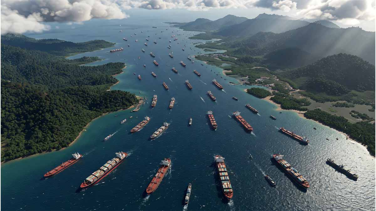
The Strait of Malacca is best understood as a composite passage rather than a single uniform corridor. The operational navigation system that governs the Straits of Malacca and Singapore covers the waters between 100°40′E and 104°23′E under the mandatory ship-reporting system known as STRAITREP, adopted by the International Maritime Organization in 1998. That geographic definition matters because the throughput risk is concentrated not only in the wider Malacca reach but in the tighter, more intensively managed approach toward the Singapore Strait. The same IMO text makes clear that the reporting regime applies to a formally delimited operational area rather than an abstract “sea lane,” which is why disruption analysis has to be route-specific rather than generic.
Its physical constraint is not reducible to width alone. Official EIA analysis states that, at the Phillips Channel in the Singapore Strait, the waterway narrows to about 1.7 miles; official World Bank documentation on the Straits of Malacca and Singapore describes the route as shallow, hazardous to navigation, and characterized by narrow channels, irregular tides, and shifting bottom topography. Those combined conditions are strategically more important than headline width figures because they constrain maneuvering, channel separation, under-keel clearance, and the tolerance for navigational error in one of the densest shipping corridors on earth.
The routeing architecture reflects exactly those constraints. The IMO adopted traffic separation schemes and deep-water routes for the Straits of Malacca and Singapore through Assembly resolutions A.375(X) and A.476(XII), and later formalized the STRAITREP system through MSC.73(69). These instruments are not legal ornament. They are evidence that the strait’s geometry requires managed separation, reporting discipline, and special handling for very large crude carriers and deep-draught vessels. In other words, the corridor is globally important partly because it is navigable only through dense governance and control, not because it is naturally forgiving.
The navigational density at the Singapore end of the corridor is visible in current port-system statistics. The Maritime and Port Authority of Singapore reported that annual vessel arrival tonnage in the Port of Singapore reached a record 3.11 billion gross tonnage in 2024, up from 3.09 billion in 2023. It also reported that the main shipping categories—bulk carriers, container ships, and tankers—each accounted for close to a third of this arrival tonnage and together contributed over 90% of it. That composition is analytically important because it shows that Malacca–Singapore is not specialized around a single trade; it is a multiplex corridor simultaneously serving hydrocarbons, raw materials, and containerized manufactured goods.
Container density reinforces the same point. MPA’s 2024 Annual Report states that Singapore’s container throughput reached 41.12 million TEUs in 2024, surpassing the prior 39.01 million TEUs in 2023 and confirming Singapore’s role as the world’s largest container transshipment hub. It also reports bunker sales of 54.92 million tonnes in 2024, another record. These figures matter for Malacca not because all those boxes or bunker tonnes physically transit the narrowest segment, but because the Singapore node at the strait’s eastern throat converts passage through Malacca into global network connectivity, transshipment, and voyage refueling. A disruption at or near the strait therefore affects both through traffic and the service architecture that keeps long-haul maritime circulation functioning.
The UN Trade and Development record shows why that transshipment role has widened in significance. In its 2025 chapter on international maritime trade, UNCTAD reported that growth in containerized trade in 2024 was observed across all major trade lanes and that the main East–West corridors—East Asia to North America, East Asia to Europe, and Europe to North America—recorded the strongest expansion, with the first two remaining the backbone of global container flows. Because the Malacca–Singapore axis is the principal western maritime gateway from East Asia toward the Indian Ocean and Europe, rising container intensity on those corridors increases the strategic penalty of any delay or closure at the strait.
Hydrocarbon flows add a second, distinct layer of importance. The current EIA world chokepoints page identifies the Strait of Malacca as one of the world’s major oil and LNG transit chokepoints and provides dedicated flow charts for both petroleum and LNG moving through the passage. Earlier EIA analysis quantified petroleum and other liquids transit through the strait at 16 million barrels per day in 2016, with 85%–90% of annual petroleum flows consisting of crude oil. The numerical level has varied over time, but the structural pattern is stable: the corridor is a major intake route for East Asian hydrocarbon demand rather than a marginal byway.
The LNG dimension is often understated, but the official record does not support treating Malacca as an oil-only chokepoint. EIA states that the strait is an important transit route for LNG from Persian Gulf and African suppliers, especially toward East Asia. The current World Oil Transit Chokepoints page includes a dedicated chart for LNG flows through the Strait of Malacca, confirming that the passage remains material to gas security as well as oil security. This matters because LNG trade is even more schedule-sensitive than crude in many consuming systems, given regasification planning, seasonal demand swings, and tighter flexibility in some import portfolios.
A newer and less discussed layer of exposure comes from clean-energy supply chains. In Energy Technology Perspectives 2024, the IEA states that around half of all maritime trade in clean energy technologies passes through the Strait of Malacca. That single data point expands the significance of the corridor beyond fossil fuels and containerized consumer goods. It means the strait is becoming a transport hinge for batteries, solar-related components, and other energy-transition hardware. As a result, a Malacca disruption would not merely hit legacy hydrocarbon systems; it would also slow parts of the material supply chain for the low-emissions transition itself.
For China, the key issue is less whether the strait is important than how deeply import exposure and industrial trade exposure overlap at that location. Official China National Bureau of Statistics data show that China imported 553.42 million tons of crude petroleum oil in 2024, while domestic crude production was 212.82 million tons. That production-import balance underlines persistent external dependence even without assigning a single precise Malacca share to the total. The IEA separately warns in the World Energy Outlook 2024 material that disruption at major chokepoints including Malacca could lead to severe price volatility. For China, therefore, Malacca vulnerability is not simply about physical supply interruption; it is about the possibility that one corridor simultaneously tightens oil availability, shipping schedules, and import costs for the world’s largest trading economy.
For Japan, the exposure is both direct and explicitly recognized in current official strategy. The Agency for Natural Resources and Energy in Japan’s 2025 Strategic Energy Plan states that Japan depends on the Middle East for more than 90% of its crude oil imports and notes that deterioration in the Middle East, where critical choke points are concentrated, has a direct impact on Japan’s energy security. The same ministry’s public energy explainer reiterates that Japan depends on the Middle East for more than 90% of crude oil imports. Because the shortest maritime route from the Middle East to Japan runs through the Indian Ocean, across the Strait of Malacca, and onward into East Asian waters, this is one of the clearest state-level examples of Malacca-linked vulnerability in the official record.
For South Korea, the public official material available in this session is more explicit on gas import dependence than on a Malacca-specific percentage, but the vulnerability structure is still visible. The IEA country page for Korea shows the continued importance of gas imports to the country’s supply mix, and the IEA oil-security page on the Strait of Hormuz states that Japan and Korea are particularly reliant on oil flows passing through that strait. Because a large share of Middle Eastern oil and a significant share of LNG reaching Northeast Asia must continue eastward through the Indian Ocean–Malacca–South China Sea arc, the Korean case fits the same demand-side exposure pattern even where a single official page does not reduce it to one headline Malacca percentage.
The ASEAN picture is more heterogeneous but also more structurally exposed than a casual reading suggests. The IEA’s Southeast Asia Energy Outlook 2024 states that the region is set to become a net importer of gas by the late 2020s and that, under today’s policy settings, its annual oil import bill rises substantially over time. The ASEAN Centre for Energy’s Oil and Gas Updates 2024 adds concrete country-level dependency data, stating that in 2023 oil import dependency was 100% for Singapore, 99% for the Philippines, and 93% for Thailand, with Viet Nam also highly dependent and Malaysia showing a notable rise. This matters because Malacca is not only a corridor serving Northeast Asia; it also underpins the energy metabolism of multiple Southeast Asian states integrated into the same maritime system.
Infrastructure concentration at the eastern end of the passage deepens the strategic stakes. Singapore is not merely adjacent to the chokepoint; it is a dense operating platform built around it. MPA identifies the Vessel Traffic Information System (VTIS) as the core traffic-management system for the Singapore Strait and Singapore port waters, and states that ships in these waters report under STRAITREP to VTIS, which is operated by MPA. That confirms that real-time traffic management, mandatory reporting, and navigational information services are central to keeping the corridor safe and fluid. The chokepoint, in other words, is stabilized by a digital and regulatory operating layer whose effectiveness is now part of global trade resilience.
Governance in the strait is also cooperative rather than singular. An IMO legal document on environmental protection in the Straits of Malacca and Singapore records that a cooperative mechanism on safety of navigation and environmental protection was formally agreed in 2007, designed to facilitate cooperation among the littoral States, user States, and other stakeholders. This is significant because it shows that chokepoint governance here is not reducible to one navy or one port authority. It is a layered regime involving Indonesia, Malaysia, and Singapore, plus the wider user community and IMO rulemaking. That kind of governance can improve resilience against routine risks, but it also means response capacity depends on coordination quality across multiple sovereign and institutional layers.
The security environment is not static. The IMO summary of MSC 110 states that the Straits of Malacca and Singapore were the most affected area globally in 2024 for acts of piracy and armed robbery against ships, with 91 incidents reported. The MSC 109 summary had already identified the same area as the most affected in the first half of 2024, with 37 incidents. These numbers do not imply systemic breakdown, but they do show that the world’s most tightly managed trade corridor still faces persistent low-level maritime security friction. For strategic analysis, that matters because a corridor already burdened by dense traffic and strict navigation control has little tolerance for additional disruption, even below the threshold of interstate conflict.
The surveillance and safety architecture has also evolved technologically over time. The World Bank’s documentation for the Marine Electronic Highway Demonstration Project in the Straits of Malacca and Singapore described the straits as the preferred route between the Persian Gulf and the Far East, noted that alternative routes add several days to the voyage, and linked safer navigation to enhanced maritime safety infrastructure and regulatory mechanisms. While the project documents are older, they remain useful because they show that the current monitoring regime is the product of deliberate infrastructure layering: routeing rules, reporting systems, electronic navigation support, and multinational governance were developed precisely because the corridor could not safely absorb global traffic growth without institutional augmentation.
A practical implication follows from the traffic and port data. When MPA reported in May 2024 that the monthly average tonnage of container vessel arrivals in the first four months of the year had risen to 72.4 million gross tonnage, and later reported 16.90 million TEUs handled in the first five months of 2024, it was describing not an isolated port surge but the visible strain of rerouted and concentrated traffic in the broader regional system. Singapore responded with berth optimization, yard capacity measures, and closer coordination with liners and terminals, showing that Malacca-linked stress often appears first in queueing, transshipment pressure, and scheduling congestion rather than in formal closure.
The strongest high-level conclusion from the official material is that the Strait of Malacca is a compound chokepoint whose global role comes from the overlap of four systems: a constrained hydrographic corridor, a top-tier transshipment complex in Singapore, a large hydrocarbon intake route for East Asia, and a multilayered governance-and-surveillance regime needed to prevent congestion and incident risk from spilling into systemic disruption. The official record supports all four elements independently: physical constraint in EIA, IMO, and World Bank materials; trade concentration in MPA and UNCTAD data; energy exposure in IEA, EIA, Japan METI, China NBS, and ASEAN Centre for Energy sources; and traffic control plus cooperative governance in IMO and MPA documents. Taken together, that makes Malacca not just a narrow passage but a high-centrality operating system for the wider Indian Ocean–East Asia trade complex.
CHAPTER II
The Strait of Malacca in the Global System
Compound chokepoint: Constrained passage + Singapore transshipment hub + East Asia energy lifeline • April 20, 2026
The Strait of Malacca is not a simple narrow passage. It is a high-centrality operating system where physical constraint at the Phillips Channel (1.7 miles), Singapore’s world-leading transshipment and bunkering platform, massive East Asian hydrocarbon and container demand, and multilayered IMO/STRAITREP governance converge. Disruption here simultaneously affects oil security, container scheduling, clean-energy supply chains, and regional economic metabolism.
| ASPECT | KEY DATA (2024) | SOURCE | STRATEGIC IMPLICATION |
|---|---|---|---|
| Physical Constraint | Phillips Channel narrows to 1.7 miles • Shallow, shifting bottom | EIA / World Bank | Limited maneuvering room for deep-draught vessels |
| Container Throughput | 41.12 million TEUs (record) | MPA Singapore | World’s largest transshipment hub at eastern throat |
| Oil Transit | ≈16 million bpd (stable pattern) | EIA | Primary intake valve for East Asian hydrocarbon demand |
| Clean Energy Tech | ≈50% of global maritime trade in clean tech components | IEA Energy Technology Perspectives | Emerging exposure layer for energy transition supply chains |
| Governance | STRAITREP + VTIS + 2007 Cooperative Mechanism | IMO / MPA | Multilateral layered control (Indonesia, Malaysia, Singapore + users) |
| Piracy Incidents | 91 incidents in 2024 (most affected globally) | IMO MSC 110 | Persistent low-level security friction in high-density corridor |
Chapter III – Escalation Pathways and Systemic Risk
The Strait of Malacca does not exist in isolation. In the contemporary maritime system, it functions as a high-centrality node whose disruption would propagate non-linear effects across energy markets, supply-chain synchronization, freight pricing, and geopolitical signaling. Its role as the primary demand-side intake valve for industrial East Asia—handling the largest volume of seaborne oil among global chokepoints—amplifies its systemic fragility, particularly amid cascading pressures from upstream disruptions such as those observed in the Strait of Hormuz.
Empirical data underscore this centrality. According to the U.S. Energy Information Administration (EIA), the Strait of Malacca transited an estimated 23.2 million barrels of oil per day in the first half of 2025, accounting for approximately 29% of total global maritime oil flows and making it the world’s largest oil transit chokepoint. Crude oil and condensate comprised the majority (~16.6 million b/d), with petroleum products adding another layer. Parallel LNG flows reached roughly 9.2 billion cubic feet per day. These volumes exceed those of the Strait of Hormuz and reflect Malacca’s structural position linking Middle Eastern supply basins with the manufacturing cores of China, Japan, South Korea, and broader East Asia. UNCTAD assessments continue to frame roughly one-third of global maritime trade volume as reliant on this corridor, reinforcing its status as a low-redundancy artery in just-in-time logistics networks.
At its narrowest operational segments—particularly the Phillips Channel in the Singapore Strait—the passage constricts to approximately 1.7–2.8 km, creating severe physical constraints on maneuvering, traffic separation, and under-keel clearance for deep-draught vessels. This geometry, combined with high navigational density and the mandatory STRAITREP regime, means that even localized incidents (collision, grounding, or hybrid interference) can generate disproportionate network-wide delays.
Scenario Modeling: Disruption, Blockade, and Hybrid Interference
Three primary escalation archetypes warrant modeling:
- Kinetic or Physical Disruption — A limited blockade, mining, or deliberate incident (e.g., vessel ramming or sabotage) at the narrowest points. Historical analogies include the Red Sea/Bab el-Mandeb disruptions of 2023–2024, where flows dropped over 50%. In Malacca, a multi-week closure would force immediate rerouting, overwhelming alternative Indonesian passages and tying up global tanker and container capacity.
- Hybrid Interference — Non-kinetic tools such as GPS spoofing, cyber attacks on port logistics or Vessel Traffic Information Systems (VTIS), electronic warfare, or coordinated “gray-zone” harassment by state or proxy actors. The Straits of Malacca and Singapore have already recorded the highest global incidents of piracy and armed robbery in 2024 (91 reported cases), illustrating baseline friction that hybrid tactics could exploit or amplify. Simulations of cyber-physical attacks highlight the risk of cascading collisions or simultaneous navigation failures in such a dense corridor.
- Secondary Escalation Trigger — Following major upstream disruption (e.g., prolonged Hormuz closure), adversaries could target Malacca as part of a distributed multi-chokepoint strategy. This “chain-reaction” logic aligns with asymmetric doctrines aimed at imposing system-wide economic costs rather than seeking decisive naval victory in any single theater.
In each scenario, the tightly coupled nature of contemporary logistics—lean inventories, financialized freight markets, and just-in-time manufacturing—converts physical delay into rapid second-order shocks.
Economic Cascade Effects
Disruption at Malacca would trigger non-linear propagation:
- Oil and Energy Price Volatility — With China alone routing a substantial share of its >70% import-dependent oil through the corridor (and ~48% of certain Malacca-transiting imports attributed to China in recent data), even partial restrictions would tighten availability and spike refining margins. IMF and IEA analyses of analogous chokepoint shocks document rapid transmission into broader inflation trajectories, sovereign risk spreads, and derivatives markets.
- Shipping Costs and Freight Markets — Rerouting via alternatives adds hundreds to thousands of nautical miles. A full diversion around the Indonesian archipelago could increase voyage distances significantly, raising bunker fuel consumption, charter rates, and insurance premia. UNCTAD-documented Red Sea reroutings already demonstrated how such shifts elevate global vessel demand (e.g., +3% overall, higher for containers) and extend transit times by days to weeks.
- Broader Macroeconomic Transmission — Higher energy and transport costs feed into manufacturing input prices, consumer goods inflation, and GDP drag—particularly for import-reliant East Asian economies. World Bank and IMF modeling of supply-chain shocks emphasizes sensitivity in tightly optimized networks, where ton-mile increases outpace volume growth.
These effects would compound existing stresses from any concurrent Hormuz disruption, creating compound contagion across energy, trade, and financial channels.
Military-Strategic Implications
Malacca sits at the intersection of great-power maritime competition. The United States Navy maintains forward presence and freedom-of-navigation operations in the Indo-Pacific, while the People’s Liberation Army Navy (PLAN) has expanded its operational reach and domain-awareness capabilities in the region. Littoral states (Indonesia, Malaysia, Singapore) coordinate through the Malacca Strait Patrols (MSP) and cooperative mechanisms established since 2007, which have successfully mitigated piracy but remain calibrated primarily for non-state threats.
State-level hybrid or kinetic scenarios would strain these frameworks. Doctrines of sea denial, anti-access/area-denial (A2/AD), and economic coercion could manifest through submarine operations, long-range strike, or proxy actions. For China, the enduring “Malacca Dilemma” frames the strait as a potential vulnerability in any high-intensity contingency (e.g., over Taiwan), where external actors could constrain energy lifelines. Deterrence models here emphasize credible forward presence, alliance signaling, and rapid restoration capacity rather than absolute invulnerability.
Alternative Routes and Their Limitations
Malacca’s substitutability is low under stress. Primary alternatives include:
- Sunda Strait — Shallower, narrower in sections, with strong currents, sandbanks, and navigational hazards. Unsuitable for many ultra-large crude carriers and very large crude carriers (VLCCs).
- Lombok Strait (and onward via Makassar) — Deeper and wider than Sunda, preferred for super-tankers, but adds substantial distance (estimates range from ~1,800–3,000+ km extra, or 2.5–4.5+ days) and increases fuel and time costs by 20% or more. Capacity constraints and additional chokepoint risks (e.g., archipelagic sea lanes governance) limit scalability.
- Longer Routes — Around the full Indonesian archipelago or hypothetical Arctic/Northern Sea Route options remain even less viable for routine high-volume flows due to seasonality, ice risks, and infrastructure gaps.
- Overland Pipelines — Limited options (e.g., Myanmar–China) handle only marginal volumes and cannot substitute for maritime scale.
Rerouting would require more tonnage to maintain throughput, exacerbate port congestion (e.g., at Singapore or East Asian hubs), and inflate global shipping demand—precisely the dynamics observed in recent Suez/Red Sea diversions, where ton-miles grew faster than trade volume.
Five Mutually Exclusive Explanatory Frameworks
Malacca’s emergence as a crisis node can be interpreted through competing lenses, each implying different probability weights and policy responses. Bayesian updating with fresh intelligence remains essential:
- Energy Security Driver — Middle East escalation (e.g., Hormuz) prompts downstream targeting to maximize pain on Asian importers.
- Great Power Competition Driver — U.S.–China rivalry extends to control or denial of Indo-Pacific sea lanes, with Malacca as a leverage point in broader deterrence.
- Network Fragility Driver — Cumulative stress across linked chokepoints (Hormuz → Malacca) triggers cascading failure in a low-redundancy system.
- Hybrid Warfare Driver — Non-kinetic or gray-zone tools (cyber, GPS spoofing, legal/economic pressure) exploit governance seams without crossing into open conflict.
- Economic Coercion Driver — Deliberate use of chokepoint leverage for strategic bargaining or punishment, amplifying financial contagion.
These frameworks are not exhaustive but highlight distinct causal pathways and intervention points.
Conclusion
The Strait of Malacca is a central fault line in the 21st-century global order—not merely because of its physical narrowness or throughput volume, but because it concentrates import dependency for the world’s most dynamic manufacturing region within a tightly coupled, low-substitutability network. Disruption here would generate multi-domain cascades: energy price shocks, logistics desynchronization, freight inflation, and geopolitical realignment. As upstream tensions (e.g., Hormuz) persist and great-power competition intensifies, Malacca’s managed security environment—built on littoral cooperation, MSP patrols, and digital governance—faces tests it was not primarily designed to withstand.
Policymakers and market actors must therefore treat Malacca not as a static geographic feature but as a dynamic systemic node whose resilience depends on diversified routing options, hardened infrastructure, improved hybrid-threat defenses, and transparent multilateral coordination. In an era of stacked dependencies, the stabilization of Malacca may prove as decisive to global stability as the management of any single upstream chokepoint.


