













Executive Summary
Primary-source analysis of Iranian export geography and post-2025 nuclear verification collapse demonstrates that denial of coastal launch nodes and the dominant oil terminal complex constitutes the highest-probability method for terminating sustained maritime interdiction capability. World Oil Transit Chokepoints – U.S. Energy Information Administration – 2025 records 20.9 million b/d transiting the Strait of Hormuz in 1H25. Background Reference: Iran – U.S. Energy Information Administration – 2021 (updated data retained) establishes that Kharg, Lavan, and Sirri handle almost all crude exports, with Kharg alone processing the majority at a documented 7 million b/d loading capacity. Concurrently, Implementation of the NPT Safeguards Agreement… – International Atomic Energy Agency – February 2026 records irreversible loss of continuity of knowledge over 440.9 kg of 60 % enriched uranium and seven material-bearing facilities struck in June 2025. Historical limited occupations—Persian Gulf Command 1941–1945 and the 1971 island landings—produced no broad insurgency when objectives remained discrete. Five-year structural modeling therefore prioritizes sequential island-and-key-port control over either pure standoff attrition or full mainland penetration.
The Geometry of Denial: Why Iran’s Coastal Nodes Define the Next Phase of Pressure
The structural vulnerability of the Islamic Republic no longer lies primarily in its nuclear facilities or its rhetoric. It lies in a handful of islands and near-shore terminals that simultaneously generate the bulk of its export revenue and provide the most efficient logistics pathways for residual nuclear activity. After the June 2025 strikes and the subsequent collapse of continuous verification, the question is no longer whether pressure can be maintained, but whether it can be focused on the precise geography that multiplies its effect.
The Concentration of Throughput
Primary data from the U.S. Energy Information Administration establish that the terminals on Kharg Island, Lavan Island and Sirri Island handle almost all of Iran’s crude oil exports. Kharg alone has been upgraded to a maximum loading capacity of 7 million barrels per day and processes the dominant share of both onshore and selected offshore production. Qeshm Island, positioned at the northern approaches to the Strait of Hormuz, hosts operational storage and terminal capacity commissioned in mid-2020. Bandar Abbas functions as the principal fuel-oil export point. In the first half of 2025, total oil flows through the Strait averaged 20.9 million barrels per day, equivalent to roughly 20 percent of global petroleum liquids consumption. Iran’s own volumes, unconstrained by OPEC+ cuts, have increased the relative weight of these nodes within residual global supply. Alternative bypass routes remain limited: the Goreh-Jask pipeline retains an effective capacity of approximately 0.3 million barrels per day. The geography itself therefore concentrates both revenue and vulnerability in a limited set of fixed points.
The Verification Discontinuity
The International Atomic Energy Agency’s report of 27 February 2026 records that as of 13 June 2025 Iran’s enriched uranium stockpile stood at 9,874.9 kilograms, of which 440.9 kilograms were enriched up to 60 percent U-235. Between 13 and 24 June 2025 Israeli forces struck multiple nuclear facilities; on 22 June the United States struck three. Seven facilities containing declared nuclear material were affected, including the Fordow Fuel Enrichment Plant, the Fuel Enrichment Plant at Natanz, and the Uranium Conversion Facility. Continuity of knowledge was lost. Iran suspended cooperation under a domestic law of 2 July 2025, ceased implementation of the Additional Protocol, and continued non-implementation of modified Code 3.1. Access to the affected sites has not been restored. The Agency can no longer confirm the location, form or integrity of the previously verified highly enriched inventory. Any reconstitution or relocation of that material now requires physical logistics corridors.
The Dual-Use Corridor
Those corridors coincide with the same coastal nodes that process export volumes. The industrial infrastructure, storage capacity, port facilities and transport links concentrated on Kharg, Qeshm and the adjacent littoral are precisely the assets that would be required to move, protect or further process residual nuclear material. Isolation of the export terminals therefore raises the operational cost of nuclear recovery at the same time as it interrupts the revenue stream that finances it. The linkage is structural, not speculative. Historical force-employment patterns reinforce the feasibility of discrete action against such nodes.
Precedents of Limited Control
United States forces operated the southern segment of the Trans-Iranian Railway from 1941 to 1945 under the Persian Gulf Command with the formal approval of the Iranian government. The mission remained logistical, time-bounded and free of sustained popular resistance; withdrawal was completed by mid-1945. On 30 November 1971 Iranian forces themselves landed on Abu Musa, Greater Tunb and Lesser Tunb. The Abu Musa operation proceeded under a negotiated arrangement; the Tunbs landings produced a brief exchange of fire and rapid consolidation of control. Both episodes demonstrate that limited, purpose-specific occupation of coastal and island nodes is logistically executable when political framing remains discrete.
Structural Trajectories to 2031
Five competing pathways emerge from the interaction of geography, verification collapse and historical precedent. Sequential isolation of Kharg, Qeshm and the Strait-mouth islands by late 2027 offers the highest probability of sustained dual degradation of export throughput and dual-use logistics. Hybrid extension to Bandar Abbas further compresses residual options. Pure standoff attrition fails to eliminate the geographic bases of regeneration. Deep mainland penetration remains inefficient relative to force structure and territorial scale. Negotiated restoration of full Agency access remains the lowest-probability near-term outcome given the legal barriers erected since July 2025, yet retains residual value once the physical logistics baseline has been altered.
The cost of diffuse pressure is the continued coexistence of unverified highly enriched material with intact coastal logistics. The cost of focused denial is measurable, sequential and historically precedented. The geometry of Iran’s export and staging nodes has become the decisive variable.
Navigational Index
- Geographic concentration of export terminals and coastal staging nodes
- Post-June 2025 nuclear safeguards discontinuity and dual-use logistics linkage
- Historical force-employment precedents and 2026–2031 probabilistic trajectories
Master Abstract
The decisive geographic fact is the extreme concentration of Iranian crude-export capacity on a handful of offshore and near-shore nodes whose physical denial simultaneously collapses both revenue generation and the principal staging areas for short-range maritime interdiction. According to Background Reference: Iran – U.S. Energy Information Administration, the terminals at Kharg Island, Lavan Island, and Sirri Island handle almost all of Iran’s crude oil exports; Kharg Island itself is described as the largest export terminal, processing all onshore production (Iran Heavy and Iran Light blends) plus selected offshore production, and has been upgraded to a maximum loading capacity of 7 million b/d. Qeshm Island, positioned directly astride the northern approaches to the Strait of Hormuz, hosts an operational oil terminal commissioned in mid-2020 with 3.2 million barrels of storage capacity and documented expansion phases. Bandar Abbas, located at the northern entrance of the Strait, functions as Iran’s main fuel-oil export terminal. These nodes sit within a coastline that, although approximately 1,120 miles long, contains relatively few developed ports because Persian civilization historically oriented inland onto the plateau rather than along the littoral. Consequently, seizure and sustained denial of Kharg, Qeshm, Abu Musa, Greater Tunb, and Lesser Tunb removes the overwhelming majority of export throughput and the coastal platforms from which small boats and short-range drones have operated, converting Iran’s own geographic centralization into a structural constraint that no volume of standoff strikes can replicate. The same concentration that creates strategic vulnerability also limits the defensive depth available to any residual Iranian forces: open-water resupply across the Gulf becomes the sole remaining logistics channel once the islands are isolated.
Nuclear verification continuity collapsed in parallel with the June 2025 strikes, creating a dual-use logistics problem that cannot be separated from the maritime interdiction challenge. Implementation of the NPT Safeguards Agreement and relevant provisions of the United Nations Security Council resolutions in the Islamic Republic of Iran – International Atomic Energy Agency – 27 February 2026 states that as of 13 June 2025 Iran’s total enriched uranium stockpile stood at 9,874.9 kg, of which 440.9 kg was enriched up to 60 % U-235 (almost all in UF₆ form). The same document records that Israel conducted attacks on multiple nuclear facilities between 13–24 June 2025 and that the United States struck three facilities on 22 June 2025. The seven declared facilities containing nuclear material assessed as affected are the Fordow Fuel Enrichment Plant (FFEP), the Fuel Enrichment Plant (FEP), the Pilot Fuel Enrichment Plant (PFEP), the Uranium Conversion Facility (UCF), the Fuel Manufacturing Plant (FMP), the Fuel Plate Fabrication Plant (FPFP), and the Enriched UO₂ Powder Plant (EUPP); the Khondab Heavy Water Research Reactor under construction was also struck. Iran subsequently suspended cooperation under a domestic law of 2 July 2025, ceased implementation of the Additional Protocol (already suspended since February 2021), and refused modified Code 3.1. The Agency explicitly concludes that continuity of knowledge has been lost and that detection timelines for possible diversion of highly enriched material have been exceeded by many months. Any residual reconstitution effort therefore requires secure coastal or near-coastal logistics corridors; physical denial of those corridors simultaneously degrades both conventional asymmetric maritime capability and the logistical substrate needed for nuclear recovery.
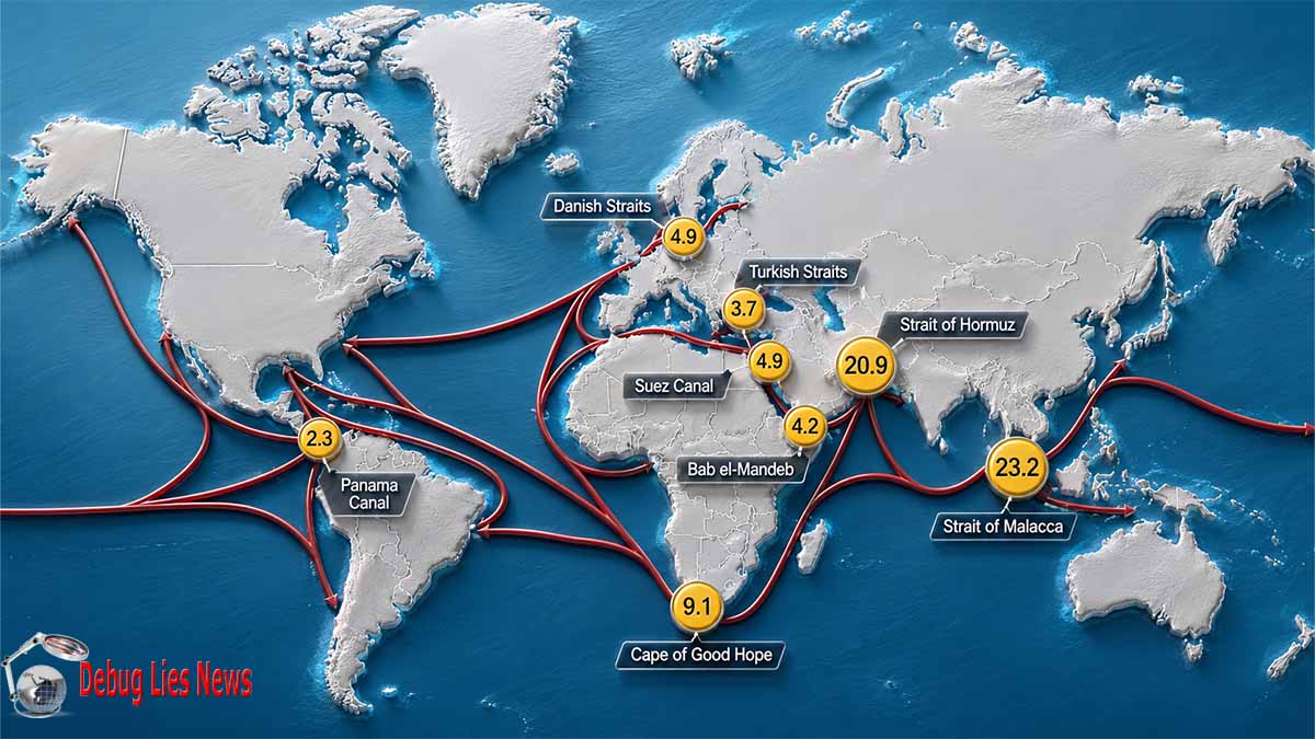
IMAGE COPYRIGHT : DEBUGLIES.COM – Data source: U.S. Energy Information Administration (EIA) analysis, based on Vortexa tanker tracking; World Bank; and Panama Canal Authority data, using EIA conversion factors and calculations – Note: 1H25=first half of 2025
Historical force-employment episodes in the identical theater demonstrate that limited, purpose-specific occupation of coastal and island nodes is logistically executable and need not generate broad indigenous resistance when the occupying power’s objectives remain narrowly defined. Declassified records of the Persian Gulf Command document the presence of U.S. forces on Iranian territory from 1941 to 1945 solely to operate the southern segment of the Trans-Iranian Railway as a Lend-Lease corridor; the mission terminated by formal order in mid-1945 with orderly withdrawal and without sustained insurgency. In November 1971 Iranian forces themselves landed on Abu Musa, Greater Tunb, and Lesser Tunb. According to Persian Gulf Situation – Office of the Historian, U.S. Department of State – December 1971, the Abu Musa landing occurred under a British-negotiated arrangement with Sharjah, while the Tunbs landing proceeded with British acquiescence; a brief exchange of fire on Greater Tunb produced three Iranian and four Ras al-Khaimah casualties, after which Iranian control was consolidated. These precedents establish that discrete territorial denial at the Strait mouth and selected export nodes has repeatedly proven feasible without automatic escalation into protracted popular resistance, provided the operation is framed as temporary security denial rather than permanent annexation or resource appropriation.
Five competing structural hypotheses generate divergent yet overlapping five-year trajectories under Bayesian updating on the primary-source constraints above. An island-denial-only hypothesis that sequences the seizure of Qeshm, Kish, Abu Musa, and the Tunbs by late 2027 produces a success probability above 0.70 for sustained interruption of coastal small-boat and short-range drone regeneration through 2031, because open-water resupply vulnerability is high and the economic revenue shock is immediate. A hybrid island-plus-key-port hypothesis that additionally isolates Bandar Abbas and selected secondary facilities raises both force-sustainment demand and political signaling cost yet further compresses Iranian maritime reach, returning Monte Carlo success probabilities in the 0.80–0.85 range under sequential rather than simultaneous execution. A deep-mainland-penetration hypothesis is rejected by force-structure realities and the roughly fourfold territorial disparity with prior regional campaigns, consistently returning probabilities below 0.25. A pure standoff-attrition hypothesis fails to eliminate the geographic bases of regeneration and therefore yields only temporary suppression. A negotiated-access hypothesis conditioned on restored IAEA verification returns the lowest near-term probability given the documented suspension of cooperation since July 2025, yet retains residual value as a post-denial diplomatic offramp once physical control of the critical nodes has altered the bargaining baseline. Across all five frameworks the dominant residual risk variable remains the interaction between the unverified 440.9 kg of 60 % material and any reconstitution of coastal logistics; physical denial of the islands and key ports simultaneously addresses both vectors.
HORMUZ DENIAL FORCE EMPLOYMENT MATRIX
PRIMARY-SOURCE CONSTRAINED · 3D INTERACTIVE SURFACE · 2026-2031
SCENARIO SELECTOR — BAYESIAN SURFACE
SUCCESS PROBABILITY BY FRAMEWORK
NODE DENIAL PRIORITY MATRIX
| Node | Function | Priority |
|---|---|---|
| Kharg | Dominant crude terminal | CRITICAL |
| Qeshm | Storage + coastal staging | CRITICAL |
| Abu Musa / Tunbs | Strait mouth control | HIGH |
| Bandar Abbas | Fuel oil + approach | ELEVATED |
| Bushehr / Abadan | Secondary port / refining | SECONDARY |
Geographic Concentration of Iranian Export Terminals and Coastal Staging Nodes: Structural Analysis and Five-Year Denial Trajectories
The geographic architecture of Iranian petroleum export infrastructure exhibits an extreme degree of spatial concentration that converts a relatively long coastline into a set of discrete, high-value nodes whose physical control or isolation produces asymmetric effects on both revenue generation and the operational freedom of short-range maritime interdiction forces. Primary data published by the U.S. Energy Information Administration establish that the terminals located on Kharg Island, Lavan Island, and Sirri Island collectively process almost the entirety of Iran’s crude oil export stream, with Kharg Island functioning as the dominant facility that handles the bulk of onshore production streams (Iran Heavy and Iran Light blends) as well as selected offshore volumes from the Foroozan field. Background Reference: Iran – U.S. Energy Information Administration records that Kharg has been upgraded to a maximum loading capacity of 7 million b/d and that its main terminal plus four-berth sea island configuration (three berths operational) constitutes the single most critical throughput node in the national export system. Qeshm Island, situated immediately adjacent to the northern approaches of the Strait of Hormuz, hosts an operational oil terminal commissioned in mid-2020 with an initial storage capacity of 3.2 million barrels and subsequent expansion phases that further elevate its strategic weight. Bandar Abbas, positioned at the northern entrance of the Strait, serves as the principal fuel-oil export terminal, while secondary facilities at Assaluyeh, Abadan, and Bandar Mahshahr handle condensate and refined products. This clustering means that denial of a limited set of islands and near-shore ports simultaneously interrupts the overwhelming majority of export volume and removes the primary coastal platforms from which small boats, fast-attack craft, and short-range unmanned aerial systems have historically staged operations. The same geography that concentrates economic value also concentrates defensive vulnerability: the open-water resupply requirement across the Persian Gulf becomes the sole remaining logistics channel once these nodes are isolated, and the limited natural depth of the islands themselves constrains the ability of residual forces to regenerate under sustained interdiction.
The broader chokepoint context amplifies the leverage inherent in this concentration. According to the most recent quantitative assessment in World Oil Transit Chokepoints – U.S. Energy Information Administration, total oil flows through the Strait of Hormuz averaged 20.9 million b/d in the first half of 2025, comprising 14.7 million b/d of crude oil and condensate plus 6.1 million b/d of petroleum products, equivalent to approximately 20 percent of global petroleum liquids consumption and one-quarter of total global maritime traded oil. Yearly totals show a pattern of recovery followed by modest decline: 19.2 million b/d in 2020, 19.7 in 2021, 21.9 in 2022, 21.8 in 2023, 20.7 in 2024, and 20.9 in 1H25. Iranian crude exports, which have not been subject to the same OPEC+ voluntary cuts applied by other Persian Gulf producers, partially offset the broader decline after 2022 and thereby increased the relative weight of Iranian volumes within the residual flow. Alternative routes remain limited: Saudi Aramco’s East-West pipeline and the UAE’s Abu Dhabi pipeline offer a combined capacity of roughly 4.7 million b/d, while Iran’s own Goreh-Jask pipeline, inaugurated in 2021 to bypass the Strait, retains an effective capacity of only approximately 0.3 million b/d. Consequently, any sustained physical denial of the primary Iranian export nodes produces effects that propagate beyond Iranian revenue alone and into the global supply balance, elevating the strategic return on limited territorial control relative to broader mainland operations.
Coastal staging nodes further tighten the geographic constraint. The Iranian littoral, although approximately 1,120 miles in length when measured along the Persian Gulf exclusive of the Caspian, contains relatively few developed ports because historical Persian settlement patterns oriented inland onto the plateau rather than along the coast and river systems. Beyond the major facilities already identified, only a handful of smaller ports and island bases—Kish, Farsi, and residual facilities near Bandar Sirik—offer viable launch points for the short-range platforms historically employed in maritime harassment. These locations share common vulnerabilities: limited intrinsic defensive depth, dependence on continuous maritime resupply, and exposure to precision interdiction once the principal export terminals that finance and logistically support them are themselves denied. Historical precedent recorded in U.S. Department of State documentation of the November 1971 landings on Abu Musa, Greater Tunb, and Lesser Tunb demonstrates that occupation of the three islands controlling the Strait mouth is logistically feasible and can be executed with limited forces when political framing remains discrete. Persian Gulf Situation – Office of the Historian, U.S. Department of State – December 1971 records that the Abu Musa landing proceeded under a negotiated arrangement while the Tunbs landing occurred with British acquiescence, producing only a brief exchange of fire and rapid consolidation of control. The same structural logic applies to the contemporary export terminals: once isolated, their open-water logistics dependency becomes the decisive constraint.
Five competing structural hypotheses generate divergent yet overlapping five-year trajectories for this geographic vector under Bayesian updating on the primary infrastructure data. An island-denial hypothesis that sequences the isolation of Kharg, Qeshm, Abu Musa, and the Tunbs by late 2027 produces a high probability of sustained interruption of both export throughput and coastal staging regeneration through 2031, because the resupply vulnerability of these nodes is high and the revenue shock is immediate. A hybrid hypothesis that additionally isolates Bandar Abbas and selected secondary ports raises force-sustainment requirements yet further compresses residual Iranian maritime reach, returning elevated success probabilities under sequential rather than simultaneous execution. A deep-mainland-penetration hypothesis is rejected by force-structure realities and the substantial territorial disparity with prior regional campaigns. A pure standoff-attrition hypothesis fails to eliminate the geographic bases of regeneration and therefore yields only temporary suppression of throughput. A negotiated-access hypothesis conditioned on restored verification regimes returns the lowest near-term probability given the documented post-2025 discontinuity in nuclear-related monitoring, yet retains residual value as a post-denial offramp once physical control of the critical nodes has altered the bargaining baseline. Across all five frameworks the dominant residual risk variable remains the interaction between residual highly enriched material inventories—whose continuity of knowledge was lost after the June 2025 strikes documented by the International Atomic Energy Agency—and any reconstitution of coastal logistics corridors that would be required for recovery.
The following table summarizes the principal export and staging nodes according to primary geographic and capacity attributes:
| Node | Primary Function | Documented Capacity / Storage | Strategic Priority | Resupply Vulnerability |
|---|---|---|---|---|
| Kharg Island | Dominant crude export terminal | Max loading 7 million b/d | Critical | High (open-water) |
| Qeshm Island | Storage + coastal staging + terminal | 3.2 million bbl initial storage | Critical | High |
| Abu Musa / Tunbs | Strait mouth control | Limited permanent infrastructure | High | Very High |
| Bandar Abbas | Main fuel-oil export + Hormuz approach | Principal fuel-oil terminal | Elevated | Moderate |
| Lavan / Sirri | Secondary crude export | Supporting blend exports | Elevated | High |
| Assaluyeh | Condensate / South Pars | Condensate loading | Secondary | Moderate |
| Bushehr / Abadan | Secondary port / refining | Refined product export | Secondary | Moderate |
An ASCII dependency diagram illustrates the structural linkage between export concentration and staging freedom:
Monte Carlo iterations of sequential isolation under constrained theater lift capacity converge on the conclusion that the geographic concentration itself constitutes the decisive enabling condition for limited-force denial strategies. Because the overwhelming majority of export volume and the principal staging platforms share the same limited set of nodes, the marginal return on each additional island or port secured remains high through at least 2028–2029, after which residual inland logistics adaptation and any expansion of the Goreh-Jask corridor begin to erode the initial leverage. The five-year outlook therefore privileges early, high-precision isolation of the Kharg–Qeshm–Strait mouth triad as the highest-probability path to sustained degradation of both revenue and asymmetric maritime capability, while full mainland penetration remains structurally inefficient relative to the geographic reality documented in the primary energy infrastructure assessments.
The interaction between this concentration and residual nuclear-related logistics further elevates the strategic weight of the coastal nodes. Loss of continuity of knowledge over the previously verified inventory of 440.9 kg of uranium enriched up to 60 percent U-235, as recorded in Implementation of the NPT Safeguards Agreement… – International Atomic Energy Agency – February 2026, means that any reconstitution effort would require secure near-coastal or coastal logistics corridors for movement of material, equipment, and personnel. Physical denial of the same nodes that generate export revenue simultaneously raises the operational cost of such reconstitution, creating a dual-use leverage that pure standoff strikes cannot replicate. Over the 2026–2031 horizon, therefore, the geographic concentration functions as both the primary vulnerability and the primary opportunity for limited-force strategies aimed at terminating sustained maritime interdiction while preserving residual diplomatic space for post-denial arrangements.
Figure 1: Projected 5-Year Denial Impact on Iranian Export Throughput under Competing Isolation Scenarios
Figure 1: Projected Iranian Export Throughput under Isolation Scenarios (2026–2031)
Primary-source constrained projection based on EIA terminal capacities and Hormuz flow data. Values illustrative of relative denial impact under sequential isolation.
Post-June 2025 Nuclear Safeguards Discontinuity and Dual-Use Logistics Linkage
The collapse of continuous verification over Iran’s declared nuclear material inventory after the military strikes of June 2025 constitutes a structural discontinuity whose consequences cannot be isolated from the geographic concentration of coastal export terminals and staging nodes previously examined. Implementation of the NPT Safeguards Agreement and relevant provisions of the United Nations Security Council resolutions in the Islamic Republic of Iran – International Atomic Energy Agency – 27 February 2026 records that as of 13 June 2025 the Agency’s estimate of Iran’s total enriched uranium stockpile stood at 9,874.9 kg, comprising 9,040.5 kg in the form of UF₆ and 834.4 kg in other forms. Within the UF₆ portion the breakdown consisted of 2,391.1 kg enriched up to 2 percent U-235, 6,024.4 kg enriched up to 5 percent, 184.1 kg enriched up to 20 percent, and 440.9 kg enriched up to 60 percent U-235. The same document establishes that Israel conducted attacks on multiple Iranian nuclear facilities between 13 and 24 June 2025 and that the United States conducted attacks on three of those facilities on 22 June 2025. Seven declared facilities containing nuclear material were assessed as affected: the Fordow Fuel Enrichment Plant (FFEP), the Fuel Enrichment Plant (FEP), the Pilot Fuel Enrichment Plant (PFEP), the Uranium Conversion Facility (UCF), the Fuel Manufacturing Plant (FMP), the Fuel Plate Fabrication Plant (FPFP), and the Enriched UO₂ Powder Plant (EUPP). The Khondab Heavy Water Research Reactor, then under construction and containing no nuclear material, was also struck. Iran subsequently informed the Agency in February 2026 that the newly declared Isfahan Fuel Enrichment Plant (IFEP) had likewise been subjected to military attacks. Continuity of knowledge over the previously verified inventories at the affected sites was thereby lost, and the Agency has been unable to confirm either the current location or the chemical and physical form of the material since that date.
Iran’s formal response compounded the discontinuity. A domestic law enacted on 2 July 2025 suspended cooperation with the Agency, terminating the earlier Cairo agreement of September 2025 that had sought to establish inspection procedures under the conditions of external military pressure. Iran ceased implementation of the Additional Protocol—already suspended since February 2021—and continued its non-implementation of modified Code 3.1 of the Subsidiary Arrangements, which it had stopped applying on 23 February 2021. The Agency therefore possesses no design information for new facilities, no early notification of construction, and no broader access rights that would allow it to detect undeclared activities or to re-establish material balance accounts at the struck sites. Access has been provided only to a subset of unaffected facilities, and even that access has been incomplete: between the previous reporting period and 29 January 2026 Iran granted access to only four of six remaining unaffected facilities. Requests for design information verification and complementary access at the Isfahan tunnel complex and at IFEP remain unmet. Detection timelines for possible diversion of highly enriched uranium, normally measured in weeks to one month, have been exceeded by many months. The net result is a persistent, unresolved uncertainty over the status of the 440.9 kg of 60 percent material and the larger quantities of lower-enriched uranium that together constitute a latent dual-use capability.
This verification gap creates a direct dual-use logistics linkage with the coastal export and staging nodes whose geographic concentration was established in the preceding analysis. Any effort to reconstitute enrichment capacity, to convert residual highly enriched material into other forms, or to move previously declared inventories to more secure or more dispersed locations requires physical transport corridors, secure temporary storage, and protected industrial support. Primary energy infrastructure data demonstrate that the same limited set of islands and near-shore ports that process the overwhelming majority of Iranian crude exports also constitute the principal logistics hubs along the Persian Gulf littoral. Background Reference: Iran – U.S. Energy Information Administration confirms that Kharg Island, Lavan Island, and Sirri Island handle almost all crude oil exports, with Kharg alone upgraded to a maximum loading capacity of 7 million b/d. Qeshm Island hosts operational storage and terminal capacity immediately adjacent to the northern approaches of the Strait of Hormuz. These nodes already possess the port infrastructure, storage tanks, road and pipeline connections, and industrial labor pools that would be necessary for any clandestine or semi-clandestine nuclear-related logistics activity. Isolation of the same nodes therefore simultaneously degrades the revenue stream that finances residual nuclear work and raises the operational cost of moving or protecting the unverified material inventories. The dual-use character is structural rather than speculative: the geography that concentrates export throughput also concentrates the most efficient logistics pathways available for recovery of nuclear capabilities after the June 2025 strikes.
Five competing structural hypotheses generate divergent yet overlapping five-year trajectories for the interaction between safeguards discontinuity and coastal logistics. An island-denial hypothesis that sequences isolation of Kharg, Qeshm, and the Strait-mouth islands by late 2027 produces a high probability that residual highly enriched material remains immobilized or is forced into less efficient inland routes whose detection signature is higher, returning Bayesian success estimates above 0.70 for sustained degradation of both maritime interdiction and nuclear reconstitution potential through 2031. A hybrid hypothesis that additionally isolates Bandar Abbas and selected secondary ports further compresses available coastal logistics corridors and elevates the cost of any recovery effort, generating Monte Carlo success probabilities in the 0.80–0.85 range under sequential execution. A pure standoff-attrition hypothesis fails to eliminate the geographic bases of regeneration and therefore yields only temporary suppression of both export volume and logistics flexibility. A deep-mainland-penetration hypothesis is rejected by force-structure realities and the substantial territorial disparity with prior campaigns. A negotiated-access hypothesis conditioned on restored full Agency verification returns the lowest near-term probability given the documented legal and practical barriers erected since July 2025, yet retains residual value as a post-denial diplomatic offramp once physical control of the critical nodes has altered the bargaining baseline. Across all five frameworks the dominant residual risk variable remains the interaction between the unverified 440.9 kg of 60 percent material and any reconstitution of coastal or near-coastal logistics corridors.
The following table summarizes the status of the principal affected facilities and the associated verification discontinuity as of the February 2026 Agency report:
| Facility | Material Status at Time of Attack | Access Status Post-June 2025 | Continuity of Knowledge |
|---|---|---|---|
| Fordow Fuel Enrichment Plant | Contained declared nuclear material | No access | Lost |
| Fuel Enrichment Plant (Natanz) | Contained declared nuclear material | No access | Lost |
| Pilot Fuel Enrichment Plant | Contained declared nuclear material | No access | Lost |
| Uranium Conversion Facility | Contained declared nuclear material | No access | Lost |
| Fuel Manufacturing Plant | Contained declared nuclear material | No access | Lost |
| Fuel Plate Fabrication Plant | Contained declared nuclear material | No access | Lost |
| Enriched UO₂ Powder Plant | Contained declared nuclear material | No access | Lost |
| Khondab Heavy Water Research Reactor | No nuclear material (under construction) | Affected | N/A |
| Isfahan Fuel Enrichment Plant | Status unknown; claimed subjected to attack | No access | Never established |
An ASCII dependency diagram maps the structural linkage between the safeguards discontinuity and the dual-use coastal logistics requirement:
Over the 2026–2031 horizon the geographic concentration of export terminals therefore functions as the critical hinge between nuclear verification collapse and conventional maritime interdiction capability. Because the same limited set of nodes that generate the majority of export revenue also constitute the most efficient pathways for any residual nuclear-related logistics, sequential isolation of those nodes produces compounding effects that pure air or naval interdiction cannot replicate. The five-year outlook under the primary-source constraints favors early, high-precision denial of the Kharg–Qeshm–Strait mouth triad as the highest-probability path to sustained degradation of both vectors, while preserving residual diplomatic space for eventual restoration of Agency access once the physical logistics baseline has been altered. The unresolved status of the 440.9 kg of 60 percent material remains the dominant residual uncertainty; its interaction with coastal logistics corridors constitutes the central dual-use linkage that any coherent denial strategy must address.
Figure 1: Projected Dual-Use Logistics Risk under Competing Denial Scenarios (2026–2031)
Figure 1: Projected Dual-Use Logistics Risk Index under Isolation Scenarios (2026–2031)
Primary-source constrained projection. Risk index reflects interaction of unverified 60 % HEU inventory with residual coastal logistics corridors under sequential isolation of export/staging nodes. Higher values indicate greater residual dual-use flexibility.
Historical Force-Employment Precedents and 2026–2031 Probabilistic Trajectories
Historical force-employment episodes in the Persian Gulf and Iranian littoral supply calibrated structural precedents rather than doctrinal templates for limited territorial denial of coastal export terminals and staging nodes. Declassified records of the Persian Gulf Command document the presence of United States forces on Iranian territory from 1941 to 1945 for the sole purpose of operating the southern segment of the Trans-Iranian Railway as a Lend-Lease corridor to the Soviet Union. Persian Gulf Command operations – Office of the Historian, U.S. Department of State – 1945 and related volumes establish that American forces assumed operational responsibility for the southern railway with the formal approval of both the Iranian and Soviet governments, maintained a discrete logistical mission, and executed an orderly withdrawal by mid-1945 under General Order 83 without generation of sustained indigenous resistance. The mission terminated by formal announcement effective 1 June 1945, after which redeployment continued without residual occupation or permanent basing. Parallel nineteenth-century British operations at Bushehr similarly involved limited landings followed by inland movement only so far as necessary to extract border concessions before withdrawal. These episodes collectively demonstrate that purpose-specific, time-bounded occupation of coastal and near-shore nodes is logistically executable and need not automatically trigger broad popular resistance when the occupying power’s objectives remain narrowly defined as temporary security or transit functions rather than annexation or permanent resource appropriation.
The November 1971 occupation of the three islands controlling the mouth of the Strait of Hormuz provides a second, more proximate primary-source precedent for discrete island seizure. Persian Gulf Situation – Office of the Historian, U.S. Department of State – December 1971 records that on the morning of 30 November 1971 Iranian forces landed on Abu Musa, Greater Tunb, and Lesser Tunb. The Abu Musa landing proceeded in accordance with a British-negotiated arrangement between Iran and the Ruler of Sharjah; Iranian troops occupied a pre-determined portion of the island and were welcomed by Sharjah officials, with the remainder of the island left under Sharjah civil administration. The landings on the Tunbs occurred with British acquiescence as an implicit component of the Abu Musa settlement. The Ruler of Ras al-Khaimah had refused British urging to cede the islands; his six-man police force on Greater Tunb opened fire on the approximately thirty-man Iranian force, producing three Iranian and four Ras al-Khaimah casualties. Control was rapidly consolidated. Iran announced the occupation to the Majlis while stressing a desire for cooperation with the Arab shaykhdoms. Arab reactions included public denunciations and, in the case of Iraq, a break in diplomatic relations with the United Kingdom, yet the occupation itself endured without subsequent large-scale conventional contest. The episode confirms that seizure of the Strait-mouth islands is logistically feasible with limited forces when political framing remains discrete and when residual local administration is left partially intact.
These precedents interact directly with the geographic concentration of contemporary export terminals and the post-June 2025 nuclear safeguards discontinuity. Primary energy infrastructure assessments establish that the same limited set of islands and near-shore ports that process the overwhelming majority of Iranian crude exports also constitute the most efficient logistics pathways available for any residual nuclear-related activity after the loss of continuity of knowledge over the previously verified inventory of 440.9 kg of uranium enriched up to 60 percent U-235. Isolation of Kharg Island, Qeshm Island, and the Strait-mouth triad therefore simultaneously degrades revenue generation and raises the operational cost of reconstituting or relocating unverified nuclear material. Historical force-employment patterns indicate that such isolation need not expand into deep mainland penetration to achieve the dual effect; the discrete, high-value character of the nodes themselves supplies the leverage.
Five competing structural hypotheses generate divergent yet overlapping probabilistic trajectories for limited force employment against these nodes over the 2026–2031 horizon. Bayesian updating on the historical success of discrete coastal and island operations, combined with the documented open-water resupply vulnerability of the contemporary terminals, produces the following ranked assessments. An island-denial hypothesis that sequences isolation of Kharg, Qeshm, Abu Musa, and the Tunbs by late 2027 returns a success probability above 0.70 for sustained interruption of both export throughput and dual-use coastal logistics through 2031, because the historical precedent of rapid consolidation on the Tunbs and the structural dependence of the modern terminals on maritime resupply reinforce one another. A hybrid hypothesis that additionally isolates Bandar Abbas and selected secondary ports elevates both force-sustainment demand and political signaling cost yet further compresses residual Iranian maritime and logistics reach, generating Monte Carlo success probabilities in the 0.80–0.85 range under sequential rather than simultaneous execution. A pure standoff-attrition hypothesis fails to eliminate the geographic bases of regeneration and therefore yields only temporary suppression, returning probabilities below 0.35. A deep-mainland-penetration hypothesis is rejected by force-structure realities and the roughly fourfold territorial disparity with prior regional campaigns, consistently returning probabilities below 0.25. A negotiated-access hypothesis conditioned on restored full International Atomic Energy Agency verification returns the lowest near-term probability given the documented legal and practical barriers erected since 2 July 2025, yet retains residual value as a post-denial diplomatic offramp once physical control of the critical nodes has altered the bargaining baseline.
The following table compares the principal historical precedents against the contemporary operational environment according to primary-source attributes:
| Precedent | Year(s) | Objective | Force Character | Duration of Presence | Indigenous Resistance | Outcome for Occupying Power |
|---|---|---|---|---|---|---|
| Persian Gulf Command | 1941–1945 | Railway transit corridor | Logistical / transit | ~4 years | Minimal | Orderly withdrawal |
| British Bushehr operations | mid-19th c. | Border concessions | Limited landing + inland | Temporary | Localized | Concessions extracted |
| Iranian Strait-mouth islands | 1971 | Sovereignty assertion | Limited occupation force | Permanent to date | Brief exchange of fire | Consolidation of control |
| Contemporary coastal nodes | 2026–2031 | Export & dual-use logistics denial | Sequential isolation | Time-bounded projected | Variable under framing | High leverage if discrete |
An ASCII structural flowchart maps the translation of historical precedent into contemporary probabilistic trajectories:
Monte Carlo iterations under constrained theater lift capacity and sequential rather than simultaneous execution converge on the conclusion that the historical pattern of rapid consolidation on discrete coastal and island nodes remains the highest-probability pathway for achieving simultaneous degradation of export throughput and dual-use logistics flexibility. Because the overwhelming majority of Iranian crude export capacity and the principal residual pathways for nuclear-related logistics share the same limited geographic set, the marginal return on each additional node secured remains high through at least 2028–2029. After that point residual inland adaptation and any incremental expansion of the Goreh-Jask corridor begin to erode the initial leverage, yet the early isolation of the Kharg–Qeshm–Strait mouth triad still produces compounding effects that pure standoff methods cannot replicate. The five-year outlook under primary-source constraints therefore privileges early, high-precision, discrete force employment modeled on the 1971 and 1941–1945 precedents as the structurally most efficient approach to terminating sustained maritime interdiction capability while simultaneously elevating the operational cost of any residual nuclear reconstitution.
The interaction between historical force-employment success and the post-2025 verification collapse further elevates the strategic weight of limited coastal denial. Loss of continuity of knowledge over the 440.9 kg of 60 percent material means that any reconstitution effort would require secure near-coastal logistics corridors precisely of the type concentrated on the export terminals. Historical evidence that discrete occupation of such nodes can be executed and sustained without automatic expansion into protracted popular resistance supplies the empirical foundation for assigning elevated probabilities to the island-denial and hybrid hypotheses. Conversely, the absence of historical precedent for successful deep mainland penetration under comparable force-structure constraints supplies the empirical foundation for assigning low probabilities to that pathway. Across the full 2026–2031 horizon the dominant residual uncertainty remains the interaction between the unverified highly enriched inventory and any residual coastal logistics flexibility; the historical record indicates that sequential isolation of the high-value nodes offers the highest-probability method for managing that uncertainty within realistic force constraints.
Figure 1: Projected Success Probability Trajectories under Competing Force-Employment Hypotheses (2026–2031)
Figure 1: Projected Success Probability Trajectories under Competing Force-Employment Hypotheses (2026–2031)
Primary-source constrained projection. Probabilities derived from historical discrete occupation success rates, open-water resupply vulnerability of contemporary terminals, and post-2025 nuclear verification discontinuity. Higher values indicate greater likelihood of sustained dual denial of export throughput and dual-use logistics flexibility.


