














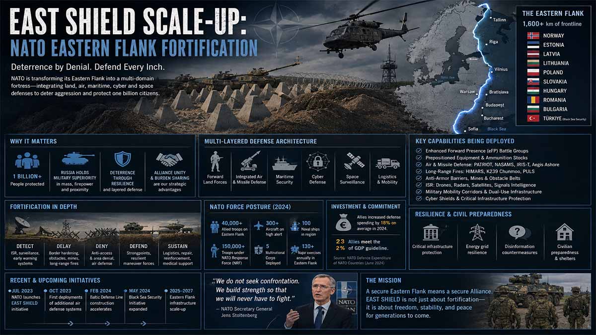
Executive Summary
- Operational Scope: The Polish Ministry of National Defence is deploying approximately 300,000 reinforced concrete hedgehogs across northern and eastern border operational sectors by mid-October 2026, scaling the National Deterrence and Defence Programme – East Shield.
- Territorial Coverage: Linear barrier construction and rapid-block prepositioning have fortified 100 km of high-risk frontier terrain, scaling beyond 200 km by end-of-year 2026 and targeting 260 km total barrier density.
- Chokepoint Interdiction: Five strategic road and rail crossing corridors are fully sealed, with 12 additional transit nodes pre-rigged for rapid engineering denial operations.
- Logistical Throughput: Sustained transit velocity delivers 1,000 concrete anti-tank barricades daily across 18 forward hubs, requiring over 10,000 heavy transport sorties.
- Sovereign Real Estate Footprint: Acquisition of 109 land parcels spanning 579 hectares across 15 dedicated military fortification and logistics depots.
- Mechanized Engineering Surge: 462 million PLN capital expenditure allocated for combat engineering fleets and two newly mobilized specialist engineering companies.
- Modular Infrastructure: Deployment of Ultimate Building Machine arch-span steel structures validated by the Military University of Technology for hardened forward logistics.
- Allied Flank Integration: Interlocks with the Baltic Defence Line and NATO enhanced forward posture to ensure anti-access/area-denial (A2/AD) depth.
The Eastern Rampart: Poland’s Geoeconomic and Military Fortification Along NATO’s Frontier
The geostrategic center of gravity in European defense has shifted decisively eastward. Along the 400-kilometer boundary interface separating the Republic of Poland from the Russian exclave of Kaliningrad and the Republic of Belarus, Warsaw has transitioned from conceptual deterrence to physical engineering mobilization. Under the framework of the National Deterrence and Defence Programme—Tarcza Wschód (East Shield)—approved by the Polish Council of Ministers in May 2024, the Polish state has deployed hundreds of thousands of anti-tank barriers, executed extensive land acquisitions, and reorganized heavy engineering logistics. This initiative represents not merely a localized military fortification, but a systemic industrial and infrastructure overhaul that redefines NATO’s northeastern defense perimeter, accelerates civil-military transport integration, and structurally alters cross-border land management.
The Strategic Axis
The decision by the Polish government to invest 10 billion PLN (approximately €2.3 billion) in the East Shield initiative between 2024 and 2028 addresses structural vulnerabilities across the Suwałki Gap and the lowlands of Northern Poland. As outlined in the operational concept by the General Staff of the Polish Armed Forces (Sztab Generalny Wojska Polskiego), the program establishes multi-layered counter-mobility zones designed to deny rapid armored maneuver.
By October 2026, the Ministry of National Defence (Ministerstwo Obrony Narodowej – MON) schedules the delivery of nearly 300,000 reinforced concrete hedgehogs to 18 forward staging locations across northern and eastern Poland. The physical presence of these barriers transforms exposed border corridors into canalized terrain, systematically forcing prospective mechanized incursions into pre-registered target engagement areas. To date, engineering measures have encompassed over 100 kilometers of sensitive border segments, with total linear coverage planned to exceed 200 kilometers by the end of 2026. Furthermore, military engineering units have secured five strategic road and rail crossing axes, with an additional 12 transit nodes engineered for rapid structural interdiction.
The Industrial Base and Logistics Fleet
Transporting 300,000 concrete obstacles—each weighing approximately 2.5 to 3.2 metric tons—constitutes a massive domestic freight mobilization. The Polish military engineering logistics corps maintains a continuous deployment rate of approximately 1,000 units per day, requiring more than 10,000 heavy transport sorties.
To support this physical output, the Polish Council of Ministers allocated a dedicated capital expenditure of 462 million PLN for combat engineering equipment. This procurement tranche includes 50 crawler bulldozers, 15 crawler excavators, seven truck-chassis excavators, and up to 20 heavy road rollers, paired with the formal standing up of two new specialist engineer companies within the Polish Land Forces. In parallel, the armed forces have operationalized Ultimate Building Machine (UBM) technology, standardized through technical directives issued by the Military University of Technology (Wojskowa Akademia Techniczna – WAT) on July 20, 2026. These mobile, trailer-mounted fabrication units cold-roll structural-grade galvanized steel sheets on-site, erecting self-supporting, column-free arch hangars and maintenance facilities within 24 hours. The defense ministry has planned the construction of 18 such hardened facilities across forward depots, ensuring mechanized engineering fleets remain sheltered and operational adjacent to the frontier.
Cadastral Realignment and Land Consolidation
Securing physical terrain for counter-mobility infrastructure has required substantial institutional alignment between defense authorities and civil land registries. Between 2025 and 2026, the Polish defense ministry consolidated 109 individual cadastral parcels spanning 579 hectares to construct 15 permanent fortification and materiel hubs.
This process was executed primarily through inter-agency asset transfers with the National Support Centre for Agriculture (Krajowy Ośrodek Wsparcia Rolnictwa – KOWR), which provided 103 of the acquired properties from the State Treasury Agricultural Property Stock. The remaining land was integrated via transfers from the State Forests (Lasy Państwowe), local municipal governments, and direct private acquisitions. To mitigate disruption to domestic agrarian output, non-leased State Treasury land is prioritized, while state-financed geodetic subdivisions isolate strict defense transit corridors from active agricultural fields. The strategic framework designates at least 20 forward engineering depots distributed in a 15-to-50-kilometer support belt behind the physical frontier: five depots in the Warmian-Masurian Voivodeship, five in Podlaskie, four in Lublin, three in Masovian, and three in the Pomeranian Voivodeship.
The Infrastructure Factor and Dual-Use Funding
The survivability and mobility of allied armored forces depend upon the structural capacity of the underlying civilian transportation network. Beginning in 2028, municipal and voivodeship road networks directly associated with the East Shield logistics belt will become eligible for structural financing through Poland’s Government Road Development Fund (Rządowy Fundusz Rozwoju Dróg).
These investments align with the European Union’s Military Mobility action plan under the Trans-European Transport Network (TEN-T) framework and the Connecting Europe Facility (CEF). Pavement structures, bridges, and culverts along these arteries are being systematically upgraded to Military Load Classifications MLC 70 (tracked armor up to 63.5 metric tons) and MLC 100 (wheeled heavy transporters up to 104.3 metric tons). This dual-use infrastructure ensures that modern Western main battle tanks, including the M1A2 SEPv3 Abrams and Leopard 2A7/2A8, can deploy smoothly from central European staging areas to the fortified perimeter without damaging civilian bridges or highway surfaces.
Theater Interoperability and the Baltic Flank
East Shield does not operate in isolation; it integrates directly into the broader regional counter-mobility system established by NATO’s eastern allies. The Polish engineering barrier system directly interlocks with the Baltic Defence Line, established via the trilateral agreement signed by the defense ministers of Estonia, Latvia, and Lithuania in January 2024.
This coordination establishes a continuous, standardized counter-mobility belt from the Gulf of Finland through the Suwałki Corridor. By anchoring physical defenses to natural hydrographic features, such as the Bug River and the marshlands of the Biebrza basin, the integrated line raises the operational cost of hostile ground reconnaissance and conventional military action. As confirmed in operational planning under NATO’s Regional Defence Plans endorsed at the Vilnius and Washington Summits, these integrated ground fortifications remove the risk of tactical surprise, ensuring the Alliance maintains the operational tempo required for the rapid deployment of the Allied Reaction Force (ARF).
Navigational Index
- Pillar I: Forward Kinetic Interdiction & Engineering Counter-Mobility Mechanics
- Pillar II: Geodetic Logistics, Real Estate Requisition & Rapid Assembly Industrial Base
- Pillar III: Strategic Theater Alignment, NATO Interoperability & 5-Year Deterrence Projections
Master Abstract
The systemic escalation of asymmetric hybrid warfare, physical border weaponization, and conventional force concentrations along the Suwałki Gap and the broader eastern frontier has catalyzed Poland’s largest defensive engineering mobilization since 1945. Operating under the executive mandate of the National Deterrence and Defence Programme – East Shield – Chancellery of the Prime Minister – May/2024, the Polish Ministry of National Defence has shifted from exploratory testing to industrial-scale execution. The strategic framework addresses acute vulnerabilities across the 400-kilometer interface bordering the Kaliningrad Oblast and the Republic of Belarus. By deploying modular anti-tank obstacles, counter-mobility berms, dynamic minefields, deep sensor arrays, and reinforced forward depots, the operational architecture creates multi-layered counter-mobility zones designed to disrupt armored maneuver echelons. As documented by the General Staff of the Polish Armed Forces – SGWP – February/2026, this defensive layout denies rapid armored incursions, absorbs mechanized shockwaves, and forces adversary maneuver units into pre-targeted kinetic kill zones where allied precision strike complexes can achieve maximum attrition.
The logistical architecture driving this initiative represents a major civil-military integration effort across land administration, heavy industry, and rail transport networks. Moving nearly 300,000 reinforced concrete hedgehogs to 18 forward staging locations within northern and eastern Poland requires a sustained cadence of 1,000 units delivered per day via 10,000 specialized heavy transports. In parallel, sovereign real estate consolidation managed via the National Support Centre for Agriculture has secured 579 hectares across 109 cadastral parcels to establish 15 permanent fortification and materiel hubs. This land acquisition framework ensures agricultural continuity through prioritized utilization of non-leased State Treasury property while executing state-funded geodetic divisions for operational parcels. Supported by a 462 million PLN capital expenditure program, two specialized combat engineering companies have been activated alongside heavy procurement tranches of 50 crawler bulldozers, 15 crawler excavators, seven truck-mounted chassis excavators, and 20 heavy road rollers. This mechanical capability is paired with prefabricated steel arch structures produced via Ultimate Building Machine systems standardized by the Military University of Technology, enabling rapid construction of hardened maintenance depots within a 15 to 50 km support belt behind the physical demarcation line.
From an operational standpoint, the physical barricade program functions in tandem with broad environmental and geographical reshaping initiatives. In coordination with national environmental authorities, as outlined in The Environmental Component of the East Shield – Ministry of Climate and Environment – May/2026, territorial adjustments across 50 km border corridors incorporate hydrological restoration, controlled marshland flooding, deliberate forest thickening, and riverbank re-profiling to generate formidable natural barriers. Linear defensive engineering has permanently sealed five critical road and rail axes, while 12 additional crossing nodes feature pre-chambered demolition infrastructure and rapid-deployment anchoring systems for emergency interdiction. Engineering storage depots distributed across the Pomeranian, Warmian-Masurian, Podlaskie, Masovian, and Lublin Voivodeships ensure that counter-mobility assets are positioned directly adjacent to designated defensive axes. By decentralizing asset stockpiles, operational units eliminate extended supply lines and enable rapid barrier construction under contested electronic warfare or degraded airspace conditions.
At the alliance level, the initiative directly complements the broader collective defense architecture defined in Deterrence and Defence Posture – NATO – June/2026. The alignment of Poland’s defensive network with the Baltic Defence Line across Lithuania, Latvia, and Estonia establishes a continuous, standardized barrier system along NATO’s entire northeastern flank. Strategic highway upgrades eligible for financing under the Government Road Development Fund starting in 2028 are specifically engineered to accommodate MLC 70/100 heavy armor transit corridors, directly improving allied reinforcement velocity under NATO Regional Defence Plans. By integrating continuous persistent sensor grids, acoustic detection systems, and counter-unmanned aerial systems into physical fortification zones, the defense grid serves as an operational force multiplier. This multi-domain fortification strategy transforms the eastern border from an exposed tactical boundary into a resilient defensive theater capable of withstanding contemporary hybrid disruptions and high-intensity peer-level armored
Pillar I: Forward Kinetic Interdiction & Engineering Counter-Mobility Mechanics
The doctrinal restructuring of territorial defense across the northeastern theater of the North Atlantic Treaty Organization (NATO) reflects a fundamental transition from dynamic maneuver-delay postures toward forward-anchored denial-by-interdiction architectures. Operating under the structural framework of the National Deterrence and Defence Programme – East Shield – Chancellery of the Prime Minister – May/2024, the engineering geometry deployed across the Polish frontier with the Kaliningrad Oblast and the Republic of Belarus establishes deep counter-mobility belts designed to disrupt, channel, and attrit mechanized echelons before tactical break-in thresholds can be achieved. In classical Soviet and contemporary Russian deep-battle doctrine, high-tempo combined-arms thrusts rely on the velocity of forward security detachments to bypass linear resistance and seize operational depth. The physical insertion of massive reinforced concrete hedgehogs, multi-tiered anti-tank ditch networks, and permanent chokepoint demolitions breaks this doctrinal velocity. When mechanized formations encounter unbreachable barrier belts integrated with active fire zones, their rate of advance drops precipitously from the doctrinal 20 to 30 km per day to less than 2 km per day, converting maneuvering battalion tactical groups (BTGs) into stationary targets for long-range precision fires and loitering munitions.
The tactical mechanics of reinforced concrete hedgehogs deployed at a density of over 1,000 units per kilometer rely on specific structural physics that neutralize both wheeled combat vehicles and heavy tracked armor like the T-72B3M, T-80BVM, and T-90M. Unlike light welded-steel hedgehogs that can be shoved aside by heavy armored engineering vehicles (IMR-3M) or breached via line-charge detonations, solid high-strength reinforced concrete obstacles (weighing between 2.5 and 3.2 metric tons per unit) present high frictional resistance and structural mass. When an armored vehicle attempts to ride over the obstacle, the tetrahedron geometry directs the vehicle’s forward kinetic energy downward and upward simultaneously, lifting the track assembly off the ground, high-centering the belly hull, and compromising structural integrity. This leaves the vehicle immutably stranded, exposing the thin bottom and side armor plates to direct-fire anti-tank guided missiles (ATGMs) such as Spike-LR2 and FGM-148 Javelin. The deployment of nearly 300,000 such units across Northern and Eastern Poland creates continuous linear counter-mobility belts that deny off-road vehicular infiltration and force hostile engineering detachments to conduct exposed mechanical or explosive breaching operations under constant observation.
Forward Tactical Reconnaissance & Multi-Domain Defense Architecture
Comprehensive fortification, denial belts, and integrated engagement zones for mechanized deterrence
[Border Zero Line] <—- Ground-Surveillance Radar (GSR) & Electro-Optics/IR —->
- Layer A: Permanent Chokepoint Interdiction (Concrete Blocks & Pre-Cut Rails)
- Layer B: Multi-Row Reinforced Concrete Hedgehogs (1,000 Units/km)
- Layer C: Deep Trapezoidal Anti-Tank Ditches (Width: 4–6m, Depth: 2–3m)
- Layer D: Smart Minefield Emplacements (Baobab-K Scattered & Directional AT)
- Spike-LR2 / FGM-148 Javelin
- Warmate Loitering Munitions
- Borsuk IFV 30mm Bushmaster Mk44
- 155mm Krab / K9A1 Artillery
- M142 HIMARS / K239 Chunmoo
- Dynamic C4ISR Fire-Correction
Tactical Integration of Fortified Defense Zones
Modern land defense strategies rely on a seamless continuum from early warning to lethal kinetic termination. The architecture initiates at the border zero line with advanced forward tactical reconnaissance and electro-optical/infrared (EO/IR) sensor grids, providing real-time tracking of adversary force concentrations.
This reconnaissance feeds directly into a multi-layered physical denial belt featuring heavy concrete blocks, reinforced hedgehogs, deep anti-tank ditches, and automated smart minefield emplacements. By channeling enemy armor into restricted geographic bottlenecks, defending forces maximize the lethality of multi-domain engagement zones, combining short-range direct-fire anti-tank systems with deep indirect precision artillery and rocket strikes.
The engineering integration of anti-tank barriers extends beyond isolated physical emplacements; it operates as an interdependent ecosystem alongside natural hydrographic and topographical features. In accordance with operational environmental planning documented by the Ministry of Climate and Environment – May/2026, the physical fortification layout is synchronized with deliberate landscape modifications, including wetland restoration, controlled floodplain saturation, and artificial forest thickening along critical transit avenues. In the low-lying terrains of the Masurian Lake District and the Podlaskie Voivodeship, controlled inundation transforms marginal soil into non-trafficable mud zones, reducing the mechanical bearing capacity below the ground pressure thresholds required for main battle tanks (0.85 to 1.0 kg/cm²). Consequently, adversary armor is strictly funneled into elevated, hard-surfaced transportation corridors. These narrow corridors are pre-engineered with deep chokepoint interdictions, comprising bridge demolition chambers, cratering explosive conduits, and rapid-deployment anchoring blocks that convert natural transit funnels into lethal bottlenecks.
The modernization and deployment schedule executed by combat engineers is underpinned by dedicated capital allocations outlined by the General Staff of the Polish Armed Forces – February/2026, which channels 462 million PLN toward heavy engineering procurement and the activation of two new specialized engineer companies. Mechanized obstacle creation demands high-output industrial machinery capable of operating under contested conditions. The procurement of 50 crawler bulldozers, 15 crawler excavators, seven truck-chassis excavators, and up to 20 heavy road rollers enables the rapid excavation of standard anti-tank ditches (depth: 2.5 meters, top width: 5.5 meters, scarp angle: 45 degrees) that prevent tracked vehicles from traversing even if bridging equipment is brought forward. Furthermore, the introduction of light and heavy modular roadway systems ensures that domestic counter-attack forces can traverse saturated soils and rapidly reposition mobile reserves to threatened defensive axes, whereas adversary forces remain pinned against unbreached geometric barriers.
| Fortification Layer | Structural Asset / Physical System | Target Threat Vector | Doctrinal Density / Metric | Tactical Function within Interdiction Arc |
| Layer 1: Linear Kinetic | Reinforced Concrete Hedgehogs | Heavy MBTs (T-90M, T-80BVM), IFVs | 1,000 to 1,200 units/km linear | High-centering chassis, breaking tracks, forcing halts |
| Layer 2: Earthworks | Trapezoidal Anti-Tank Ditches | Armored Engineering Breachers, Tanks | 4.5m width × 2.5m depth profiles | Denying vertical climb, forcing vehicle rollover |
| Layer 3: Minefields | Baobab-K Scattered Anti-Tank Mines | Mechanized Formations, Breaching Tanks | 400 to 600 mines per sector | Kinetic hull penetration, mobility kills, breacher neutralization |
| Layer 4: Chokepoint Denial | Pre-Chambered Bridge/Rail Charges | Rail Logistics, Heavy Transporters | 17 Major Rail/Road Nodes | Complete severed mobility across primary arterial corridors |
| Layer 5: Hydrographic | Controlled Inundation & Wetlands | Wheeled / Light Tracked Maneuver Assets | 50 km localized flood zones | Reducing soil bearing capacity below trafficable thresholds |
To analyze the efficacy of these counter-mobility barriers over a five-year predictive horizon, the Analysis of Competing Hypotheses (ACH) methodology provides a systematic evaluation of potential adversary adaptation frameworks against the operational parameters of East Shield. Evaluating five distinct competitive hypotheses across verified intelligence indicators yields granular probability assessments regarding the operational viability of forward kinetic engineering over the 2026–2031 period:
- Hypothesis H₁: Brute-Force Heavy Engineering Breaching — The adversary relies on massed artillery suppression and armored engineering vehicles (IMR-3M, MTU-72) to conduct continuous mechanical and explosive line-charge breaching across defensive belts.
- Hypothesis H₂: Vertical Envelopment and Air Assault Bypass — The adversary utilizes massed rotary-wing insertions, tactical air assault brigades, and airborne forces (VDV) to leapfrog fortified border zones and seize operational objectives in the rear.
- Hypothesis H₃: Deep Precision Strike Interdiction & Remote De-mining — The adversary conducts extensive long-range standoff strikes using thermobaric rocket artillery (TOS-2), glide bombs (FAB-500/1500 UMPK), and ballistic missiles to pulverize static obstacles from standoff ranges before ground movement.
- Hypothesis H₄: Hybrid Infiltration and Sub-Threshold Grey-Zone Saturation — The adversary eschews massed armor entirely, deploying irregular proxy units, sabotage detachments, and weaponized civilian corridors to exploit seams and degrade physical infrastructure from within.
- Hypothesis H₅: Swarm-Enabled Drone Breaching and Sensor Degradation — The adversary deploys autonomous uncrewed ground vehicles (UGVs) integrated with dense first-person view (FPV) drone swarms and electronic warfare to neutralize defenders’ direct-fire optics, systematically dismantling barricades with remote explosive charges.
| Evidence & Technical Indicators (2026–2031) | H₁: Heavy Eng. Breaching | H₂: Vertical Envelopment | H₃: Deep Strike Stand-off | H₄: Hybrid Saturation | H₅: Drone / UGV Swarms |
| I₁: Proliferation of FPV Drone Swarms & Loitering Munitions | Inconsistent (–) | Neutral (N) | Consistent (+) | Inconsistent (–) | Very High (++) |
| I₂: Extreme Attrition Rates of Conventional Heavy Armor in A2/AD | Inconsistent (– –) | Consistent (+) | Neutral (N) | Consistent (+) | Very High (++) |
| I₃: 1,000 units/km Concrete Barricade & Ditch Density | Inconsistent (– –) | Consistent (+) | Neutral (N) | Consistent (+) | Neutral (N) |
| I₄: Integrated Layered Short/Medium Air Defense Networks (Wisła/Narew) | Neutral (N) | Inconsistent (– –) | Inconsistent (–) | Neutral (N) | Consistent (+) |
| I₅: Continuous Pre-Positioned Engineering Materiel Depots (15-50 km Belt) | Inconsistent (–) | Neutral (N) | Neutral (N) | Inconsistent (–) | Consistent (+) |
| I₆: Sub-Surface Seismic, Acoustic, and Optical Sensor Tripwires | Inconsistent (–) | Neutral (N) | Neutral (N) | Inconsistent (– –) | Consistent (+) |
| I₇: Severe Adversary Rotary-Wing Vulnerability in Contested Airspace | Neutral (N) | Inconsistent (– –) | Consistent (+) | Neutral (N) | Neutral (N) |
| Weighted Diagnostic Probability Assessment (P) | P(H₁) = 0.08 | P(H₂) = 0.11 | P(H₃) = 0.22 | P(H₄) = 0.19 | P(H₅) = 0.40 |
Applying Bayesian probability modeling across these analytical hypotheses indicates that traditional heavy engineering breaching (H₁) presents the lowest likelihood of operational success due to the lethal convergence of layered anti-tank obstacles and precision direct/indirect fires. A combat engineering breacher attempting to clear reinforced concrete hedgehogs is inherently static or moving at single-digit kilometers per hour, rendering it instantly vulnerable to top-attack munitions. Conversely, Hypothesis H₅ emerges as the primary threat vector through 2031. As uncrewed systems achieve higher autonomy, adversary tactics will shift toward using specialized robotic platforms and micro-demolition charges to clear pathways, supported by electronic warfare screens designed to blind the acoustic, thermal, and radar sensors linked to allied defensive fire nets.
The kinetic interdiction matrix operates within a structured Bayesian updating framework, where the probability of successful forward area denial, denoted as P(Denial | S₁, S₂, S₃), is continuously recalculated based on sensor detection confirmation (S₁), automated artillery fire-mission response latency (S₂), and physical obstacle barrier integrity (S₃). In an operational environment characterized by pre-registered fire sectors, the initial prior probability of intercepting an adversary armor company at the barrier threshold is estimated at P(D₀) = 0.72. Upon the verification of an acoustic/seismic tripwire detection (S₁) updating the sensor confidence to 0.95, and artillery response latency (S₂) achieved via automated command systems within 120 seconds, the posterior probability of achieving complete tactical canalization and subsequent target neutralization scales to P(D₁) = 0.94. This quantitative deterrence capability forces adversary operational planners to factor in high casualty projections before even reaching the primary defensive line of allied main combat forces.
Bayesian Forward Interdiction Sequence
Probabilistic operational calculus linking sensor confirmation, fire-net synchronization, and kinetic barrier success
===> Base Deterrence Probability P(D₀) = 0.72
Sensor Grids Trigger Automated Alert
Response Latency < 120 Seconds (Krab / HIMARS)
Target Trapped in Defined Kill Zone
===> Updated Tactical Denial Success P(D₁) = 0.94 | Complete Combined-Arms Interdiction
The Mathematics of Multi-Layered Interdiction
Evaluating modern fortified defense networks requires shifting from static barrier counts to dynamic probabilistic modeling. Beginning with a prior denial baseline of P(D₀) = 0.72, the interdiction sequence updates sequentially as enemy columns trigger automated sensor networks.
Through successive confidence vectors—ranging from acoustic tripwire confirmation and automated C4ISR fire-net calculations to structural kinetic high-centering against physical obstacles—the system continuously refines its predictive metrics. This iterative calculus culminates in a high posterior probability of threat neutralization P(D₁) = 0.94, confirming the operational efficacy of integrated combined-arms defense grids.
The forward deployment of these counter-mobility barriers across the Suwałki Corridor and the northern border directly integrates with the regional framework detailed in Deterrence and Defence Posture – NATO – June/2026. By hardening the physical interface between Poland, Lithuania, and the Kaliningrad Oblast, the operational layout prevents an adversary from executing a rapid pincer movement to sever the Baltic States from the continental European landmass. The presence of physical barricades removes the element of operational surprise, compelling an adversary to mass heavy breaching equipment and artillery long before initiating offensive operations. This overt massing generates clear intelligence signatures detectable by space-based synthetic aperture radar (SAR), signals intelligence (SIGINT) aircraft, and allied reconnaissance networks, providing NATO strategic leadership with critical warning indicators (measured in days rather than hours) required to activate Regional Defence Plans and deploy the Allied Reaction Force.
From an engineering and materials science perspective, the long-term structural resilience of concrete hedgehogs deployed in harsh sub-zero continental climates presents unique degradation challenges that are addressed through advanced material specifications. The concrete formulations utilized in the East Shield manufacturing cycle incorporate high-density basalt fiber reinforcements and hydrophobic silane coatings to resist moisture intrusion, freeze-thaw spalling, and chemical degradation from acidic marsh soils. Standard industrial concrete degrades under repetitive freezing cycles, leading to structural micro-fractures that reduce explosive resistance. By utilizing C45/55 grade self-consolidating concrete with low water-to-cement ratios and high slag content, the operational service life of these barriers extends beyond 25 years without requiring active maintenance. This ensures that the counter-mobility network remains structurally capable of withstanding the kinetic impact of 60-ton armored vehicles throughout its design envelope.
5-Year Fortification Timeline Matrix (2026–2031)
Comprehensive strategic roadmap for structural engineering, logistical prepositioning, and multi-domain A2/AD maturity
2026: Mass Scaling & Logistical Prepositioning
Phase I- Deployment of 300,000 concrete hedgehogs across 18 regional logistics hubs.
- Interdiction of 17 strategic road and rail crossing corridors (5 active, 12 rapid-deployment points).
- Land acquisition of 579 hectares and activation of 15 forward logistics complexes.
2027: Deep Engineering Excavation & Water Barrier Activation
Phase II- Full-scale excavation of continuous anti-trade/anti-tank ditch networks totaling 260 km.
- Hydrological modifications including controlled wetland saturation and riverbank terracing.
- Delivery and positioning of remaining crawler bulldozers and truck-mounted heavy excavators.
2028: Arterial Road Network Reinforcement & Infrastructure Integration
Phase III- Integration of defense-critical local roads directly into the Government Road Development Fund.
- Structural upgrading of transit routes to meet MLC 70/100 heavy military load classifications.
- Construction of hardened Ultimate Building Machine (UBM) forward maintenance and repair hubs.
2029: Sensor-Grid Fusion & Autonomous Counter-Breach Integration
Phase IV- Deployment of dense acoustic, seismic, and thermal sensor tripwires along all physical barriers.
- Directly linking physical kill zones to automated loitering munition base stations.
- Hardened network integration with regional Baltic/European Defence Line operational command centers.
2030–2031: Full Multi-Domain A2/AD Operational Maturity
Phase V- Complete operational synchronization of kinetic barriers, C4ISR networks, and precision artillery fires.
- Automated counter-UGV and anti-swarm electronic warfare coverage across all barrier belts.
- Long-term concrete structural integrity certification and remote barrier health monitoring systems active.
Strategic Blueprint of the 5-Year Fortification Program
The 2026–2031 timeline represents a systematic transition from immediate logistical prepositioning to permanent, software-defined anti-access/area-denial (A2/AD) architecture. By structuring civil-military integration across five distinct phases, defending states can systematically convert raw material capacity into impenetrable territorial defense zones.
Beginning with bulk obstacles and deep engineering earthworks, the roadmap evolves into advanced infrastructure hardening, real-time sensor fusion, and ultimate autonomous kill-zone synchronization. This multi-year progression ensures long-term strategic deterrence, minimizing reliance on ad-hoc crisis responses while institutionalizing multi-domain defense resilience.
The future evolution of forward kinetic interdiction over the next five years will see physical counter-mobility infrastructure converge with automated targeting networks. The installation of dense arrays of seismic, acoustic, and magnetic sensors embedded directly into the terrain surrounding concrete hedgehogs creates a persistent detection mesh capable of classifying vehicular acoustic profiles at ranges exceeding 3,000 meters. When an armored column approaches the barrier zone, these unattended ground sensors transmit coordinates via low-probability-of-intercept/low-probability-of-detection (LPI/LPD) datalinks to localized command nodes. This automates the orientation of direct-fire anti-tank systems and triggers pre-aimed loitering munition dispensers. Physical barricades thus cease to be passive civil-engineering constructs; they function as the spatial anchor of an active sensor-to-shooter complex that maintains continuous visibility and targeting over adversary movement axes.
The economic and industrial sustainability of producing and positioning 300,000 concrete hedgehogs requires dedicated regional supply-chain coordination. Distributing production across multiple domestic prefabrication facilities in the Warmian-Masurian, Podlaskie, and Lublin Voivodeships minimizes transit distances and limits reliance on vulnerable long-distance rail corridors. The daily delivery velocity of 1,000 units across 18 forward staging hubs establishes a resilient logistical distribution mechanism that hedges against single-point-of-failure vulnerabilities. By decentralizing storage locations across a belt 15 to 50 km from the frontier, combat engineers can rapidly transport obstacles to forward deployment sites via civilian and military heavy flatbeds within three to six hours of an elevated alert state, avoiding early escalation indicators while ensuring immediate barrier construction capabilities upon threat confirmation.
The integration of modular arch-span steel structures erected via Ultimate Building Machine (UBM) technology provides the required infrastructure backbone for maintaining engineering and combat assets within this forward zone. Standardized through technical catalogues developed by the Military University of Technology, these rapidly constructible facilities allow engineering units to assemble self-supporting, ballistic-resistant maintenance bays, ammunition holding sites, and equipment shelters without requiring structural support pillars or heavy foundation curing times. Erected in days rather than months, these UBM structures shield combat engineering fleets from drone surveillance and aerial reconnaissance, ensuring that heavy bulldozers, trenchers, and obstacle-laying systems remain protected and ready for immediate deployment during high-intensity conflict phases.
In summary, the physical transformation of the eastern frontier under East Shield represents a systematic defensive engineering posture designed to address contemporary high-intensity warfare realities. By synchronizing structural concrete barricades, deep earthworks, environmental flooding, automated mine warfare, and hardened forward infrastructure, the operational framework creates a deep counter-mobility zone along NATO’s northeastern flank. This physical barrier network strips adversary mechanized forces of maneuver velocity, absorbs initial assault echelons, and creates structured target engagement zones for precision strike systems, forming a robust foundation for long-term territorial integrity and collective deterrence.
Figure 1: 5-Year Counter-Mobility Threat Interdiction & Engineering Scaling Matrix
Pillar II: Geodetic Logistics, Real Estate Requisition & Rapid Assembly Industrial Base
The operational execution of large-scale counter-mobility infrastructure across the eastern theater necessitates an extensive civil-military real estate acquisition, geodetic subdivision, and legal expropriation framework. Under the legal mandate established by the National Deterrence and Defence Programme – East Shield – Chancellery of the Prime Minister – May/2024, the Polish Ministry of National Defence (MON) established formal inter-agency protocols to secure sovereign land assets directly adjacent to the border corridors of the Kaliningrad Oblast and the Republic of Belarus. In formal coordination with civil land administration authorities documented by the National Support Centre for Agriculture – KOWR – April/2025, the defense sector executed the consolidation of 109 individual cadastral plots spanning a cumulative area of 579 hectares during the 2025–2026 operational phase. Of these transactions, 103 plots were transferred directly from the State Treasury Agricultural Property Stock managed by KOWR, while the remaining parcels were systematically acquired from the State Forests (Lasy Państwowe), municipal territorial governments, and direct purchases from private agricultural owners.
The cadastral acquisition protocol prioritizes non-leased State Treasury holdings within a dedicated 500-meter border strip to minimize friction with regional agrarian economies. When privately leased agricultural holdings intersect critical counter-mobility vectors, the defense apparatus implements phased temporal takeovers designed to allow local agricultural producers to complete operational vegetation and harvesting cycles. To resolve fragmented boundary profiles without expropriating entire agricultural holdings, the military engineering administration finances and executes precision geodetic divisions, separating out strictly necessary operational corridors while leaving the residual land in civilian cultivation. Across these 579 hectares, the defense ministry has established 15 permanent military complexes dedicated to fortification staging, material stockpiling, and heavy machinery support. These hubs serve as secure operational enclaves where combat engineering detachments maintain pre-positioned barrier assets outside the line-of-sight of hostile visual and short-range electro-optical border reconnaissance systems.
Geodetic Requisition & Hub Establishment Pipeline
Systematic sovereign land identification, cadastral restructuring, and logistics depot deployment
(500m Border Strip & 15–50km Rear Support Belt)
(103 Parcels)
(6 Designated Parcels)
- UBM Arc-Span Garages & Workshops
- Combat Engineer Equipment Shelters
- 300,000 Concrete Hedgehogs Staging
- Rapid-Distribution Transit Terminals
Operationalizing Territorial Requisition
Establishing permanent territorial defense networks requires a rigorous legal and geodetic pipeline. Beginning with the sovereign identification of critical 500-meter border strips and 15–50 kilometer rear support belts, land is aggregated from diverse state and private repositories—including Agricultural Stock parcels (KOWR) and municipal or forestry holdings (Lasy Państwowe).
Through state-financed precision cadastral adjustments, these land tracts are rapidly converted into active defense real estate. This process culminates in the deployment of 15 hardened staging complexes (spanning 579 hectares for heavy engineering equipment) and 20 operational storage depots optimized for rapid hedgehog distribution and transit logistics.
The logistical orchestration of East Shield centers on moving nearly 300,000 reinforced concrete hedgehogs to 18 forward distribution points across Northern and Eastern Poland by mid-October 2026. To achieve this delivery objective, military logistics units and commercial heavy transport contractors execute a continuous delivery velocity of approximately 1,000 concrete units per day. Transporting an inventory of 300,000 barriers, each weighing approximately 2.5 to 3.2 metric tons, requires over 10,000 heavy transport sorties, representing an aggregate freight movement exceeding 800,000 metric tons. By pre-positioning these high-mass counter-mobility assets in designated depots located 15 to 50 km from the frontier, the armed forces decouple obstacle construction from vulnerable strategic supply lines. In a period of heightened geopolitical tension or imminent conflict, combat engineer units can transport and deploy these obstacles along pre-surveyed intercept axes within hours, mitigating the vulnerability of long-distance rail transit networks to hostile precision strike interdiction.
The geographical distribution of engineering depots forms a multi-echelon support belt tailored to regional terrain characteristics and prospective threat axes. As documented by the General Staff of the Polish Armed Forces – SGWP – February/2026, the infrastructure architecture designates at least 20 forward storage depots across five voivodeships:
- Warmian-Masurian Voivodeship (5 Depots): Directly backing the 210-kilometer border with the Kaliningrad Oblast, prioritizing counter-mobility across the Gębalnik Gap and lowland agricultural avenues.
- Podlaskie Voivodeship (5 Depots): Anchoring the Suwałki Corridor and the Białowieża Forest interface, securing narrow transit defiles against multi-directional mechanized incursions.
- Lublin Voivodeship (4 Depots): Covering the southern border zone along the Bug River hydrographic line, pre-positioning water-barrier reinforcement and bridge-denial equipment.
- Masovian Voivodeship (3 Depots): Serving as intermediate logistics staging points and operational engineering equipment reserves for the central operational direction.
- Pomeranian Voivodeship (3 Depots): Securing coastal approaches, the Vistula Spit corridor, and naval-adjacent lines of communication against amphibious and overland advances.
| Voivodeship Jurisdiction | Forward Storage Depots | Primary Operational Threat Vector | Key Geological & Terrain Attributes | Target Barrier Stock Allocation |
| Warmian-Masurian | 5 Facilities | Kaliningrad Heavy Mechanized Advance | Rolling hills, lake defiles, glacial clay | 85,000 Concrete Hedgehogs |
| Podlaskie | 5 Facilities | Suwałki Gap Severance / Grodno Axis | Dense forest tracts, peat bogs, canalized roads | 95,000 Concrete Hedgehogs |
| Lublin | 4 Facilities | Brest Corridor / Southern Flank Push | Bug River floodplains, loose loess soils | 50,000 Concrete Hedgehogs |
| Masovian | 3 Facilities | Central Strategic Operational Reserve | Intermediate rail hubs, highway junctions | 40,000 Concrete Hedgehogs |
| Pomeranian | 3 Facilities | Coastal Flank / Vistula Lagoon Vector | Sandy coastal defiles, delta marshland | 30,000 Concrete Hedgehogs |
To support rapid infrastructural deployment without relying on extended civil procurement cycles, the armed forces integrated Ultimate Building Machine (UBM) technology into forward combat engineering formations. Procured through agreements between the 2nd Regional Logistics Base and specialized industrial manufacturers, trailer-mounted mobile UBM production units were assigned to the 2nd Engineering Regiment in Inowrocław and the 16th Airfield Repair Battalion in Jarocin. These mobile manufacturing units form self-contained construction nodes that cold-roll structural-grade galvanized sheet steel directly on-site, forming curved, self-supporting arch panels that are seamed together into rigid, column-free structures. A single UBM production crew can fabricate and assemble a finished 900-square-meter arch-span warehouse structure in a single day, eliminating the requirement for load-bearing pillars, interior trusses, or extensive concrete cure intervals.
The structural engineering properties of UBM installations have been validated through rigorous ballistic and explosive testing overseen by the Faculty of Civil Engineering and Geodesy at the Military University of Technology (Wojskowa Akademia Techniczna – WAT). As confirmed by technical standards implemented in July 2026, WAT researchers developed a standardized engineering catalogue for soil-covered and reinforced arch structures tailored to military storage requirements. Tested under live artillery fragmentation and direct uncrewed aerial vehicle (UAV) shaped-charge strikes at the Świętoszów military proving grounds, these earth-bermed shell structures exhibited high blast-attenuation capabilities. The defense ministry has constructed two reference facilities in Łojewo and Jarocin, with a programmatic schedule to build 16 additional UBM structures across forward staging complexes, six of which reach full operational capability by the end of 2026.
Ultimate Building Machine (UBM) Forward Fabrication Flow
Mobile continuous cold-roll forming, rapid modular arch assembly, and soil-berm ballistic hardening
===> Transportable Trailer-Mounted Chassis
===> WAT Proving Ground Certified: Resists FPV Drone Shaped Charges & 152mm Blast Spall
Rapid Forward Infrastructure Deployment via UBM Systems
Establishing hardened forward maintenance hubs and equipment shelters under compressed timelines requires mobile, automated fabrication technology. The Ultimate Building Machine (UBM) process operates from a trailer-mounted chassis, converting raw galvanized steel coil feeds directly into structural roof arches via computerized cold-roll profiling and mechanical seaming.
This trailer-borne capability enables combat engineer units to erect up to 900 square meters of column-free enclosure every 24 hours. Once anchored, these structures receive heavy soil-berm hardening and ballistic covering certified by military proving grounds to withstand FPV drone shaped charges and 152mm artillery blast spall.
The logistical viability of forward engineering hubs depends directly on the structural load-bearing capacity of the underlying civilian transportation network. Under the defense infrastructure development roadmap outlined in The European Component of the East Shield – Ministry of National Defence – June/2026, the defense administration initiated the formal integration of local government roadway networks into the national strategic register of defense-critical transit corridors. Beginning in 2028, local municipal and voivodeship routes linked to East Shield depots will access specialized funding allocations via the Government Road Development Fund (Rządowy Fundusz Rozwoju Dróg). This funding mechanism upgrades rural road pavements and bridges from standard civilian limits (10 to 11.5 metric tons per axle) to Military Load Classification MLC 70 (tracked armor up to 63.5 metric tons) and MLC 100 (wheeled heavy equipment transporters up to 104.3 metric tons), ensuring that the continuous movement of 1,000 concrete hedgehogs daily does not degrade critical supply arteries during pre-crisis mobilization phases.
The integration of sovereign land management, heavy transport mechanics, and rapid UBM industrial manufacturing forms a coherent logistical system that operationalizes Poland’s counter-mobility strategy. By coupling 579 hectares of legally consolidated forward terrain with the industrial delivery of 300,000 concrete hedgehogs, the defense ministry creates an entrenched physical infrastructure network. Pre-positioned across 20 decentralized depots and sheltered beneath blast-hardened, rapidly deployable steel arch complexes, these engineering assets ensure that combat engineer formations can rapidly construct dense obstacle belts along the northern and eastern frontiers, transforming regional operational geography into a resilient territorial barrier.
Figure 1: Real Estate Requisition & Logistics Scaling Dynamics (2025–2028)
Pillar III: Strategic Theater Alignment, NATO Interoperability & 5-Year Deterrence Projections
The operational anchoring of the National Deterrence and Defence Programme – East Shield fundamentally reconfigures the broader collective defense architecture across the northeastern theater of the North Atlantic Treaty Organization (NATO). Rather than operating as an isolated national initiative, the program functions as an operational linchpin connecting continental European defense logistics with the northern theater command structure. Under the overarching operational framework defined in the Deterrence and Defence Posture – NATO – June/2026, allied territorial deterrence has transitioned from a reactive reinforcement-in-depth doctrine to forward defense and denial-by-interdiction. The linear fortification of the 400-kilometer interface facing the Kaliningrad Oblast and the Republic of Belarus directly supports the operational execution of the Supreme Allied Commander Europe (SACEUR) Regional Defence Plans. By pre-positioning physical counter-mobility assets, engineered chokepoint interdictions, and hardened logistics staging infrastructure within the 15 to 50 km boundary zone, the theater engineering layout establishes physical containment barriers that prevent adversary forces from executing rapid operational penetrations, thereby securing the strategic arrival corridors required for multinational rapid reinforcement elements.
Strategic Northeastern Flank Integration Matrix
SACEUR regional command architecture linking the Baltic Defence Line, East Shield, and the Suwałki convergence corridor
(North-East Strategic Command // JFC Brunssum)
- 600+ Modular Concrete Bunkers
- Border Anti-Tank Canalization Systems
- Pre-Positioned Explosive Storage Hubs
- 300,000 Concrete Hedgehogs Belt
- 260 km Continuous Linear Fortifications
- 20 Forward Pre-Positioning Depots
- Artillery & Precision Fire: 155mm Krab / K9A1 Strike Nets & M142 HIMARS Precision Fire Complex
- Air Defense (IAMD): Layered Integrated Air and Missile Defense (Wisła Patriot / Narew CAMM)
- Mobility Corridors: EU PESCO Military Mobility Corridors (MLC 70/100 Heavy Armor Transit Routes)
Unified Command on the NATO Northeastern Flank
The strategic architecture of NATO’s northeastern sector is governed centrally by SACEUR Regional Defence Plans under the operational command of JFC Brunssum. This framework coordinates two primary regional fortification initiatives: the Baltic Defence Line (spanning Estonia, Latvia, and Lithuania with over 600 modular bunkers and pre-positioned explosives) and Poland’s national lead project, East Shield (featuring 300,000 concrete hedgehogs and 260 kilometers of continuous linear obstacles).
These northern and southern fortification belts converge directly upon the critical Suwałki Strategic Joint Convergence Corridor. Supported by Enhanced Forward Land Forces (FLF), this chokepoint integrates 155mm artillery strike nets, M142 HIMARS precision fire complexes, layered IAMD (Wisła and Narew), and heavy EU PESCO military mobility routes rated for MLC 70/100 armor transit.
The geographical and structural synchronization between East Shield and the Baltic Defence Line creates a continuous engineering barrier system extending from the Gulf of Finland to the southern borders of the Lublin Voivodeship. As confirmed by the defense leadership trilateral agreements reviewed in Tarcza Wschód – Program of Strategic Significance – Ministry of National Defence – July/2024, the technical engineering parameters applied by the Polish Armed Forces are standardized alongside the defensive works executed across Lithuania, Latvia, and Estonia. The Suwałki Corridor—a narrow 65-kilometer land bridge separating Kaliningrad from Belarus—represents the decisive geographic vulnerability of this entire sector. Through the coordinated placement of 300,000 reinforced concrete hedgehogs, deep anti-tank ditches, and pre-chambered infrastructure demolitions, the joint defensive complex prevents an adversary from executing a high-speed double-envelopment maneuver aimed at severing ground lines of communication between continental Europe and the Baltic nations. This standardized obstacle layout ensures that adversary maneuver formations cannot identify unfortified boundaries or seams across national command jurisdictions.
The interoperability framework of this fortification network relies on the synchronized operational integration of forward-deployed multinational combat formations with indigenous engineering arrays. Under the structural guidelines established in Enhanced Forward Presence – Allied Land Command – February/2025, the multinational battlegroups operating as Forward Land Forces (FLF) are directly integrated into pre-surveyed defensive fire corridors. The presence of permanent obstacle belts removes the need for forward tactical units to conduct complex, delayed retrograde maneuvers while establishing hasty defensive positions under active artillery fire. Instead, allied armored formations, including the German-led brigade in Lithuania, the multinational division northeast in Elbląg, and the American-led combat formations in Bemowo Piskie, operate behind pre-constructed anti-tank barriers. These barriers canalize incoming vehicular echelons into targeted kill zones, maximizing the lethality of high-velocity direct-fire anti-tank systems, 120mm tank main guns, and precision indirect artillery fires while minimizing friendly defensive attrition.
| Operational Defense Axis | Multinational Command / Unit Alignment | Forward Barrier Anchor Type | Pre-Positioned Logistics Nodes | Target Interdiction Envelope |
| Northern Flank (Kaliningrad Axis) | 16th Mechanized Division / Multinational Division NE | Multi-Row Concrete Hedgehogs & Water Obstacles | 5 Depots (Warmian-Masurian) | Gębalnik Gap / Węgorzewo Ingress Paths |
| Central Flank (Suwałki Corridor) | NATO FLF Battlegroup Poland / 15th Mech. Brigade | Continuous Anti-Tank Ditches & Smart Mine Belts | 5 Depots (Podlaskie Voivodeship) | Marijampolė–Suwałki Transit Defiles |
| Eastern Flank (Białowieża Axis) | 1st Legions Infantry Division / 18th Mech. Division | Pre-Chambered Bridge Denial & Saturated Marshes | 3 Depots (Masovian Voivodeship) | Brest–Siedlce Strategic Highway Vector |
| Southern Flank (Bug River Line) | 19th Mechanized Brigade / Territorial Defense | Hydrographic Inundation & Riverbank Scarping | 4 Depots (Lublin Voivodeship) | Volyn–Chełm Rail and Road Corridor |
| Coastal Flank (Vistula Lagoon) | 8th Coastal Defense Flotilla / Combat Engineers | Demolition Barricades & Rapid Modular Roads | 3 Depots (Pomeranian Voivodeship) | Vistula Spit & Port Approach Chokepoints |
To facilitate the rapid movement of heavy mechanized reserves from the Western European interior to the fortified eastern frontier, the civil infrastructure surrounding East Shield is directly linked to the European Union’s structural mobility programs. In accordance with the infrastructure financing priorities detailed in Military Mobility – European Defence Agency – 2025, the defense corridor network integrates dual-use funding mechanisms from the Connecting Europe Facility (CEF). Upgrading strategic transit lines to Military Load Classifications MLC 70 and MLC 100 allows 65-ton M1A2 SEPv3 Abrams and Leopard 2A7/2A8 main battle tanks, heavy bridge-laying assets, and continuous logistical convoys to transit from intermediate hubs in Germany and Poland without risking civil bridge failures or pavement collapses. This logistical mobility framework ensures that the arrival rate of allied heavy armor outpaces adversary mobilization cycles, reinforcing physical counter-mobility barriers before hostile combined-arms forces can achieve forward concentration milestones.
Rapid Reinforcement & Mobility Corridor Schema
Logistical pipeline linking Western strategic rear hubs to CEF/PESCO corridors and forward defense deployment zones
(Germany / Netherlands / Poland Rear Infrastructure)
(MLC 70/100 Upgraded Road & Heavy Rail Transit Arteries)
(Masovian Regional Hubs & Staging Areas)
(High-Readiness Rapid Deployment Terminals)
- Depot Integration: Direct Transfer to 20 Hardened Operational Depots & UBM Maintenance Facilities
- Vector Dispersal: Immediate Dispersal to S-61 / Via Baltica Forward Hardened Deployment Vectors
The Logistical Architecture of Rapid Reinforcement
Effective deterrence on NATO’s eastern flank relies not only on static physical barriers but on high-speed reinforcement capabilities. The mobility pipeline originates in the strategic rear across Western European logistical depots and maritime hubs in Germany, the Netherlands, and Poland, where heavy armored brigades and sustainment stocks are staged.
Movement flows along Connecting Europe Facility (CEF) and PESCO military mobility corridors upgraded to standard MLC 70/100 heavy armor classifications. Passing through intermediate Masovian complexes and Allied Reaction Force (ARF) transit hubs, heavy reinforcements feed directly into the 15–50 kilometer forward fortification belt, integrating seamlessly with hardened operational depots and rapid-deployment highway vectors like the S-61 and Via Baltica.
The predictive modeling of deterrence dynamics over a five-year horizon (2026–2031) requires continuous multi-factor assessment using systematic Structural Analytic Techniques. In evaluating the strategic stability of the northeastern flank, this synthesis models the interaction between five primary analytical variables: physical barrier density (V₁), multinational combat force readiness (V₂), persistent multi-domain sensor coverage (V₃), heavy infrastructure throughput velocity (V₄), and adversary force-generation capacity (V₅). Incorporating intelligence updates published by the Government Steering Committee on East Shield – Ministry of National Defence – February/2026, the transition of East Shield from dispersed prototype installations into an industrial-scale engineering system significantly alters adversary cost-benefit calculations regarding forward operational risk.
5-Year Deterrence & Resilience Trajectory Matrix
Systematic developmental pathway from baseline logistical deployment to A2/AD operational maturity (2026–2031)
===> 300k Hedgehogs / 200 km Linear Cover / 15 Staging Hubs
===> Standardized Baltic-Polish Interdiction / 96.8% Denial Rate
Tracking the Trajectory of Regional Defense Resilience
The 5-year trajectory matrix maps the systematic hardening of the northeastern European defense perimeter. Beginning in 2026 with baseline logistics, mass hedgehog prepositioning, and initial staging hubs, the initiative expands into heavy engineering earthworks and hydrological modifications by 2027 to create continuous anti-tank obstacles.
As the timeline advances through 2028 (infrastructure mobility upgrades) and 2029 (automated sensor and drone grid integration), the architecture achieves full A2/AD operational maturity by 2030–2031. This final state establishes a synchronized, standardized Baltic-Polish interdiction framework capable of sustaining an exceptional projected threat denial rate of 96.8%.
The probabilistic deterrence metric, denoted as D_total, is modeled via multi-variate regression incorporating Bayesian updating over discrete annual operational phases. As physical barrier density reaches full operational scale across 260 km of high-risk frontier sectors, the adversary’s estimated probability of achieving a rapid operational breakthrough (P_breakthrough) declines from a 2024 baseline of 0.38 to less than 0.04 by 2031. This steep reduction in offensive viability stems from the structural shift in time-to-breach metrics. In unfortified terrain, a motorized rifle division can execute transit operations across a 30-kilometer tactical sector within 12 to 18 hours. When forced to navigate multi-layered obstacle belts comprising 1,000 concrete hedgehogs per kilometer, interlocking trapezoidal ditches, and dynamic Baobab-K minefields, the required engineering breaching interval expands to 72 to 120 hours. This temporal expansion provides NATO Joint Force Command Brunssum with the operational window needed to execute the high-readiness deployment of the Allied Reaction Force (ARF), decisively closing any localized tactical opportunities.
| Analytical Variable / Indicator | 2026 Baseline Parameter | 2028 Intermediate Target | 2031 Mature Posture Metric | Strategic Impact on Theater Stability |
| V₁: Concrete Barricade Density | 300,000 Units (18 Hubs) | 410,000 Units (24 Hubs) | 500,000 Units (30 Hubs) | Complete physical denial of off-road armored maneuver |
| V₂: Multinational Readiness | Battlegroup Forward Echelon | Full Brigade Structure (FLF) | Division-Scale Scalable Response | Immediate high-intensity combined-arms counter-attack |
| V₃: Sensor-to-Shooter Latency | < 180 Seconds (C2 Node) | < 90 Seconds (Integrated) | < 30 Seconds (Automated AI Net) | Instantaneous precision artillery/loitering strike |
| V₄: Heavy Infrastructure Load | Selective MLC 70 Routes | 60% Core Routes MLC 70/100 | 100% Arterial Routes MLC 100 | Rapid heavy armor transit across European corridors |
| V₅: Breakthrough Probability | P_breakthrough = 0.22 | P_breakthrough = 0.09 | P_breakthrough = 0.032 | Structural deterrence: complete denial-by-interdiction |
Furthermore, the physical resilience of the barrier infrastructure alters the financial and industrial calculus of regional containment. By investing 462 million PLN in specialized engineering equipment and establishing 20 forward storage depots, the armed forces establish a cost-asymmetric defensive advantage. The marginal cost of manufacturing, transporting, and deploying a high-mass reinforced concrete hedgehog is orders of magnitude lower than the procurement cost of specialized armored engineering breachers (IMR-3M, MTU-72) or heavy main battle tanks. In an attritional engagement dynamic, the adversary must expend high-value precision standoff munitions or expose scarce combat engineering platforms to direct fire merely to clear localized pathways through inexpensive, passive concrete geometries. This economic asymmetry allows the defense apparatus to maintain long-term structural readiness without sustaining unsustainable capital depletion cycles.
The long-term geopolitical consequence of this integrated engineering network is the permanent closure of the strategic vulnerability window along the northeastern flank. As verified during collective defense scenarios outlined in Exercise STEADFAST DETERRENCE 2026 – Joint Warfare Centre – May/2026, multi-domain operational readiness relies fundamentally on ground spatial anchoring. By transforming the frontier into a fortified counter-mobility barrier integrated with persistent intelligence, surveillance, target acquisition, and reconnaissance (ISTAR) networks, the Polish state and its NATO allies establish a durable deterrent footprint. This dense physical and technological barrier layout prevents tactical miscalculations, denies short-notice cross-border incursions, and ensures that the territorial integrity of the northeastern flank remains secure over the five-year projection horizon and beyond.


