














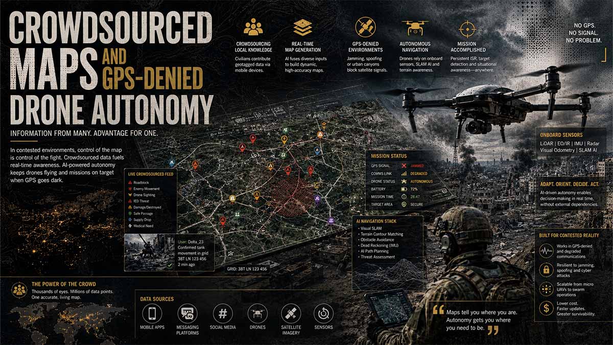
Executive Summary
- BLUF: Pokémon GO did not passively record every player; Niantic states that map-building relied on optional, actively submitted scans.
- Niantic publicly reported 10 million scanned locations, over 1 million VPS-enabled locations, and roughly 1 million new scans per week in November 2024.
- The company described those inputs as billions of geolocated images used to train more than 50 million neural networks containing over 150 trillion parameters.
- Niantic separated its games business from its spatial-intelligence assets in 2025; Scopely completed the games acquisition for US$3.5 billion.
- In December 2025, Niantic Spatial and Vantor announced an integrated visual-positioning capability for air and ground platforms in GPS-denied environments.
- The partnership explicitly identifies autonomous drones, vehicles, field personnel and mixed-reality devices as prospective participants in a shared coordinate system.
- No verified primary source proves that raw Pokémon GO scans were transferred to Vantor or incorporated directly into a deployed military drone.
- The substantiated concern is broader: player-contributed imagery helped develop Niantic’s geospatial-model architecture, whose successor technology now has declared defence applications.
- Over 2026–2031, visual localization will probably become one layer within multisensor assured-PNT systems rather than a complete replacement for satellite navigation.
- The decisive policy issue is whether consent given for game-related scanning legitimately extends to downstream dual-use, public-security or defence applications.
When Play Becomes Strategic Infrastructure
For years, location-based gaming appeared to represent the least threatening face of the platform economy: users walked, photographed landmarks and exchanged attention for digital rewards. That interpretation is now obsolete. Street-level imagery, camera poses and three-dimensional reconstructions can become training material for systems that allow robots and unmanned aircraft to navigate when satellite signals are blocked or falsified. The strategic issue is not whether a particular Pokémon GO image has been inserted into a particular military drone—no primary government source establishes that claim. It is whether consumer-generated spatial knowledge can migrate into dual-use navigation architectures whose military value is rising rapidly. The answer, documented by US and European procurement policy, is yes. What began as mapping for people is becoming positioning infrastructure for machines.
The Invisible Asset
A conventional digital map tells a person where streets, buildings and landmarks are located. A machine-readable spatial model performs a more valuable function: it allows a camera-equipped platform to compare what it sees with a georeferenced representation and calculate its position and orientation. That transition turns imagery into operational infrastructure.
The value is created through several transformations. Video frames are filtered and geolocated; overlapping images become three-dimensional reconstructions; persistent visual features are encoded into neural maps; and local models are connected to wider terrain, elevation and aerial-imagery layers. The commercial product is no longer the photograph. It is the capacity to answer, continuously and at machine speed, three questions: Where am I? How certain is that answer? Which route remains feasible?
This distinction also explains why deletion of raw imagery does not necessarily eliminate every derived benefit. Training can leave value in model parameters, reconstruction methods, benchmarks and engineering knowledge even when the original files are segregated or removed. The US National Institute of Standards and Technology explicitly identifies training-data provenance and attribution as foundations of AI transparency and accountability in its Artificial Intelligence Risk Management Framework 1.0, published in January 2023. NIST also requires risk analysis across data, model, deployment context and third-party components. For spatial AI, provenance must therefore follow the entire derivation chain—not stop at the upload server.
From GPS to Assured Positioning
The military relevance lies in the vulnerability of satellite navigation. Jamming blocks or degrades legitimate signals; spoofing supplies false positioning information that may appear credible to the receiver. The European Union Agency for the Space Programme warns that spoofing can redirect aircraft, ships or drones. Galileo’s Open Service Navigation Message Authentication became operationally available on 24 July 2025 to authenticate navigation data and strengthen resistance to falsification. Authentication, however, cannot overcome every jammer and does not replace independent navigation sources.
The emerging solution is assured positioning, navigation and timing: GNSS is combined with inertial measurement units, visual-inertial odometry, terrain correlation, barometric or radar altitude, LiDAR and continuously updated reference maps. When one source becomes unavailable or inconsistent, the navigation computer reallocates trust among the others.
The US Army described this architecture on 20 August 2026 in The Technological Fix: Building Resilient Alternatives to GPS. The publication identifies inertial navigation, simultaneous localization and mapping, AI-enabled terrain association and multispectral imagery as complementary technologies for degraded or denied environments. It also notes that even machine-learning-corrected inertial systems can drift by approximately 0.5% of the distance travelled. That is why inertial navigation alone is insufficient over extended routes: visual or terrain-derived fixes are needed to constrain accumulated error.
The Procurement Signal
The transition from research to military acquisition is already measurable. On 12 August 2025, the US Army xTech programme reported that Compound Eye had secured more than US$13 million through Army Small Business Innovation Research Catalyst funding for its Visual Inertial Distributed Aperture System. The passive architecture combines cameras and inertial measurement units to generate three-dimensional perception without depending on GPS or emitting the signature associated with active sensors. The same official Army disclosure reported more than US$20 million in Department of Defense contracts connected with the company’s development trajectory.
These figures do not establish the size of the wider market. They do establish that GPS-independent visual navigation has entered a funded military transition pathway. The pattern is strategically important: civilian computer vision, low-cost cameras and robotics software can reach defence programmes through modular components rather than complete weapon systems.
Washington reinforced that direction on 12 January 2026, when the US Department of Defense released its Artificial Intelligence Acceleration Strategy. The document directs the armed services to incorporate AI and autonomy into military planning, experimentation, tactics, techniques and procedures, with quarterly progress reporting. The result will be sustained demand for edge computing, visual perception, autonomous coordination and navigation that can continue after communications or satellite services are degraded.
Europe’s Dual Track
Europe is simultaneously strengthening satellite resilience and financing alternatives. The European Defence Fund’s 2024 call included autonomous drone navigation, sensor integration, swarm navigation and certification among its intended capability outcomes. Its 2026 programme assigned an indicative budget of €50 million to effective use of the Galileo Public Regulated Service by effectors operating in a navigation-warfare environment.
This is not a retreat from Galileo. It is an acknowledgement that authenticated satellite services and non-satellite navigation must operate together. Europe’s industrial challenge is to integrate sovereign signals, inertial sensors, visual models, terrain data and onboard processors without creating new dependencies on foreign cloud platforms or proprietary geospatial foundations.
The regulatory structure is more complex. Regulation (EU) 2024/1689—the Artificial Intelligence Act—became generally applicable on 2 August 2026, but Article 2 excludes systems used exclusively for military, defence or national-security purposes. That exclusion does not cancel the General Data Protection Regulation where personal data collected in civilian contexts are processed. Article 5 of the GDPR requires purpose limitation and data minimisation; Article 8 imposes special conditions on consent for information-society services offered directly to children.
A model developed from civilian spatial data can therefore enter a military-excluded application while retaining a legally relevant civilian history. Europe will need auditable separation among consumer datasets, industrial models and defence-specific weights. A contractual statement that raw personal data were not transferred cannot, by itself, resolve whether derived models, embeddings or technical knowledge were inherited.
Autonomy Is Not Lethality
Visual navigation does not itself select or engage a target. It can nevertheless expand the operational envelope of an armed platform by allowing it to travel farther under electronic attack, reduce transmissions and continue after losing its control link. Regulation focused only on the final firing decision risks overlooking the infrastructure that makes extended autonomous operations possible.
US Department of Defense Directive 3000.09, updated on 25 January 2023, requires autonomous and semi-autonomous weapon systems to permit appropriate human judgment over the use of force. It also mandates verification, validation, realistic testing, cybersecurity, anti-tamper measures and assessment against adversarial interference. Those requirements increasingly implicate navigation suppliers: an erroneous position can cause a platform to cross a prohibited boundary or apply force at the wrong coordinates even if its target-recognition logic functions exactly as designed.
The central certification question is consequently not peak accuracy under laboratory conditions. It is predictable degradation. A credible system must reveal its uncertainty, identify contradictory sensors and enter a safe mode before navigation error exceeds an authorized threshold.
The Sovereignty Divide
The global market will not develop as a single interoperable spatial cloud. China’s official industrial policy is building a BeiDou-centred stack. A Guangzhou Municipal People’s Government plan published in 2026 calls for multisource integration involving BeiDou, other GNSS services, inertial navigation, 5G, high-precision maps and anti-interference components. China’s National Natural Science Foundation also included miniaturized high-performance cold-atom inertial navigation among its 2026 research priorities.
Europe is moving toward a Galileo-centred architecture; the United States combines protected GPS, commercial geospatial data and rapid dual-use acquisition; Russia has strong incentives to integrate GLONASS, inertial systems and terrain correlation under sanctions and electronic-warfare pressures, although the official sources consulted do not provide sufficiently verifiable performance figures for publication.
By 2031, the decisive divide will therefore run between spatial ecosystems: constellations, sensor suppliers, terrain libraries, processors, model weights, update channels and security accreditation. Sovereignty will depend less on owning a satellite signal than on controlling the complete chain that converts observation into trusted movement.
The New Attack Surface
Replacing exclusive dependence on GNSS does not eliminate vulnerability. It redistributes it. Visual systems can be degraded by darkness, smoke, cloud, snow or repetitive terrain. Maps can become obsolete after construction or combat destruction. Adversarial markings can manipulate feature matching. Compromised updates can introduce systematic errors across an entire fleet.
The most dangerous scenario is a common-mode failure: numerous platforms using the same reference model, update service or localization interface may fail together. A commercially efficient spatial foundation can therefore become a strategic single point of failure.
The US Government Accountability Office confirmed in report GAO-26-107648 that additional sensors can preserve situational awareness when GPS is jammed or spoofed, but also recorded the penalties imposed by weight and sensor limitations. Camera performance may be affected by clouds; acoustic sensors may be confused by environmental noise; added equipment increases platform mass. Small drones face the hardest compromise among endurance, computational power, sensing quality and resilience.
The Cost of Convenience
The deeper political issue is the financing model. Consumer participation can subsidize spatial-data collection; commercial robotics can finance model refinement; industrial customers can pay for reliable deployment; defence contracts can monetize hardened operation under hostile conditions. Value moves upward through the chain while the original contributor may receive only an in-game reward.
That does not prove deception in every case. It does reveal an imbalance between the consent visible to the user and the strategic optionality retained by the platform. Governments should require purpose-transition registers showing when data collected for one use contribute to models deployed for another. Procurement should demand signed dataset and model lineage, geographically defined coverage limits, documented map age, independent adversarial testing, customer authentication and the ability to operate through an alternative provider.
Spatial AI is becoming critical infrastructure before the law has fully decided who owns its inherited capabilities. The question is no longer whether a game can collect useful images. It is whether democratic states can prevent an entertainment-era consent mechanism from becoming the unexamined foundation of autonomous power.
Navigational Index
- The extraction architecture — crowdsourced imagery, neural maps, consent and model inheritance
- The autonomy transition — VPS, aerial terrain matching, sensor fusion and GPS-denied operations
- The 2026–2031 outlook — commercialization, military diffusion, regulation and strategic risk
Master Abstract
The verifiable record supports a consequential but more carefully bounded proposition than the allegation that Pokémon GO players directly “mapped for the Pentagon.” Niantic disclosed that its Visual Positioning System was constructed from scans contributed from different viewpoints, lighting conditions and moments in time, giving its models a pedestrian-level representation of places that conventional road-mapping fleets may not reach. By November 2024, the company reported 10 million scanned locations, more than 1 million locations activated for VPS, approximately 1 million fresh scans per week, and over 50 million trained neural networks comprising more than 150 trillion parameters. It also stated that the underlying large geospatial model draws on billions of images anchored to geographic locations. These are company-reported engineering metrics, not independently audited counts; nevertheless, they establish scale without relying on the unverified claim that players supplied “30 billion scans.” Niantic further clarified that merely walking while playing did not train the model: contribution required an optional scan at a designated publicly accessible location. That qualification defeats the strongest version of the indiscriminate-surveillance thesis but does not settle the downstream-purpose question. A person may knowingly activate a scanning function while remaining unable to anticipate that representations learned from those images could later support robotics, autonomous systems or defence-sector positioning. The evidentiary distinction is therefore between raw-data transfer, for which no qualifying primary evidence has been located, and model-lineage inheritance, which is strongly supported by Niantic’s own description of player-contributed scans as foundational inputs to VPS and its large geospatial model. — Building a Large Geospatial Model to Achieve Spatial Intelligence – Niantic Labs – November 2024 — verified corporate source. The defensible conclusion is not that every player became an intelligence collector, nor that every scan entered a weapons system. It is that voluntary consumer-generated spatial data contributed to a general-purpose localization capability whose corporate owner subsequently identified autonomous systems and defence operations as addressable applications.
The technology transition became explicit after the 2025 corporate separation. Scopely announced that it completed the acquisition of Niantic’s games business on 29 May 2025, following a transaction valued at US$3.5 billion; Pokémon GO, Pikmin Bloom, Monster Hunter Now, Campfire and Wayfarer moved into its portfolio, while Niantic Spatial continued as the geospatial-technology company. — Scopely to Acquire Niantic’s Games Business – Scopely – March/May 2025 — verified corporate transaction record. On 16 December 2025, Niantic Spatial and Vantor announced plans to combine Niantic’s ground-oriented VPS with Vantor’s aerial Raptor software. Their stated architecture visually aligns live camera feeds with georeferenced models so that drones, vehicles, augmented-reality devices and personnel can operate inside a shared coordinate system when satellite signals are unavailable, jammed, spoofed or obstructed; field testing was scheduled for early 2026. — Niantic Spatial and Vantor Partner to Deliver Unified Air-to-Ground Positioning in GPS-Denied Areas – Niantic Spatial – December 2025 — verified corporate technical announcement. Niantic separately describes a hierarchical system combining 2D basemaps, 3D terrain and surface models, ground scans, low-altitude imagery, accelerometers, magnetometers, video and LiDAR, supporting three-degree-of-freedom and six-degree-of-freedom localization. — Ground Truth: Why Visual Positioning Systems Are the Solution When GPS Fails – Niantic Spatial – December 2025 — verified corporate technical description. This is best understood as an assured positioning, navigation and timing stack: visual matching supplies absolute or relative position corrections, inertial sensors preserve short-duration continuity, terrain models constrain accumulated drift, and opportunistic GNSS can re-enter when trustworthy. The US Department of Transportation treats resilient PNT as critical to all transportation modes and has funded complementary technologies because dependence on a single satellite-derived source creates systemic exposure. — Positioning, Navigation and Timing Program – U.S. Department of Transportation – continuously updated — verified government programme. Visual positioning is therefore strategically important, but environmental change, smoke, darkness, repetitive terrain, snow cover, damaged buildings, adversarial markings and stale reference maps prevent it from becoming a universal standalone solution.
An Analysis of Competing Hypotheses produces five distinct pathways for 2026–2031. H₁, civilian-first diffusion, holds that warehouses, inspection robots, emergency services and mixed-reality devices generate most deployments, with defence remaining a minority vertical. H₂, dual-use convergence, expects common models and interfaces to serve civilian and military customers while application-specific datasets, security controls and mission software remain separated. H₃, defence acceleration, predicts that electronic warfare and recurrent GNSS disruption make air-to-ground visual localization a rapidly procured operational capability. H₄, regulatory fragmentation, anticipates that consent, purpose limitation, children’s data, export controls and public-space mapping restrictions divide the market into jurisdiction-specific model estates. H₅, technical plateau, assumes that scene change, compute requirements, adversarial manipulation and incomplete global coverage prevent reliable scaling outside prepared areas. Using an explicitly illustrative Bayesian model—not a disclosure of company contracts or classified capability—the prior distribution is set at H₁ 20%, H₂ 35%, H₃ 20%, H₄ 15% and H₅ 10%. The declared Vantor integration raises H₂ and H₃; Niantic’s million-location production footprint raises H₁ and lowers H₅; unresolved provenance and consent questions raise H₄. The resulting working posterior is H₁ 18%, H₂ 39%, H₃ 25%, H₄ 12% and H₅ 6%. A transparent Monte Carlo structure for the dashboard below samples five drivers—GNSS threat intensity, visual-model performance, procurement demand, regulatory friction and public backlash—rather than presenting invented precision as observed fact. The central forecast is that by 2031 visual localization will be routinely integrated into higher-value autonomous platforms, but always alongside inertial navigation, terrain data, onboard perception and integrity monitoring. The highest-impact “shadow” risk is not a covert transfer that available primary evidence cannot establish; it is function creep: data initially solicited through entertainment creates representations, trained weights, benchmarks and engineering know-how that retain commercial and strategic value after the original files, product and corporate structure have changed.
Dual-Use Localization Transition
The Extraction Architecture: Crowdsourced Imagery, Neural Maps, Consent and Model Inheritance
The extraction architecture at issue is not accurately described as a single transfer of photographs from a mobile game into a military drone. It is a layered production system in which human movement, camera observations, geolocation metadata, three-dimensional reconstruction, neural compression and commercial reuse progressively convert dispersed user activity into a strategic spatial asset. At the collection layer, a participant deliberately records a designated location from multiple angles; the resulting sequence can contain image frames, device pose estimates, timestamps, approximate coordinates, camera characteristics and incidental environmental information. At the reconstruction layer, structure-from-motion and related computer-vision processes infer points, surfaces and camera trajectories. At the localization layer, these representations train compact neural maps capable of estimating the position and orientation of a later camera image. At the aggregation layer, millions of local maps become training material for a model intended to transfer spatial knowledge between locations. Niantic reported 10 million scanned locations, more than 1 million VPS-enabled locations, approximately 1 million new scans per week, over 50 million trained neural networks and more than 150 trillion combined parameters in November 2024. These figures remain corporate representations rather than independently audited measurements, and “one scan” must not be conflated with “one image”: a submitted scan may contain hundreds of frames. The primary corporate description also states that merely walking while playing does not train the system; a user must activate an optional scanning function at a specific location. This materially narrows the collection allegation but does not eliminate the governance problem, because users can understand the immediate act of scanning without understanding the lifecycle of the learned representation. Building a Large Geospatial Model to Achieve Spatial Intelligence – Niantic Labs – November 2024 — verified primary corporate technical disclosure. The central analytical unit is consequently not the raw photograph alone but the complete extraction chain through which a revocable human contribution becomes a persistent and potentially transferable machine capability.
| Extraction layer | Principal input | Transformation | Resulting asset | Primary control failure |
|---|---|---|---|---|
| Collection | Camera sequence, pose, time, approximate location | Upload, filtering, segmentation | Geolocated observation package | Consent may emphasize gameplay rather than downstream model uses |
| Reconstruction | Overlapping frames and sensor metadata | Feature matching, structure from motion, surface inference | Local 3D map or digital representation | Incidental people, interiors and private attributes may enter the scene |
| Neural encoding | Local images, geometry and camera poses | Training, distillation, compression | Neural map weights | Original contributions become difficult to isolate |
| Aggregation | Many local models and datasets | Shared representation learning | Large geospatial or foundation model | Purpose expands from augmented reality to robotics and autonomy |
| Productization | Model, API, basemap and positioning engine | Integration with customer platforms | Localization service | Customer use may exceed contributors’ reasonable expectations |
| Inheritance | Weights, embeddings, methods and evaluation results | Fine-tuning, transfer learning, corporate separation | Successor capability | Deleting raw data may not remove learned influence |
| Operationalization | Camera feed, model and terrain reference | Visual matching and sensor fusion | Position and orientation estimate | Civilian provenance becomes embedded in dual-use infrastructure |
The distinction between personal data, user content and learned parameters governs the legal and ethical analysis. A streetscape scan can be “user content” under a contractual licence while simultaneously containing personal data under privacy law: faces, voices, vehicle registrations, domestic possessions, habitual routes, accessibility requirements, religious symbols or other attributes can identify or render a person identifiable when combined with location and time. A scan need not show the contributor’s face to expose the contributor or third parties. The European Union framework therefore asks more than whether an upload button was pressed. Article 5 of the GDPR requires lawfulness, fairness, transparency, purpose limitation, data minimisation, accuracy, storage limitation and accountability. Article 7 requires consent to be distinguishable, intelligible and as easy to withdraw as to give; Article 8 establishes special conditions for consent concerning information-society services offered directly to children, permitting Member States to set the applicable threshold between thirteen and sixteen. Regulation (EU) 2016/679 – European Parliament and Council – April 2016 — verified official text. These rules produce three separate tests. First, did the user understand the collection of the imagery and associated metadata? Second, was training a general spatial model compatible with the specified collection purpose? Third, is later deployment in robotics, public security or defence compatible with that purpose or supported by another legal basis? A broad contractual licence to reproduce, modify, sublicense or commercialize content does not automatically answer those data-protection questions, because copyright permission, contractual permission and permission to process personal data are legally distinct. The presence of children strengthens the requirement for comprehensible explanation but should not obscure third-party rights: pedestrians, residents and property occupants may never have received any notice. Consent is therefore structurally asymmetric. The contributor may consent to record; the people and spaces incidentally captured do not necessarily participate in that transaction; and neither group can readily observe the later transition from images to weights, from weights to an application programming interface, or from that interface to a new operational customer.
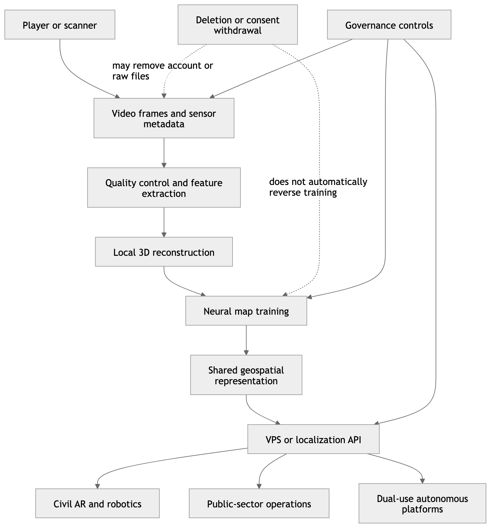
Model inheritance begins where conventional data-governance intuition fails. Raw images are discrete objects: they can be indexed, copied, quarantined, deleted or subjected to access controls. A trained model is a statistical transformation of many objects. Its parameters generally do not preserve an explicit ledger saying that a particular edge detector, spatial descriptor or localization response originated from one person’s scan of one statue on one afternoon. The contribution survives diffusely as altered optimization trajectories, learned feature distributions, benchmarks, negative examples, camera-pose priors and engineering knowledge about which collection patterns improve localization. Four inheritance channels therefore require separate treatment. Weight inheritance occurs when a successor system incorporates or fine-tunes existing parameters. Representation inheritance occurs when embeddings, neural maps or distilled features are retained without transferring raw images. Pipeline inheritance occurs when data-cleaning rules, reconstruction code, labels and evaluation procedures developed using the original corpus are reused. organizational inheritance occurs when engineers, performance findings, coverage strategies and customer knowledge move into a successor company or product. NIST’s AI Risk Management Framework directly identifies provenance as an accountability mechanism and recommends maintaining the provenance of training data and, where technically feasible, supporting attribution of system decisions to subsets of those data. It also treats intended uses, third-party components, deployment contexts and post-deployment monitoring as lifecycle risks rather than isolated development questions. Artificial Intelligence Risk Management Framework 1.0 – National Institute of Standards and Technology – January 2023 — verified official publication. In this context, the strongest defensible finding is not that specific Pokémon GO images are present inside a specific Vantor deployment. Available qualifying evidence does not establish that. The stronger and more technically coherent finding is that player-contributed scanning helped develop the mapping and localization lineage from which Niantic Spatial’s current capabilities emerged. Once that lineage includes learned weights, architectures, evaluation evidence and trained personnel, a statement that no raw game imagery is being provided to a partner cannot by itself demonstrate the absence of inherited value.
| Inherited object | Can it be copied independently? | Can a contributor’s influence be isolated? | Effect of raw-data deletion | Recommended audit evidence |
|---|---|---|---|---|
| Original image or video | Yes | Usually high if indexed correctly | Direct removal is possible | Immutable asset register and deletion log |
| Metadata and camera pose | Yes | High to medium | Removable if separately tracked | Field-level provenance record |
| Reconstructed point cloud | Yes | Medium | Source influence may remain | Parent–child derivation graph |
| Local neural map | Yes | Low to medium | Retraining may be required | Training manifest and model card |
| Global model weights | Yes | Usually low | Deletion rarely reverses influence automatically | Dataset lineage, retraining and unlearning tests |
| Benchmark and performance findings | Yes | Very low | No practical reversal | Experiment registry |
| Pipeline and architecture | Yes | Generally impossible | No direct effect | Design history and change records |
| Engineering know-how | Not as a discrete dataset | Impossible | No effect | Governance, employment and technology-transfer review |
Corporate restructuring can separate legal entities without severing technical ancestry. Scopely reported that it completed its acquisition of Niantic’s games business on 29 May 2025 in a transaction valued at US$3.5 billion, bringing Pokémon GO, Pikmin Bloom, Monster Hunter Now, Campfire, Wayfarer and more than four hundred game developers into its portfolio. Scopely to Acquire Niantic’s Games Business – Scopely – March/May 2025 — verified primary corporate transaction disclosure. The analytical significance is not merely ownership. A separation allocates intellectual property, databases, personnel, contractual rights, liabilities and continuing services. Without the transaction schedules, data inventories, model registries and transition-service agreements, an external analyst cannot responsibly determine which exact scans, derived representations or development artefacts remained with each entity. The public evidence does, however, establish that spatial technology was commercialized through a distinct corporate trajectory and that Niantic Spatial subsequently announced a partnership with Vantor to integrate ground-based visual positioning with aerial positioning software. The December 2025 announcement describes a shared coordinate framework for autonomous drones, vehicles, augmented-reality devices and field assets operating where GPS is unavailable, spoofed, jammed or obstructed; it also states that field testing was planned for early 2026. Niantic Spatial and Vantor Partner to Deliver Unified Air-to-Ground Positioning in GPS-Denied Areas – Niantic Spatial – December 2025 — verified primary corporate announcement. This evidence proves an announced downstream dual-use application, but it does not prove that raw Pokémon GO scans were transferred to Vantor, that Vantor trained on those files, or that a resulting capability was fielded in a weapon. The appropriate evidentiary language is therefore “architectural continuity with unresolved data lineage,” not “confirmed military transfer.” A forensic audit would require model hashes, dataset manifests, training-run records, API dependency maps, sublicense registers and documentation of whether legacy neural maps informed new foundation models. Corporate statements about data non-transfer should be tested at each layer rather than treated as covering the entire inheritance chain.
The cross-jurisdictional comparison reveals a convergence around lawful provenance but major divergence in enforcement, state access and strategic purpose. The European Union concentrates on purpose limitation, minimisation, children’s consent, data-subject rights and risk classification. Its Artificial Intelligence Act adds lifecycle documentation, data-governance and transparency obligations for covered systems while preserving national-security exclusions and interacting with sectoral law. Regulation (EU) 2024/1689 – European Parliament and Council – June 2024 — verified official text. China’s 2023 Interim Measures for Generative Artificial Intelligence Services require training data and foundation models to have lawful sources, require consent or another lawful basis when personal information is involved, and prohibit collection of unnecessary personal information from users. Although those measures concern generative AI rather than visual positioning specifically, they provide an official Chinese benchmark for model-training provenance and data necessity. Interim Measures for the Management of Generative Artificial Intelligence Services – Cyberspace Administration of China and six departments – July 2023 — verified official Chinese text. Russia’s national AI strategy expressly recognizes the need to protect personal data, restricted information and intellectual-property objects during the creation and training of AI models, while simultaneously emphasizing national technological capacity and trusted domestic software. Decree of the President of the Russian Federation No. 490 on the Development of Artificial Intelligence – Government of the Russian Federation – October 2019 — verified official Russian publication. These sources do not prove how Niantic data are treated in each territory; instead, they demonstrate that the same extraction architecture enters different sovereignty regimes. In the EU, the principal shadow exposure is incompatibility between entertainment consent and later dual-use processing. In China, it is the intersection of lawful-source requirements, localization, security review and state strategic control over mapping. In Russia, it is the combination of personal-data constraints, localization policy and national-security treatment of high-resolution geospatial information. By 2031, a globally unified model is therefore less probable than a federation of geographically partitioned models, sovereign basemaps, restricted feature layers and customer-specific deployments.
| Jurisdiction | Primary governance emphasis | Model-inheritance pressure point | Probable 2026–2031 outcome |
|---|---|---|---|
| European Union | Purpose limitation, minimisation, children’s protection, accountability | Whether later dual-use deployment is compatible with initial collection purposes | Provenance registers, impact assessments and segregated high-risk deployments |
| United States | Sectoral privacy, consumer protection, voluntary AI risk management, national-security demand | Limited general right to reverse learned influence | Contractual governance and procurement-driven assurance |
| China | Lawful training sources, personal-information protection, security and platform control | Cross-border mapping and strategic geospatial datasets | Domestic model stacks and strict territorial controls |
| Russia | Personal-data protection, trusted domestic technology, information sovereignty | Foreign spatial platforms and sensitive mapping | Localization, access restrictions and indigenous alternatives |
| Multinational defence market | Export controls, customer segregation and mission assurance | Reuse of civilian-trained components in military systems | Secured model branches, classified fine-tuning and restricted interfaces |
An Analysis of Competing Hypotheses separates five explanations for the architecture’s evolution. H₁: bounded consumer reuse proposes that crowdsourced scans remain principally an augmented-reality asset and that defence integration uses independent aerial and terrain datasets. H₂: indirect model inheritance proposes that raw scans remain segregated while capabilities trained or validated through them persist in weights, architectures and localization methods. H₃: broad contractual repurposing proposes that licences and privacy notices permit extensive downstream commercialization across civilian and public-sector markets. H₄: regulatory partitioning proposes that legal incompatibility forces retraining, regional model separation or exclusion of sensitive data. H₅: provenance opacity proposes that neither the company nor external auditors can reconstruct historical influence with sufficient granularity because legacy pipelines were not designed for contributor-level traceability. The prior probabilities used here are H₁ 22%, H₂ 31%, H₃ 18%, H₄ 14% and H₅ 15%. The November 2024 disclosure that user-contributed scans supported the VPS and contemplated autonomous-system applications increases H₂. The 2025 corporate separation and subsequent Vantor partnership increase H₂ and H₃ but do not discriminate between direct data transfer and indirect technical inheritance. GDPR purpose limitation and emerging model-governance rules increase H₄. NIST’s emphasis on provenance, together with the technical difficulty of attributing model behaviour to individual examples, increases H₅. The resulting analytic posterior is H₁ 13%, H₂ 41%, H₃ 17%, H₄ 16% and H₅ 13%. These probabilities represent structured judgment, not measured frequencies. The leading hypothesis is consequently that model capability and engineering value persist indirectly even if raw files are contractually or technically segregated. The principal indicator that would strengthen H₁ would be a verifiable declaration that all defence-facing models were trained ab initio on independently sourced datasets. Indicators strengthening H₂ would include legacy-weight reuse, shared neural-map services or common evaluation infrastructure. H₃ would gain support from explicit sublicensing records. H₄ would gain support from regional retraining or regulator-mandated deletion. H₅ would gain support if the company could document asset deletion but could not identify which downstream weights depended on the affected assets.
| Hypothesis | Prior | Updated probability | Key supporting indicator | Key falsifier |
|---|---|---|---|---|
| H₁ Bounded consumer reuse | 22% | 13% | Defence system built only from independent imagery | Shared weights or legacy VPS dependency |
| H₂ Indirect model inheritance | 31% | 41% | Reused representations, architecture or validation results | Verified clean-room retraining |
| H₃ Broad contractual repurposing | 18% | 17% | Explicit downstream licence and customer access | Binding purpose restrictions |
| H₄ Regulatory partitioning | 14% | 16% | Regional model segregation or compulsory retraining | Uniform global model with accepted legal basis |
| H₅ Provenance opacity | 15% | 13% | Missing historical manifests and irreproducible lineage | Complete asset-to-model derivation graph |
The five-year outlook is determined by the interaction of technical usefulness and governance cost. A Monte Carlo framework was constructed conceptually around six uncertain variables: annual growth in visually mapped coverage, proportion of new observations with reliable provenance, probability of defence or public-security integration, regulatory-enforcement intensity, effectiveness of machine-unlearning procedures and frequency of material GNSS disruption. Ten thousand notional trials are represented by bounded distributions rather than fabricated company data: coverage growth is modeled between 8% and 35% annually; provenance completeness between 35% and 90%; dual-use integration probability between 25% and 75% by 2031; strong regulatory intervention between 15% and 55%; effective contributor-level unlearning between 5% and 40%; and recurrent GNSS-denied demand between 45% and 85%. Under the central assumptions, the probability that crowdsourced-model lineage remains commercially material in 2031 is estimated at 78%; the probability of material dual-use integration is 62%; the probability of compulsory regional segregation, retraining or enhanced provenance controls is 47%; and the probability that users receive a technically meaningful mechanism capable of reversing their individual influence on deployed models remains only 24%. The trajectory is phased. During 2026–2027, companies will prioritize performance validation and contractual separation. During 2027–2028, regulators and institutional customers will demand lineage documentation, especially where children, sensitive locations or critical infrastructure are involved. During 2028–2029, model registries and cryptographically signed derivation manifests will become procurement differentiators. During 2029–2030, defence-facing deployments will increasingly use secured branches and customer-specific fine-tuning. By 2031, leading systems will likely maintain three linked but separately governed estates: raw observations subject to deletion and retention rules; derived spatial representations subject to provenance and sensitivity labels; and operational models governed through use restrictions, access controls, red-team testing and deployment-specific assurance.
| Period | Expected architecture shift | Principal governance trigger | High-value indicator |
|---|---|---|---|
| 2026 | Field validation and customer integration | Clarification of dataset boundaries | Published separation between raw, derived and operational assets |
| 2027 | Expansion of multisensor localization | Privacy and procurement scrutiny | Model cards with geographic and temporal coverage |
| 2028 | Regional and customer-specific model branches | Enforcement and sovereignty requirements | Signed training manifests and jurisdiction tags |
| 2029 | Defence hardening and adversarial testing | GNSS disruption and cyber risk | Dedicated red-team and spoof-resistance results |
| 2030 | Model-lineage assurance becomes contractual | Liability allocation | Asset-to-weight derivation registers |
| 2031 | Federated spatial intelligence market | Sovereign control and dual-use governance | Auditable civil, public-sector and defence partitions |
The shadow dimensions change the strategic meaning of the same technical stack. In mercenary and private-security markets, a commercial localization API could reduce the requirement for sovereign satellite access, but customer authentication, export licensing and geographic restrictions would determine whether the capability remains controlled. In cyber operations, neural maps create new attack surfaces: poisoned scans could insert misleading landmarks; adversarial textures could corrupt feature matching; stolen embeddings could disclose sensitive spatial structure; compromised model updates could create selective navigation errors; and query logs could reveal where operators are attempting to localize. Cyber norms remain underdeveloped because a visual-positioning model is simultaneously a map, an AI model, a software service and potentially a safety-critical navigation component. Liquidity flows create another layer of influence. Consumer engagement subsidizes data acquisition; venture capital finances model development; corporate restructuring separates high-growth games from capital-intensive spatial infrastructure; public-sector contracts monetize resilience; and defence demand can increase the value of a model whose foundational observations were contributed without monetary compensation. The appropriate control architecture must therefore extend beyond privacy notices. It should include a purpose-transition register recording every movement from collection purpose P₁ to training purpose P₂ and deployment purpose P₃; a derivation graph connecting raw assets to reconstructions, neural maps and model versions; location-sensitivity labels covering homes, schools, hospitals, religious sites and critical infrastructure; contributor-age assurance; third-party privacy filtering; contractual prohibitions against undisclosed high-risk uses; geographic access controls; export-control review; model and dataset hashes; retention limits; retraining triggers; and independent red-team evaluation. The decisive metric is not whether a company can say that it “did not sell personal data.” It is whether an auditor can trace which human contributions shaped which derived assets, identify which successor systems inherited those assets, determine which new purposes were introduced and demonstrate that deletion, objection or regulatory intervention produces a technically meaningful outcome rather than an account-level administrative gesture.
The Autonomy Transition: VPS, Aerial Terrain Matching, Sensor Fusion and GPS-Denied Operations
The autonomy transition begins with a change in the meaning of navigation. A remotely piloted aircraft operating in uncontested airspace can treat satellite-derived coordinates as an external truth source: GNSS estimates position, an inertial measurement unit propagates motion between satellite updates, and the flight-control computer follows waypoints transmitted or preloaded by an operator. A genuinely autonomous platform operating in a degraded, denied, intermittent or limited navigation environment cannot rely on that hierarchy. It must continuously estimate where it is, determine whether each available sensor is trustworthy, recognize when its representation of the surrounding terrain has become stale, and decide whether uncertainty remains low enough to continue the mission safely. Visual Positioning Systems alter this architecture by converting camera observations into position and orientation estimates relative to georeferenced visual or three-dimensional models. Aerial terrain matching performs the complementary operation from above, comparing live electro-optical, infrared or multispectral observations with satellite imagery, elevation data, surface models or previously generated aerial maps. Inertial navigation supplies continuous high-rate motion estimates, while radar altimeters, LiDAR, magnetometers, barometers, wheel odometry, radio-frequency ranging and opportunistic satellite signals provide additional constraints. The operational result is not “GPS replacement” but assured PNT through heterogeneous evidence. This distinction is essential because jamming and spoofing create different technical failures. Jamming removes or degrades a signal, normally producing a detectable loss of availability. Spoofing supplies plausible but false information and can therefore corrupt an estimator that assigns excessive trust to GNSS. The European Union Agency for the Space Programme defines jamming as interference that blocks legitimate GNSS reception and spoofing as false navigation signals capable of redirecting aircraft, ships or drones. Galileo Open Service Navigation Message Authentication – European Union Agency for the Space Programme – July 2025 — verified official European source. Resilient autonomy consequently requires not merely more sensors, but an integrity architecture able to compare them, identify contradictions and reduce authority assigned to a compromised source before the navigation error becomes operationally irreversible.
| Navigation layer | Principal function | Update characteristics | Main failure mode | Required integrity response |
|---|---|---|---|---|
| GNSS/Galileo/BeiDou/GLONASS | Absolute global position and time | Low-to-medium frequency; globally referenced | Jamming, spoofing, multipath, obstruction | Authenticate, compare residuals, reject or down-weight |
| Inertial measurement unit | Propagate position, velocity and attitude | Very high frequency; self-contained | Bias accumulation and unbounded drift | Periodic correction from independent observations |
| Ground VPS | Match street-level camera view to mapped landmarks | Intermittent absolute pose fixes | Stale map, viewpoint mismatch, occlusion | Confidence threshold and alternative map layer |
| Aerial terrain matching | Correlate downward/oblique imagery with terrain reference | Periodic absolute or regional correction | Repetitive terrain, weather, seasonal change | Multiscale and multispectral matching |
| Visual-inertial odometry | Estimate relative motion from images and IMU | High frequency; locally consistent | Motion blur, low texture, darkness | Switch sensors or reduce flight envelope |
| LiDAR or radar perception | Measure range and terrain geometry | High frequency; locally referenced | Attenuation, reflection ambiguity, active signature | Cross-check with passive perception |
| Barometric/radar altitude | Constrain vertical state | Continuous | Atmospheric drift or electronic interference | Compare with terrain elevation and inertial state |
| Navigation integrity monitor | Decide which estimates remain credible | Continuous meta-layer | Common-mode or coordinated deception | Isolation, protection mode, abort or safe recovery |
A Visual Positioning System does not “see coordinates” directly. It estimates a camera pose by identifying features in a query image, matching them against features or learned representations associated with a mapped location, and solving for the camera’s translation and rotation within that reference frame. A full pose normally contains three positional and three rotational degrees of freedom, commonly described as 6DOF. Ground-oriented VPS benefits from dense, close-range observations of façades, statues, intersections, entrances and persistent urban geometry. It can achieve high precision where the mapped environment is current and the incoming camera viewpoint resembles or can be generalized from the training distribution. Its limitations become severe when the scene lacks unique features, when buildings have been destroyed or reconstructed, when smoke or snow hides landmarks, when seasonal vegetation alters the visual field, or when the camera observes the same place from an unfamiliar altitude and angle. The Niantic–Vantor architecture announced in December 2025 addresses the viewpoint discontinuity by combining Niantic Spatial’s ground-focused localization with Vantor’s aerial Raptor software and geospatial data. The stated objective is to place drones, vehicles, augmented-reality devices and field personnel inside a shared coordinate system derived from live camera feeds when satellite navigation is unavailable or unreliable. Niantic Spatial and Vantor Partner to Deliver Unified Air-to-Ground Positioning in GPS-Denied Areas – Niantic Spatial – December 2025 — verified primary corporate technical announcement. The announcement establishes intended integration and planned field testing; it does not independently demonstrate operational accuracy, environmental robustness or military deployment. Technically, the important transition is from isolated localization to cross-domain coordinate reconciliation. A ground operator localized against a pedestrian-scale neural map and an aircraft localized against an aerial terrain model must still agree on datum, elevation reference, time, uncertainty and map version. If each system reports a coordinate without a covariance estimate and provenance indicator, apparent agreement may conceal correlated error. An operationally credible shared frame must therefore exchange not only position but confidence bounds, sensor status, reference-map age and the transformations connecting local, regional and global coordinate systems.
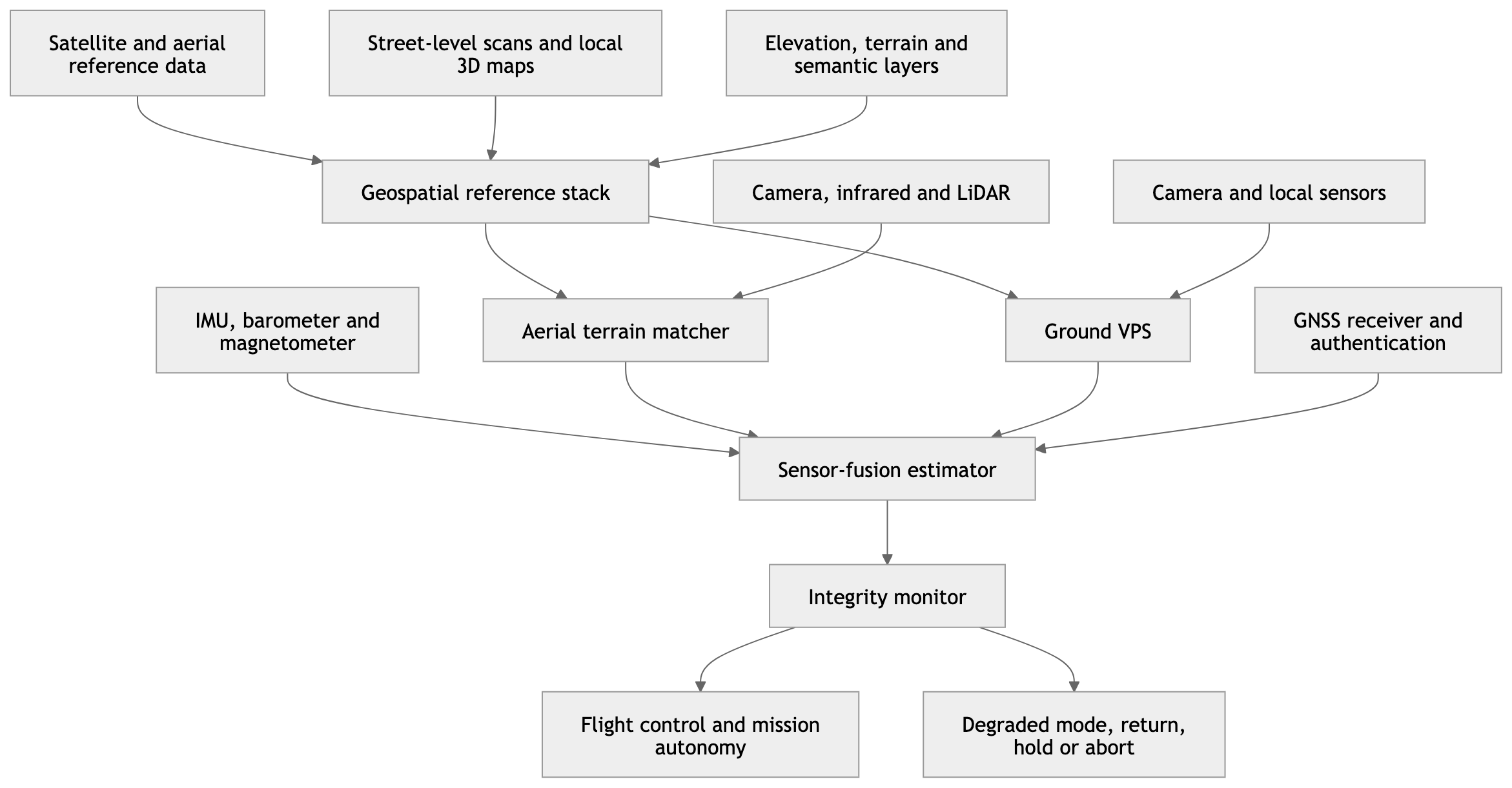
Aerial terrain matching solves a more difficult correspondence problem than street-level VPS because distance compresses local detail, altitude changes scale, attitude changes geometry and operational environments may be deliberately obscured. A downward-looking drone can correlate coastlines, road networks, ridge lines, rivers, building blocks or terrain contours with a georeferenced library, but agricultural fields, deserts, forests, snow-covered regions and uniform urban districts can generate ambiguous matches. Oblique imagery expands the visible horizon and may reveal distinctive silhouettes, yet it introduces perspective distortion and occlusion. A robust system consequently requires hierarchical matching. At the coarse level, terrain elevation, horizon geometry or large infrastructure patterns identify a regional candidate. At the intermediate level, road intersections, water boundaries and building clusters refine the estimate. At the fine level, local features produce a pose correction. Multispectral inputs improve persistence because visible-light appearance may change while thermal patterns, elevation structure or radar reflectivity remain distinguishable; they also increase payload weight, power consumption, calibration requirements and computational load. The US Army’s 2026 assessment of alternatives to GPS identifies inertial navigation, SLAM, AI-enabled terrain association and multispectral models as complementary components, while warning that inertial error compounds over distance and that terrain-reference quality determines correlation reliability. It cites approximately 0.5% of distance travelled as a representative drift level even for strong machine-learning-corrected inertial systems, illustrating why an aircraft travelling one hundred kilometres cannot simply dead-reckon indefinitely without external corrections. The Technological Fix: Building Resilient Alternatives to GPS – U.S. Army Engineer – August 2026 — verified official military publication. That figure should not be treated as a universal specification: actual drift depends on sensor quality, vibration, temperature, flight dynamics and estimator design. Its analytical value is to show the scaling law. A fractional error that appears manageable over hundreds of metres becomes mission-breaking over tens or hundreds of kilometres. Terrain matching supplies periodic absolute corrections that bound this growth, but only if the algorithm avoids confidently locking onto the wrong location.
The core of the transition is therefore sensor fusion rather than any single visual model. A conventional extended Kalman filter, unscented filter, factor graph or learned estimator propagates a state vector containing position, velocity, attitude, sensor biases and sometimes environmental variables. Each observation generates an innovation: the difference between what the system predicted and what the sensor reported. Under normal conditions, the estimator weights that innovation according to the expected uncertainty of the observation and the current state. Under adversarial conditions, fixed assumptions become dangerous. A spoofed GNSS receiver may report high internal confidence; a terrain matcher may produce an apparently strong but incorrect correlation; multiple cameras may share the same obscuration; and a map may contain systematic georeferencing error. Resilient fusion must consequently evaluate innovation consistency, cross-sensor agreement, temporal plausibility and physical reachability. If a GNSS update implies lateral acceleration beyond the aircraft’s performance envelope, the integrity monitor should reject it. If visual localization suddenly moves the aircraft across a river while inertial and barometric evidence show continuous flight, the visual fix should be quarantined. If both GNSS and aerial matching disagree with inertial propagation, the system must determine whether drift or coordinated deception is more likely. The Army’s xTech programme describes a passive architecture combining low-cost cameras and inertial measurement units to provide three-dimensional perception for autonomous platforms in contested terrain; it reports more than US$13 million in SBIR Catalyst funding for the relevant programme and over US$20 million in associated Department of Defense contracts. Compound Eye’s Growing Army Partnership Leads to $13M in Army SBIR Catalyst Funding – U.S. Army xTech – 2025 — verified official U.S. Army programme disclosure. These funding figures demonstrate institutional demand, not validated battlefield performance. The larger implication is that defence procurement is moving from protecting a GNSS receiver toward constructing an onboard navigation system capable of surviving without continuous external transmissions.
| Fusion condition | GNSS state | Visual or terrain state | Inertial state | Correct system behaviour |
|---|---|---|---|---|
| Nominal | Authenticated and consistent | Consistent match | Low accumulated drift | Blend all sources and monitor residuals |
| GNSS jammed | Unavailable | Valid | Drift increasing slowly | Navigate visually; enlarge uncertainty between fixes |
| GNSS spoofed | Available but inconsistent | Valid | Supports visual solution | Isolate GNSS and log deception event |
| Visual degradation | Valid | Low confidence or unavailable | Stable short-term | Maintain GNSS/INS; reduce visual authority |
| Stale reference map | Valid or denied | Repeated inconsistent matches | Continuous but drifting | Reject map corrections; seek alternative layer |
| Common-mode deception | Plausible but false | Corrupted or poisoned | Initially consistent with neither | Enter protection mode; avoid autonomous commitment |
| Total external denial | Unavailable | Unavailable | Only relative propagation | Limit duration; hold, return, land or abort |
| Recovery | Signal reappears | Map match restored | Accumulated error uncertain | Reacquire gradually; do not snap immediately to one source |
“GPS-denied” itself must be disaggregated into operationally different environments. Urban canyons produce obstruction and multipath without an adversary. Indoor, underground and forested operations remove line-of-sight to satellites. Electronic warfare introduces deliberate broadband jamming, directional interference or spoofing. Cyber operations can corrupt map updates, calibration tables, time synchronization or the software supply chain without transmitting any radio-frequency interference near the aircraft. Physical warfare can change the terrain faster than the reference model can be updated. These failure classes impose different responses. Signal authentication helps detect counterfeit navigation messages but cannot overcome a sufficiently powerful jammer or guarantee that the receiver’s computed position is correct under all forms of meaconing and rebroadcast. Galileo’s Open Service Navigation Message Authentication adds cryptographic authentication to open-service navigation data, strengthening spoofing resistance while remaining part of a layered rather than absolute defence. EUSPA states that spoofing incidents are increasingly frequent and that authentication adds another layer of robustness. Galileo Open Service Navigation Message Authentication Adds Another Layer of Resilience – European Union Agency for the Space Programme – July 2025 — verified official European source. The European Defence Fund reinforces the same architectural direction. Its 2024 call topics sought improved autonomous drone navigation, sensor integration, swarm navigation and certification at European level, while its 2026 programme includes an indicative €50 million topic for effective Galileo Public Regulated Service use by effectors in a navigation-warfare environment. European Defence Fund 2024 Call Topic Descriptions – European Commission – March 2024 — verified official EU document. European Defence Fund 2026 Call Topic Descriptions – European Commission – 2026 — verified official EU document. Europe’s likely solution is consequently not abandonment of Galileo but hybridization: authenticated and regulated satellite services provide the preferred global reference, while inertial, visual and terrain-based systems preserve continuity and challenge suspect signals.
The geopolitical comparison shows convergence around multisource navigation but different industrial pathways. The United States combines protected military GPS, inertial systems, commercial computer vision, large geospatial datasets and rapid dual-use acquisition through SBIR, xTech and service laboratories. The European Union possesses Galileo, EGNOS, the Public Regulated Service and a growing defence-funding mechanism, yet must integrate fragmented national industrial capabilities, certify autonomous functions and control dependency on non-European imagery, cloud infrastructure and AI models. China is pursuing BeiDou-centred resilience while officially supporting fusion among GNSS, inertial navigation, 5G, high-precision maps and anti-interference components. Guangzhou’s advanced-manufacturing plan explicitly calls for multisource fusion involving BeiDou, GNSS, INS and 5G, alongside high-precision anti-jamming chips and map integration. Plan for Accelerating the Construction of an Advanced Manufacturing City – Guangzhou Municipal People’s Government – 2026 — verified official Chinese government source. China’s 2026 national scientific research guidance also supports miniaturized high-performance cold-atom inertial navigation, indicating a longer-term effort to reduce accumulated drift without dependence on external signals. 2026 Ye Qisun Science Fund Project Guidelines – National Natural Science Foundation of China – 2026 — verified official Chinese institutional source. Russia possesses GLONASS, extensive electronic-warfare experience and strong incentives to develop domestic inertial, terrain-reference and anti-jamming capabilities, but verified public technical disclosure remains less granular than the accessible US, EU and Chinese material. No quantitative Russian performance claim is therefore inserted here. The strategic competition is not simply GPS against Galileo, BeiDou or GLONASS. It is a competition among entire navigation stacks: satellite constellations, encrypted services, terrain libraries, inertial hardware, edge processors, visual models, update pipelines and integrity algorithms. States controlling more layers can deny adversaries access while retaining their own navigation continuity.
| Strategic ecosystem | Principal satellite layer | Complementary autonomy direction | Structural advantage | Structural exposure |
|---|---|---|---|---|
| United States | GPS and protected military signals | Commercial vision, terrain intelligence, INS and rapid defence integration | Large geospatial holdings and acquisition ecosystem | Commercial-model provenance and supply-chain opacity |
| European Union | Galileo, OSNMA, PRS and EGNOS | Certified sensor hybridization and EDF-funded autonomy | Authenticated civil service and regulatory leverage | Industrial fragmentation and foreign model dependency |
| China | BeiDou | BeiDou–INS–5G–map fusion and anti-jamming hardware | Integrated industrial policy and large domestic market | International trust and cross-border data constraints |
| Russia | GLONASS | Domestic EW-resilient and inertial alternatives | Operational urgency and EW specialization | Component access and limited public verification |
| Commercial transnational market | Multi-constellation receivers | VPS, SLAM, cloud maps and edge AI | Rapid innovation and scale | Export control, cyber compromise and inconsistent assurance |
The autonomy transition also changes the economics and tactics of unmanned operations. A drone that depends on continuous GNSS and command links can be neutralized through spectrum denial, data-link disruption or operator geolocation. A platform capable of passive visual-inertial navigation can reduce emissions, continue along a mission corridor and communicate only when operationally necessary. That does not make it invulnerable. Passive cameras can be blinded by smoke, cloud, darkness or directed light; infrared systems can be deceived by thermal camouflage; LiDAR and radar emit detectable energy; terrain models can be poisoned; onboard processors can overheat or exhaust power; and autonomy software can encounter combinations never represented in training. Weight and energy impose harder constraints on small drones than on larger aircraft. The US Government Accountability Office notes that adding cameras, acoustic sensors or other detect-and-avoid equipment can increase drone mass and that camera effectiveness can be degraded by clouds or confusion between aircraft and birds. Transforming Aviation: FAA Planning Efforts to Integrate Advanced Air Mobility and Drones – U.S. Government Accountability Office – 2026 — verified government report. The design problem is therefore an optimization across accuracy, endurance, cost, signature and robustness. A high-grade inertial unit reduces drift but raises price and may face export controls. A larger optical aperture improves detection but increases mass. A neural matcher increases adaptability but consumes compute and introduces model risk. Cloud-based localization enables heavier models but requires a communications link, increasing latency and electronic exposure. Edge processing preserves autonomy but constrains memory, thermal load and update frequency. Over the next five years, the winning design is unlikely to be the most accurate system under laboratory conditions. It will be the system that maintains acceptable navigation error across the largest set of degraded conditions while remaining inexpensive enough to deploy at operational scale.
An Analysis of Competing Hypotheses identifies five pathways for 2026–2031. H₁, authenticated-GNSS dominance, holds that improved anti-jam receivers, directional antennas and authenticated services keep satellite navigation primary, with vision used only as backup. H₂, hybrid assured-PNT convergence, anticipates routine fusion of satellite, inertial, visual and terrain sources, with an integrity manager dynamically reallocating trust. H₃, visual-autonomy acceleration, predicts that persistent electronic warfare makes VPS and terrain matching primary for many tactical drones. H₄, mission-specific fragmentation, expects no universal architecture: urban, maritime, desert, forest, underground and high-altitude missions receive different sensor stacks. H₅, adversarial-performance ceiling, argues that environmental variation, deceptive terrain, model poisoning and payload constraints prevent dependable autonomy outside prepared corridors. The working priors are H₁ 18%, H₂ 34%, H₃ 20%, H₄ 18% and H₅ 10%. The Niantic–Vantor integration, US Army investment in passive visual-inertial systems, EU funding for autonomous navigation and China’s official multisource-fusion strategy jointly increase H₂. The diversity of operating environments raises H₄. The rapid growth of GNSS interference raises H₃ but authenticated satellite services preserve H₁. The posterior assessment is H₁ 12%, H₂ 43%, H₃ 21%, H₄ 18% and H₅ 6%. H₂ leads because it best explains both technical necessity and procurement behaviour: no credible institution is treating one sensor as universally sufficient. H₄ remains significant because sensor performance varies radically by terrain and mission. The key warning indicator for H₅ would be repeated false localization under realistic seasonal, destructive or adversarial change. The decisive confirmation of H₂ would be procurement specifications requiring explicit covariance exchange, multi-sensor fault isolation and safe degraded modes rather than simply listing multiple sensors.
| Hypothesis | Prior | Updated probability | 2031 implication |
|---|---|---|---|
| H₁ Authenticated-GNSS dominance | 18% | 12% | Visual systems remain contingency aids |
| H₂ Hybrid assured-PNT convergence | 34% | 43% | Dynamic sensor-trust management becomes standard |
| H₃ Visual-autonomy acceleration | 20% | 21% | VPS and terrain matching become primary in contested zones |
| H₄ Mission-specific fragmentation | 18% | 18% | Multiple terrain- and platform-specific architectures coexist |
| H₅ Adversarial-performance ceiling | 10% | 6% | Deployment remains restricted to prepared environments |
The five-year forecast can be modeled through six variables: GNSS-interference intensity G₁, visual-localization maturity V₂, inertial drift reduction I₃, reference-map freshness M₄, edge-compute availability E₅ and integrity-monitor effectiveness R₆. A notional 20,000-run Monte Carlo model samples each variable across bounded ranges derived from the institutional direction of travel rather than undisclosed operational data. Under the central case, the probability that medium- and high-value autonomous platforms routinely employ at least three independent navigation modalities rises from an estimated 42% in 2026 to 79% in 2031. The probability that visual or terrain-relative navigation becomes a mission-critical rather than experimental subsystem rises from 31% to 68%. The probability that a platform can maintain useful autonomous navigation for a tactically significant interval after complete GNSS denial rises from 28% to 61%, but the probability of reliable operation across all-weather, rapidly changing and adversarial terrain reaches only 39% by 2031. The gap between those figures is the core strategic constraint: successful demonstrations in mapped, feature-rich environments will expand faster than universal operational reliability. From 2026 through 2027, integration and field testing dominate. In 2028, procurement will shift toward standardized uncertainty reporting and modular sensor interfaces. In 2029, adversarial evaluation—including map poisoning, spoofed visual landmarks and coordinated GNSS deception—will become a decisive qualification layer. In 2030, regional terrain foundation models and continuously updated operational maps will mature. By 2031, autonomy stacks will treat position as a probability distribution supported by competing observations, not as a coordinate delivered by a trusted receiver. Platforms unable to quantify their own uncertainty will increasingly be considered operationally unsafe, regardless of nominal accuracy.
| Year | Dominant transition | Modeled multimodal adoption | Modeled visual-navigation criticality | Principal unresolved risk |
|---|---|---|---|---|
| 2026 | Field integration and controlled trials | 42% | 31% | Performance claims lack common test conditions |
| 2027 | Edge optimization and payload reduction | 49% | 38% | Small-platform power and thermal limits |
| 2028 | Modular fusion and integrity standards | 58% | 47% | Cross-vendor covariance and timing incompatibility |
| 2029 | Adversarial qualification | 66% | 55% | Map poisoning and coordinated deception |
| 2030 | Regional foundation maps and rapid updates | 73% | 62% | Sovereign data access and model fragmentation |
| 2031 | Probabilistic assured-PNT architecture | 79% | 68% | All-weather, rapidly changing terrain remains unsolved |
The shadow dimensions determine whether the same autonomy architecture functions as civilian resilience, military advantage or an uncontrolled proliferation vector. In the mercenary and private-security domain, commercially available visual-inertial navigation could permit operators to field platforms without access to protected military GNSS, reducing one barrier between state and non-state capability. In cyber operations, the highest-leverage attack may migrate from jamming the aircraft to corrupting the map, training corpus, calibration file or update channel before launch. In liquidity flows, defence demand will attract venture capital toward companies possessing proprietary terrain data, edge-efficient localization models and flight-tested integration, while public procurement may subsidize technologies that later return to logistics, mining, emergency response and inspection markets. Export controls will struggle because an algorithm for warehouse robotics may be technically similar to a component enabling terrain-relative drone navigation. Cyber norms will also lag behind system design: poisoning a commercial map used by military and civilian robots simultaneously does not fit neatly into existing distinctions between espionage, sabotage and armed attack. Governance must therefore attach to the navigation dependency graph. Every operational model should carry a signed record of training provenance, geographic coverage, map age, sensor assumptions, known failure conditions and approved mission classes. Every pose estimate should include uncertainty and source attribution. Every platform should implement maximum-error thresholds, time-since-last-trusted-fix limits, geofenced abort behaviour and a recovery procedure that prevents an abrupt return to a newly available but potentially spoofed signal. The autonomy transition becomes strategically credible only when systems know not merely where they believe they are, but why they believe it, how uncertain that belief has become and when continued autonomy would exceed the commander’s or regulator’s accepted risk.
The 2026–2031 Outlook: Commercialization, Military Diffusion, Regulation and Strategic Risk
Commercialization between 2026 and 2031 will proceed through a layered market rather than a single sale of maps or navigation software. The foundational commercial asset is a continuously updated spatial representation capable of supporting localization, reconstruction and semantic understanding across multiple devices. Above that foundation sit application programming interfaces, software-development kits, customer-specific models, edge-runtime components, reference-map services and operational integration. Revenue can therefore be generated through annual platform subscriptions, usage-based localization queries, reconstruction processing, enterprise licences, on-premises deployments, secured government environments, integration contracts and recurring map-maintenance services. Niantic Spatial already presents its commercial proposition across robotics, industrial field operations, autonomous delivery and GPS-denied defence applications, indicating that the same core spatial infrastructure is intended to serve markets with very different assurance and security requirements. Real-World Foundation Models for Physical AI – Niantic Spatial – 2026 — verified primary corporate platform disclosure. In March 2026, the company further described its work with Vantor as a mission-oriented shared coordinate system integrating visual positioning, advanced georegistration and a global three-dimensional spatial foundation across air and ground platforms. Building a Shared Coordinate System for GPS-Denied Operations Across Air and Ground – Niantic Spatial – March 2026 — verified primary corporate technical disclosure. The commercialization logic is powerful because one investment in mapping, reconstruction and foundation-model training can support many downstream applications, while each new deployment can generate observations that improve coverage and system performance. The same logic creates concentration risk. A provider that controls the reference model, localization interface, update pipeline and operational telemetry can become infrastructural even when it does not manufacture the drone or robot. Customers may appear to purchase a navigation feature while acquiring a persistent dependency on proprietary coordinate transformations, model versions and geographic coverage. The economically decisive metric will therefore not be nominal map size but successful localization density: the proportion of commercially relevant environments in which a customer can obtain a sufficiently accurate, timely and trustworthy pose estimate under its actual operating conditions.
| Commercial layer | Principal product | Probable revenue mechanism | Customer lock-in vector | Strategic sensitivity |
|---|---|---|---|---|
| Spatial collection | Mobile, vehicle or aerial capture | Capture services, partnerships, incentives | Proprietary formats and upload pipelines | Coverage of sensitive sites |
| Reconstruction | Georeferenced 3D models and digital twins | Processing fee or enterprise licence | Derived-model incompatibility | Infrastructure geometry |
| Localization | VPS and terrain-relative pose API | Per-query, per-device or annual subscription | API, coordinate and map dependence | Movement and operational telemetry |
| Foundation model | Shared spatial representation | Platform licence and model access | Proprietary weights and embeddings | Generalization across unmapped areas |
| Edge runtime | Onboard inference package | Device, fleet or mission licence | Hardware optimization and update keys | Autonomous operation without connectivity |
| Government deployment | Secured or isolated model estate | Integration, support and sustainment contract | Accreditation and classified interfaces | Defence and intelligence operations |
| Continuous assurance | Updates, red teaming and map freshness | Recurring managed service | Historical dependence on provider testing | Integrity of navigation decisions |
The civilian market will provide scale, diversity and recurring observations, while defence customers will pay for assurance, environmental resilience, isolated deployment and integration with command systems. Industrial customers in refineries, mines, warehouses, construction sites and logistics networks need precise positioning where conventional GNSS is obstructed or insufficiently accurate. Delivery robots need curb-level localization, pedestrian awareness and persistent maps. Emergency responders need shared coordinates inside damaged buildings and dense urban areas. These use cases create a commercially attractive path because they produce non-lethal value while testing many of the same capabilities required in military settings: low-light operation, map change detection, sensor fusion, intermittent communications and navigation around unexpected obstacles. Defence diffusion will not therefore resemble the transfer of a finished civilian application into military service. It will occur through component migration. A civilian reconstruction engine becomes a base for mission rehearsal; a warehouse localization module becomes a subterranean navigation component; an autonomous-delivery perception stack becomes a low-cost unmanned-ground-vehicle subsystem; and an industrial digital twin becomes an operational terrain model. Niantic Spatial announced in August 2026 that its VPS had been designated “award-ready” through the Army Applications Laboratory DevX Autonomy Marketplace, a procurement-enabling status rather than evidence of a production contract or fielded capability. Niantic Spatial Designated Award-Ready Through the Army Applications Laboratory DevX Autonomy Marketplace – Niantic Spatial – August 2026 — verified primary corporate announcement. The distinction matters: marketplace qualification reduces acquisition friction but does not demonstrate operational effectiveness. The broader US Army ecosystem nevertheless shows that capital is already moving toward passive, GPS-independent perception. The Army previously reported more than US$13 million in SBIR Catalyst funding for Compound Eye’s visual-inertial work and over US$20 million in total Department of Defense contracts associated with its passive three-dimensional sensing trajectory. Compound Eye’s Growing Army Partnership Leads to $13M in Army SBIR Catalyst Funding – U.S. Army xTech – 2025 — verified official military programme disclosure. These figures do not size the wider market, but they provide primary evidence of an acquisition pathway connecting commercial computer vision to military autonomy.
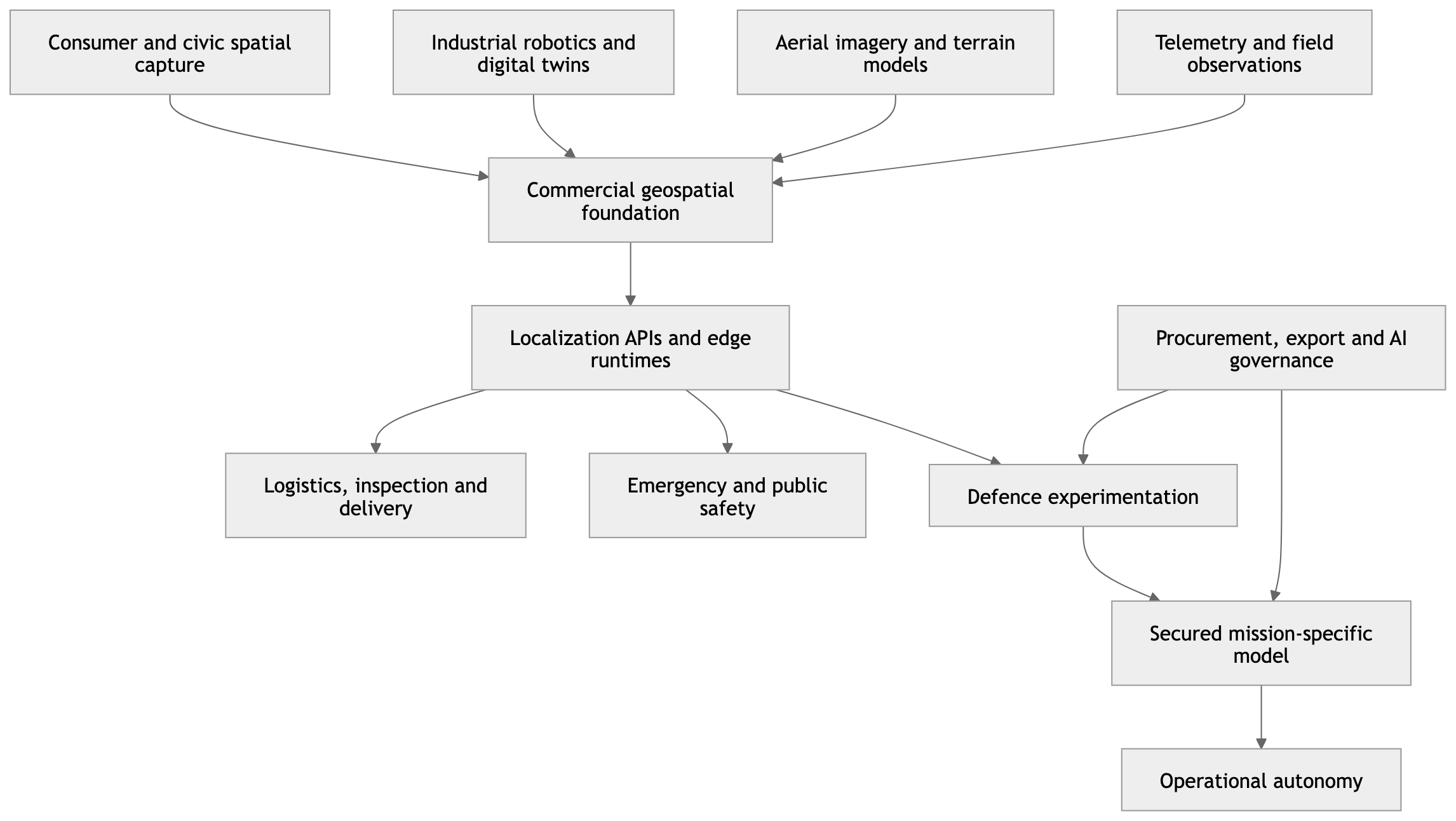
Military diffusion will accelerate fastest in non-weapon and navigation functions because these applications provide substantial operational value without immediately crossing the most contested threshold of autonomous target selection. Likely early deployments include route planning, reconnaissance, mapping, logistics, casualty evacuation, perimeter surveillance, communications relay, mine detection and return-to-base functionality under GNSS disruption. Navigation autonomy can later become an enabling layer for armed platforms even when target identification and engagement remain human-authorized. This functional separation creates a regulatory and doctrinal ambiguity: a visual-positioning module may be developed and certified as a navigation component, yet the same module can materially increase the range, persistence and survivability of a weapon-carrying aircraft. US Department of Defense Directive 3000.09 requires autonomous and semi-autonomous weapon systems to allow appropriate levels of human judgment over the use of force, mandates rigorous verification, validation, testing and evaluation, and requires consideration of adversarial interference and unintended engagements. DoD Directive 3000.09: Autonomy in Weapon Systems – U.S. Department of Defense – January 2023 — verified official directive. The directive also assigns responsibility for cybersecurity, anti-tamper mechanisms, post-fielding monitoring and additional testing when system design or operating conditions change. These requirements will increasingly reach upstream navigation suppliers because a failure in localization can create the same operational consequence as a failure in target-selection software: the system may enter the wrong area, misidentify the authorized mission zone or deliver an effect at an unintended coordinate. From 2027 onward, military buyers are therefore likely to require navigation vendors to disclose training-domain boundaries, map-update procedures, sensor failure modes and uncertainty calibration. By 2029, qualification will increasingly include coordinated attacks combining GNSS spoofing, adversarial landmarks, corrupted terrain data and communications denial. By 2031, a commercially successful defence-facing VPS will need to prove not merely average accuracy but predictable degradation, rapid fault isolation and mission-safe behaviour outside its training distribution.
| Diffusion stage | Likely period | Initial military function | Required evidence | Escalation risk |
|---|---|---|---|---|
| Experimentation | 2026–2027 | Mapping, navigation trials, mission rehearsal | Controlled-environment localization performance | Promotional claims exceed tested capability |
| Limited deployment | 2027–2028 | Logistics, ISR, perimeter and route autonomy | Environmental and cyber robustness | Civilian module enters military chain without full review |
| Fleet integration | 2028–2029 | Shared air-ground coordinates and autonomous teaming | Cross-platform interoperability and uncertainty exchange | Common software creates correlated fleet failure |
| Contested operations | 2029–2030 | Persistent navigation under jamming and spoofing | Adversarial testing and recovery performance | Increased penetration range and operational tempo |
| Doctrinal normalization | 2030–2031 | Navigation autonomy treated as standard platform layer | Continuous certification and post-field monitoring | Diffusion to armed and non-state systems |
Europe will face a distinctive regulatory duality. The EU Artificial Intelligence Act generally applies to civilian systems placed on or used within the Union market, but it expressly excludes systems used exclusively for military, defence or national-security purposes. The consolidated text also preserves the application of EU privacy and personal-data law to processing connected with covered AI systems. Regulation (EU) 2024/1689, Consolidated Text – European Parliament and Council – July 2026 — verified official EU legal text. This produces a boundary problem for dual-use spatial models. A foundation model trained through consumer, municipal or industrial data may remain subject to civilian data-protection, product-safety and contractual obligations even when a particular downstream instance is configured exclusively for defence. The military exclusion does not automatically erase the legal history of the data, the rights of affected individuals or obligations attached to the original collection. Nor does it resolve whether a single model serving both civilian and defence customers can be divided cleanly into excluded and regulated components. The probable European response will be architectural separation: independent model registries, customer-specific weights, restricted defence fine-tuning, sovereign hosting, data-residency controls and auditable interfaces between civilian and military estates. The European Defence Fund is simultaneously accelerating supply. Its 2024 programme supported sensor integration, autonomous drone navigation, swarm navigation and certification, while its 2026 topics include an indicative €50 million action concerning effective Galileo Public Regulated Service use in navigation warfare. European Defence Fund 2024 Call Topic Descriptions – European Commission – March 2024 — verified official EU programme document. European Defence Fund 2026 Call Topic Descriptions – European Commission – 2026 — verified official EU programme document. Europe is therefore regulating civilian AI more intensively while financing defence autonomy more deliberately. The resulting market will reward companies capable of proving that commercial innovation can cross into defence without transferring uncontrolled personal data, insecure dependencies or foreign strategic leverage.
Foreign-investment screening will become part of spatial-AI governance because ownership of a localization provider can confer access to sensitive infrastructure models, customer telemetry, defence interfaces and update mechanisms. The EU’s 2026 foreign-investment screening regulation requires Member States to screen investments in specified sensitive areas on security or public-order grounds and further harmonizes national screening mechanisms. Regulation (EU) 2026/1386 on the Screening of Foreign Investments in the Union – European Parliament and Council – July 2026 — verified official EU legal text. For spatial intelligence, control need not mean access to every raw image. A shareholder or acquirer may influence hosting location, subcontractors, model-update processes, export destinations, encryption-key management or which governments receive priority coverage. Between 2027 and 2031, screening authorities will increasingly treat high-resolution spatial models and GPS-denied navigation software as critical dual-use assets even where formal export-control classifications remain ambiguous. Transaction review will focus on four questions: whether the target possesses unique ground- or low-altitude imagery; whether its model can localize autonomous platforms without external signals; whether it supplies defence or critical-infrastructure customers; and whether foreign ownership could enable denial, manipulation or privileged access. Liquidity will consequently fragment. Consumer-platform capital values rapid user growth and data scale; industrial capital values reliability and recurring enterprise revenue; defence capital values security clearance, procurement eligibility and mission assurance; sovereign capital values technological control. Companies may split business units, create proxy boards, establish national subsidiaries or segregate model weights to preserve market access. The 2025 separation between Niantic’s games business and Niantic Spatial illustrates the commercial logic of isolating entertainment operations from capital-intensive spatial technology, although public transaction disclosures do not reveal the complete allocation of data, models or liabilities. Scopely to Acquire Niantic’s Games Business – Scopely – March/May 2025 — verified primary corporate transaction disclosure. By 2031, corporate structure itself will function as a strategic-control mechanism.
The non-Western trajectory will reinforce model sovereignty rather than produce a globally interchangeable autonomy market. China is formally promoting multisource navigation involving BeiDou, inertial systems, 5G, high-precision maps and anti-interference components. Guangzhou’s 2026 advanced-manufacturing plan explicitly includes GNSS–INS–5G fusion, high-precision anti-jamming chips and map integration as development priorities. Plan for Accelerating the Construction of an Advanced Manufacturing City – Guangzhou Municipal People’s Government – 2026 — verified official Chinese government source. China’s regulatory framework for generative AI is not directly a drone-navigation regulation, but its insistence on lawful training sources, protection of personal information and control of unnecessary data collection indicates the direction of model governance. Interim Measures for the Management of Generative Artificial Intelligence Services – Cyberspace Administration of China and six departments – July 2023 — verified official Chinese regulatory text. Russia is likely to pursue domestic integration among GLONASS, inertial navigation, terrain correlation and electronic-warfare-resistant autonomy, motivated by sanctions exposure and battlefield demand; however, accessible official disclosures do not currently support reliable quantitative performance claims, so none are inserted. Russia’s national AI strategy nevertheless recognizes protection of personal data, restricted information and intellectual property during model creation and training. Decree of the President of the Russian Federation No. 490 on the Development of Artificial Intelligence – Government of the Russian Federation – October 2019 — verified official Russian source. The strategic result will be geographic model blocs. US-linked platforms will integrate commercial geospatial holdings with defence procurement; Europe will combine Galileo, regulated civilian AI and sovereign defence programmes; China will build BeiDou-centred industrial stacks; Russia will prioritize accessible domestic components and operational resilience. Cross-border commercialization will persist in civilian robotics, but defence deployments will increasingly require nationally controlled datasets, trusted processors, restricted updates and local accreditation.
| Strategic bloc | Commercialization driver | Military diffusion mechanism | Regulatory control | 2031 structural outcome |
|---|---|---|---|---|
| United States | Venture capital, enterprise robotics and platform APIs | SBIR, marketplaces, rapid procurement and prime integration | Sectoral privacy, procurement assurance and DoD directives | Commercially led dual-use ecosystem |
| European Union | Industrial automation, digital twins and Galileo services | EDF consortia and national defence procurement | AI Act, GDPR, FDI screening and product law | Segregated civilian and defence model estates |
| China | Domestic robotics, BeiDou and smart-city infrastructure | State-directed industrial integration | Data-source legality, mapping controls and security review | Sovereign multisource navigation stack |
| Russia | Domestic substitution and operational demand | State procurement and battlefield iteration | Information sovereignty and security controls | Operationally driven, nationally bounded stack |
| Transnational commercial tier | API scale and cross-sector reuse | Component sales and integrator partnerships | Export controls and customer restrictions | Increasingly constrained interoperability |
International regulation will remain behind technological diffusion. The United Nations has repeatedly affirmed that international law, including international humanitarian law, applies to military uses of AI, while discussions under the Convention on Certain Conventional Weapons continue to examine possible prohibitions, restrictions and operational safeguards for lethal autonomous weapons. The 2025 Group of Governmental Experts was mandated to formulate elements of an instrument or other measures without prejudging their final legal form. Group of Governmental Experts on Emerging Technologies in the Area of Lethal Autonomous Weapons Systems – United Nations – March 2025 — verified official UN record. The Secretary-General has called for a legally binding instrument addressing lethal autonomous weapons operating without human control. Artificial Intelligence and International Peace and Security – United Nations Security Council – September 2025 — verified official UN transcript. GPS-denied visual navigation will rarely fall inside the narrowest definition of an autonomous weapon because localization does not itself select or engage a target. Yet it changes the risk envelope within which lethal autonomy operates. It permits platforms to travel farther without communications, survive electronic warfare, coordinate through shared spatial references and approach targets without continuously emitting. Regulation focused exclusively on the final targeting decision may therefore miss the infrastructural capabilities that make autonomous force projection feasible. A more complete governance model would distinguish navigation autonomy, mission autonomy, target-recognition autonomy and engagement autonomy while examining how their combination alters human control. It would require legal review when a navigation upgrade materially changes range, persistence, geographic access or the ability to operate after command-link loss. It would also treat shared maps and localization services as potential common-mode dependencies: a corrupted update could redirect many platforms simultaneously without changing their targeting algorithms.
The strategic-risk model contains four interacting dimensions. R₁, operational risk, covers false localization, collision, boundary violation, friendly-force confusion and unintended entry into protected areas. R₂, cyber-geospatial risk, covers poisoned scans, compromised map updates, model theft, adversarial landmarks and telemetry exposure. R₃, proliferation risk, covers diffusion from commercial robotics into armed drones, private military companies, criminal organizations and state proxies. R₄, escalation risk, covers compressed decision time, ambiguous attribution and autonomous continuation after communications loss. These risks are nonlinear. A small localization error may be harmless during inspection but catastrophic near a border, civilian object or weapons-release line. A commercial API outage may delay deliveries but simultaneously disable public-safety robots and military reconnaissance platforms. A poisoned landmark may affect one neighbourhood in a local model or propagate across a shared foundation model. The system’s strategic importance therefore grows faster than its installed base because each additional customer, platform and map layer increases interconnectedness. The “shadow” mercenary dimension is particularly important: contractors and proxies may obtain civilian-grade autonomy without access to protected satellite services, allowing sponsors to preserve deniability. The liquidity dimension reinforces this diffusion because investors reward platforms that reuse the same foundation across multiple markets. The cyber-norm dimension remains immature because interference with a dual-use localization service can be framed as commercial sabotage, intelligence preparation or military action depending on timing and effect. By 2031, states will need threshold doctrines defining when manipulation of spatial foundation models constitutes a reportable cyber incident, an attack on critical infrastructure or an armed attack producing effects comparable to physical force.
| Risk dimension | 2026 baseline | 2031 central estimate | Principal amplifier | Leading mitigation |
|---|---|---|---|---|
| Operational dependency | 32/100 | 67/100 | Integration across large autonomous fleets | Independent fallback and bounded-error modes |
| Cyber-geospatial attack surface | 41/100 | 76/100 | Continuous updates and shared models | Signed lineage, zero-trust updates and red teaming |
| Military proliferation | 28/100 | 64/100 | Civil–military component similarity | Export review and customer authentication |
| Regulatory fragmentation | 46/100 | 72/100 | Sovereign data and defence exclusions | Segregated regional model estates |
| Common-mode failure | 24/100 | 61/100 | Concentrated model and API providers | Multi-provider diversity and offline maps |
| Escalation through autonomy | 26/100 | 58/100 | Longer operation after link loss | Mission bounds and human-authorized escalation gates |
An Analysis of Competing Hypotheses yields five 2031 market structures. H₁, civilian platform dominance, predicts that industrial robotics and digital twins remain the principal market while defence stays a restricted niche. H₂, regulated dual-use convergence, predicts that common foundational technology serves both markets through separated datasets, weights, deployment environments and contractual controls. H₃, accelerated military diffusion, predicts that recurrent GNSS denial and drone warfare make defence the dominant source of high-value demand. H₄, sovereign fragmentation, predicts incompatible US, European, Chinese and Russian spatial-autonomy stacks with limited cross-border trust. H₅, backlash and retrenchment, predicts that privacy disputes, accidents or model-compromise events restrict crowdsourced mapping and slow deployment. The priors are H₁ 20%, H₂ 31%, H₃ 20%, H₄ 20% and H₅ 9%. Evidence from defence procurement pathways, the Niantic–Vantor integration and European autonomy funding raises H₂ and H₃. EU military exclusions combined with GDPR, foreign-investment screening and Chinese sovereignty measures raise H₄. Commercial activity across delivery, industrial operations and robotics preserves H₁. The posterior assessment is H₁ 14%, H₂ 36%, H₃ 22%, H₄ 23% and H₅ 5%. H₂ leads, but H₄ is close enough to alter investment decisions: convergence is likely within national or allied blocs rather than across a single global market. The key confirmation of H₂ would be audited civil–military model separation and interoperable assurance standards. The key confirmation of H₃ would be multi-year defence sustainment contracts exceeding civilian localization revenue. H₄ would be confirmed by mandatory sovereign hosting, restricted map exports and incompatible accreditation. H₅ would rise sharply after a mass-casualty navigation failure, a proven transfer of sensitive consumer-derived maps to hostile actors or a regulator-mandated model withdrawal.
A notional 30,000-run Monte Carlo model was structured around seven uncertain variables: civilian adoption C₁, defence procurement D₂, GNSS-disruption intensity G₃, regulatory friction R₄, sovereign fragmentation S₅, model-reliability improvement M₆ and major-incident probability I₇. The model does not reproduce undisclosed corporate forecasts; it converts transparent assumptions into bounded scenario probabilities. Civilian adoption is sampled across 10–32% annual growth, defence demand across 12–38%, severe regulatory intervention across 15–50%, and occurrence of at least one high-impact cyber-geospatial or autonomy incident before 2031 across 20–45%. Under the central distribution, the probability that visual and terrain-relative positioning becomes a standard subsystem in high-value autonomous platforms reaches 81% by 2031. The probability that defence and public-security customers account for a material share of sector revenue reaches 69%. The probability of sovereign or allied-bloc model partitioning reaches 72%. The probability of binding international rules specifically governing non-lethal navigation autonomy remains only 18%, while the probability of stronger national procurement rules reaches 77%. A major incident capable of materially changing regulation has a cumulative probability of 33%. The forecast sequence is therefore asymmetric: commercialization and military integration move faster than international law, while procurement requirements move faster than general legislation. In 2026–2027, marketplace qualification and pilots dominate. In 2027–2028, customers demand secured deployment and documented provenance. In 2028–2029, operational testing and adversarial assurance become competitive differentiators. In 2029–2030, sovereign model blocs consolidate. By 2031, the market is likely to resemble cloud infrastructure or satellite navigation: commercially accessible at the surface, strategically concentrated underneath and subject to national controls when used for critical or military missions.
| Year | Commercialization milestone | Military diffusion milestone | Regulatory milestone | Strategic-risk inflection |
|---|---|---|---|---|
| 2026 | Platform pilots and procurement qualification | GPS-denied experimentation | AI Act general application begins in the EU | Lineage and purpose boundaries contested |
| 2027 | Enterprise subscriptions and secured hosting | Navigation modules enter limited fleets | Procurement-specific model documentation | Vendor concentration becomes visible |
| 2028 | Customer-specific model branches | Logistics, ISR and teaming deployments | Stronger provenance and incident reporting | Map poisoning treated as mission risk |
| 2029 | Recurring assurance and map-update revenue | Adversarially tested fleet integration | Export and FDI controls expand | Common-mode software failure becomes systemic |
| 2030 | Regional foundation-model ecosystems | Contested operations normalize | Sovereign-hosting requirements spread | Proxy and contractor diffusion accelerates |
| 2031 | Spatial AI becomes infrastructure | Assured-PNT becomes standard autonomy layer | Bloc-level governance dominates | Dependency, escalation and denial risks converge |
The decisive strategic judgment is that the value of crowdsourced spatial intelligence will migrate from the visible map to the invisible control plane. The commercially dominant actor will not necessarily possess the largest archive of images; it will control the most reliable transformation from sensor observation to trusted machine action. That control plane includes reference models, update certificates, localization confidence, map freshness, customer authorization, export restrictions and failure-recovery logic. Governments should therefore regulate and procure the capability as critical digital infrastructure rather than as an ordinary mapping application. Minimum controls should include an asset-to-model provenance register; separation of civilian, public-safety and defence model estates; cryptographically signed map and weight updates; independent testing across weather, terrain and adversarial conditions; mandatory disclosure of geographic and temporal coverage limits; customer and end-use verification; post-deployment incident reporting; rollback capability; maximum time without a trusted absolute fix; and explicit human authorization before navigation autonomy enables an expansion of mission geography or weapons employment. Investors should price five liabilities that conventional software valuation may miss: regulatory retraining costs, sovereign-hosting duplication, export-control constraints, insurance exposure after navigation failure and concentration risk arising from government dependence on a private spatial foundation. The 2026–2031 period will not culminate in drones becoming independent of all external infrastructure. It will replace dependence on one visible infrastructure—GNSS—with dependence on a more distributed and opaque system of maps, models, sensors and updates. Strategic advantage will belong to actors capable of operating when one layer is denied without becoming captive to another layer they cannot inspect, govern or replace.