















The 29B6 Container Programme, Over-the-Horizon Surveillance, Early-Warning Integration and the Strategic Consequences of Russia’s Expanding Intelligence Infrastructure in the Karaliaučius Region
Scope: This assessment examines Russian over-the-horizon radar infrastructure development in the Karaliaučius (Kaliningrad) exclave between the reported commencement of construction in March 2023 and 26 October 2026, evaluating its implications for NATO situational awareness, European air surveillance, intelligence integration and crisis decision-making over a five-year analytical horizon extending to October 2031.
Executive Summary — Bottom Line Up Front
The central strategic judgment is that Russia’s reported expansion of over-the-horizon radar infrastructure in the Karaliaučius exclave represents a potentially consequential strengthening of its European intelligence and early-warning architecture, but the available evidence does not yet establish an equivalent improvement in operationally available surveillance capability. The significance of the programme lies in the prospective combination of long-range airborne-activity detection, intelligence fusion and shorter warning-to-decision intervals, rather than in nominal radar coverage alone.
The Lithuanian intelligence services’ March 2026 National Threat Assessment establishes that elements of the 29B6 Container system are being constructed at multiple locations in the exclave. Its assessment identifies long-range airspace monitoring as the facility’s intended function and places the development within Russia’s continuing military infrastructure expansion near NATO territory.
Satellite imagery discussed in the Robert Lansing Institute assessment of 21 October 2026 provides further evidence of construction near Gvardeysk, approximately 37 kilometres from the Polish border. Three antenna arrays, each exceeding 500 metres, have been reported, with construction activity dating from approximately March 2023. A separately identified circular feature near Chernyakhovsk remains insufficiently characterised to establish its function or relationship with the radar programme.
The reported Container system exploits high-frequency radio-wave propagation through ionospheric reflection and is associated with a potential detection range of approximately 3,000 kilometres against selected airborne targets. This is a reported system characteristic, not verified performance of the installation under construction.
If the facility becomes operational and its outputs are effectively integrated with other Russian intelligence, surveillance and reconnaissance systems, it could improve the detection of changes in Allied aviation patterns across parts of Northern, Central and Western Europe. Such information could strengthen strategic warning, support military planning and reduce uncertainty for Russian command authorities.
The decisive distinction is between detecting an airborne event, interpreting its operational significance and delivering sufficiently reliable information for military decision-making. Radar construction establishes neither continuous surveillance of all targets nor the existence of an integrated, validated operational intelligence capability.
For NATO, the principal requirement is therefore to assess the emerging Russian sensor network as an evolving intelligence system while preserving resilient Allied ISR arrangements, reliable warning processes and the capacity to distinguish observable military activity from hostile intentions.
Russia’s 3,000-Kilometre Radar Ambition: How Kaliningrad Could Change NATO’s Intelligence Balance
Russia’s expansion of long-range radar infrastructure in Kaliningrad presents NATO with a defence-policy contradiction: European governments are committing more resources to military readiness while Moscow is investing in the ability to observe the activity those resources generate. Lithuania’s March 2026 intelligence assessment confirmed construction of elements of the 29B6 Container radar system, while satellite analysis published on 21 October documented extensive antenna infrastructure near Gvardeysk. The installation is not confirmed operational, yet its potential consequences already extend beyond the Baltic states. A radar designed to detect selected airborne targets at distances approaching 3,000 kilometres could provide Russian commanders with earlier indications of Allied military movements. The decisive issue is not whether Russia can build a more powerful radar, but whether it can convert additional observations into reliable intelligence faster than NATO can preserve its operational and decision-making advantage.
The evidence is substantial, but operational superiority remains unproven
The distinction between construction and capability is central to understanding Moscow’s investment. In the National Threat Assessment 2026, published on 6 March, Lithuania’s Defence Intelligence and Security Service and State Security Department identified work on the 29B6 Container system at several locations in the Kaliningrad exclave. The intelligence assessment, based on information available up to 6 February, placed the project alongside other Russian military infrastructure, including the Voronezh-DM missile-warning radar, an arsenal with reinforced storage facilities and a strategic-reserve logistics base. Its importance was institutional as well as technical: Russia was continuing to develop permanent military infrastructure even as the war in Ukraine constrained the availability of some conventional forces previously stationed in the region. National Threat Assessment 2026 — Lithuanian Intelligence Services — March 2026.
The satellite-derived analysis published by the Robert Lansing Institute on 21 October 2026 added a physical dimension to that assessment. Near Gvardeysk, approximately 37 kilometres from the Polish border, investigators reported three extensive antenna arrays, each exceeding 500 metres, in a configuration described as star-shaped. Construction activity reportedly dates to approximately March 2023. A separate circular structure near Chernyakhovsk, exceeding 1.6 kilometres in diameter, remains unidentified in functional terms. These findings indicate a substantial, multiyear undertaking, but they do not conclusively establish the relationship between every observed structure and the Container architecture. Nor do they establish a date for operational commissioning. Russia Expands Radar Surveillance of Europe — Robert Lansing Institute — October 2026.
This evidentiary distinction should govern NATO’s assessment. A physical installation may be substantially complete without delivering reliable military information. The Container programme represents an intended expansion of Russian surveillance capacity; it does not yet constitute demonstrated Russian intelligence superiority. Confusing those stages would risk directing European defence expenditure towards a capability whose practical effects remain unmeasured.
Three thousand kilometres would expand observation, not guarantee military knowledge
The reported 29B6 Container characteristics include a potential detection range of approximately 3,000 kilometres and an angular surveillance sector described as reaching 240 degrees. The underlying technology uses high-frequency electromagnetic waves propagating through the ionosphere, allowing selected airborne activity to be detected beyond conventional radar horizons. In strategic terms, the geographical importance of Kaliningrad could therefore extend beyond Poland, Lithuania and the immediate Baltic airspace into a much wider European military environment.
But neither nominal range nor antenna dimensions establish continuous coverage. Ionospheric conditions change; interference, background noise and unwanted radar returns affect detection; and observations must be processed before their significance can be understood. The Gvardeysk installation’s actual surveillance geometry, reliability and capacity to distinguish individual targets remain unverified. A radar return indicating distant airborne activity cannot automatically establish aircraft nationality, mission or intention. Even a functioning long-range sensor would not independently provide the precision required for every air-defence or engagement function.
Its more consequential contribution could be cumulative. Repeated observations might help Russian intelligence identify changes in Allied aviation patterns, including shifts in the scale, timing or geographical distribution of military activity. Such information could become relevant to assessments of readiness and reinforcement without revealing the full purpose of individual flights. Yet an exercise, a precautionary deployment and preparations for a more serious contingency can share observable characteristics. The ability to detect a change is not equivalent to the ability to explain it.
This is where surveillance becomes an institutional rather than exclusively technological question. Additional observations are useful when they are reliable, independently corroborated and delivered to the authorities responsible for military decisions. The prospective Russian advantage would arise from the intelligence produced after detection, not from the distance over which electromagnetic signals can travel.
NATO has aircraft and intelligence networks; Russia is seeking additional warning depth
NATO is not confronting the proposed Russian radar with an empty surveillance architecture. As of July 2026, the Alliance documented 14 E-3A AWACS aircraft based at Geilenkirchen, Germany, providing airborne surveillance, command and control. Its Intelligence, Surveillance and Reconnaissance Force operates five RQ-4D Phoenix aircraft from Sigonella, Italy, while performing wider intelligence-processing and dissemination functions. In June 2026, two RQ-4D aircraft operated from Finland during Exercise Ramstein Flag, demonstrating the geographical flexibility of an established multinational collection organisation. NATO Intelligence, Surveillance and Reconnaissance Force — NATO — 2026.
On 7 July 2026, Denmark, Finland, Germany and Norway announced the procurement of up to five MQ-4C Triton aircraft, designed for maritime surveillance missions lasting approximately 24 hours at altitudes exceeding 15 kilometres. The programme involves Northrop Grumman, Airbus Defence and Space and other European industrial participants. It illustrates how intelligence requirements translate into procurement, industrial integration, ground infrastructure and future operating expenditure. But the announced aircraft are not equivalent to delivered capability, just as Russian radar construction is not equivalent to operational surveillance. Both sides must convert investment into functioning systems before the promised military effects can be realised. NATO Expands Its ISR Fleet with Triton Aircraft — NATO — July 2026.
The more difficult comparison concerns information integration. NATO’s Joint Intelligence, Surveillance and Reconnaissance framework combines collection, analysis and dissemination across national and Alliance institutions, although technological differences and national restrictions continue to constrain information sharing. Russia could obtain additional warning from Container if radar observations were effectively combined with other surveillance and electronic intelligence sources. Lithuania has documented Russian electronic warfare activity in Kaliningrad, while October reporting described more than twenty additional electronic intelligence and electronic warfare sites identified through satellite analysis. Their presence does not establish a unified Russian network. It does, however, underline the distinction between acquiring more sensors and creating a more effective intelligence system.
The contest is consequently not between a Russian radar and a NATO aircraft fleet. It is between intelligence organisations seeking to produce sufficiently accurate information, quickly enough, to influence military decisions. No public evidence yet establishes that the new Russian installation has shifted that balance.
Europe’s defence commitments are multiplying the activities Moscow wants to understand
The European stakes are unequal because NATO members occupy different positions in the Baltic military structure. Germany is making the most consequential permanent force-stationing commitment examined in the dossier. Its brigade programme in Lithuania envisages approximately 5,000 military and civilian personnel and 2,000 vehicles, with full operational capability planned by the end of 2027. The Lithuanian Ministry of National Defence confirmed on 3 October 2026 that implementation was continuing, with major relocation activity expected during 2027. The programme connects German defence policy with Lithuanian infrastructure, logistics and the wider Allied military presence. A future Russian long-range radar would not reveal the brigade’s readiness by itself, but selected supporting aviation activity could contribute information relevant to Moscow’s interpretation of NATO reinforcement. German Brigade Stationing Update — Lithuanian Ministry of National Defence — October 2026.
Poland faces a different exposure. Its Eastern Shield programme, established in June 2024 with an initial financial framework of approximately PLN 10 billion for 2024–2028, was subsequently described by the Polish Ministry of National Defence in August 2026 within an expanded financing framework of approximately PLN 40 billion. The programme covers fortifications, military support infrastructure, observation and warning capabilities. The revised figure should not be confused with expenditure already completed. Nor is Eastern Shield a direct technological answer to Container. Poland is strengthening territorial defence and detection arrangements; Russia is developing a possible means of observing airborne activity at much greater distances. The two programmes reflect different requirements within the same deteriorated regional security environment. Eastern Shield Programme — Polish Government — June 2024.
France and the United Kingdom illustrate why distance from Kaliningrad is an inadequate measure of strategic exposure. France deployed four Rafale B aircraft and approximately 100 personnel to Lithuania between April and August 2026 for Baltic Air Policing. The United Kingdom announced a new defence roadmap with Estonia on 16 July 2026, envisaging a British presence of approximately 1,200 personnel. Both commitments connect national military resources with the operational security of NATO’s eastern flank. Neither establishes that the Russian radar can already observe those forces, but both explain why changes in Russian surveillance merit multinational attention. Baltic Air Policing 2026 — French Ministry of the Armed Forces — March 2026; UK–Estonia Defence Roadmap — UK Ministry of Defence — July 2026.
Italy occupies another position in the same structure. Through Sigonella, it hosts the NATO ISR Force and the infrastructure supporting Alliance-owned RQ-4D aircraft. Its significance is not primarily a presumed direct exposure of Italian airspace to the Russian radar. It lies in the dependence of NATO’s intelligence system on geographically distributed bases, national support arrangements and multinational information processing. Lithuania supplies the official threat assessment; Poland protects an exposed frontier; Germany, France and Britain contribute different forms of regional military presence; Italy supports an important component of Allied surveillance. A common European response cannot ignore these differences.
Defence budgets are rising faster than demonstrated intelligence interoperability
The fiscal constraint is becoming more demanding. At the June 2025 Hague Summit, NATO Allies committed to annual defence and security expenditure reaching 5% of GDP by 2035, including at least 3.5% for core defence requirements and up to 1.5% for broader security-related expenditure, including resilience and critical infrastructure. A review is scheduled for 2029. The target establishes a substantial long-term commitment, not proof that additional funding has already generated operational capabilities. For intelligence policy, this distinction matters because aircraft procurement, infrastructure investment, data integration and communications resilience produce different results and follow different implementation schedules. Defence Investment and NATO’s 5% Commitment — NATO — June 2026.
NATO’s 2026 Resilience Baseline Requirements, published on 15 September, identify seven areas of national preparedness, including government continuity, energy, civil communications, transport and essential services. Their relevance to military intelligence is direct: even accurate surveillance information loses practical value if it cannot be communicated, interpreted or acted upon through functioning institutions. The requirements assign important responsibilities to national governments, making intelligence resilience a matter of civilian infrastructure and public administration as well as defence procurement. 2026 Resilience Baseline Requirements — NATO — September 2026.
The tension is structural. European governments can increase expenditure on visible military equipment while leaving weaknesses in interoperability, analytical capacity or supporting infrastructure unresolved. Conversely, investments in common intelligence processing and resilient communications may improve military decision-making without producing an equally visible addition to national inventories. The reported Russian radar does not establish that NATO has failed in either area. It makes the distinction more consequential because the prospective Russian benefit depends precisely on the ability to integrate observations into usable intelligence.
The European Union and NATO also have different responsibilities. NATO provides the collective military framework for air defence, intelligence coordination and operational planning; EU institutions and national governments have complementary responsibilities concerning infrastructure, resilience and industrial cooperation. Treating these authorities as interchangeable would obscure who can make decisions, allocate resources and deliver results. The 2029 NATO investment review provides a future institutional test of implementation, but the intelligence question must be assessed through operational evidence rather than expenditure percentages alone.
The next 24 months will test whether construction becomes intelligence power
Between October 2026 and October 2028, the most important Russian development would not be another announcement of antenna dimensions. It would be credible evidence that the Container installation has entered operational service, produces reliable long-range observations and contributes intelligence that Russian authorities can exploit. Confirmation of commissioning would establish progress beyond construction. Sustained detection performance would establish practical collection value. Demonstrated integration into military assessments would provide the strongest basis for concluding that Moscow has improved its knowledge of selected Allied aviation activity. None of these milestones currently has a confirmed public timetable.
The same period will test the implementation of European commitments already made. Germany’s brigade in Lithuania is scheduled to achieve full operational capability by the end of 2027; Poland’s original Eastern Shield period extends through 2028; NATO’s announced surveillance acquisitions and September 2026 resilience requirements create further obligations involving procurement, infrastructure and institutional coordination. These programmes cannot be judged by the scale of their announcements. They must be assessed by the capabilities delivered and the quality of the military information they support.
The cost of inaction would fall on NATO military authorities and the governments financing and operating Allied defence infrastructure. If Russian surveillance improves while information-sharing weaknesses and resilience deficiencies persist, European states could incur higher expenditure without obtaining proportionately better warning or decision-making. Conversely, premature investment based on an unverified Russian capability could divert funding from existing commitments. The strategic choice for NATO is not whether to match Russia’s radar ambitions, but whether to ensure that its intelligence system remains more effective at converting information into decisions. That result will be determined by operational readiness, integration and institutional performance—not by the largest antenna or the longest advertised detection range.
Navigational Index — Three Strategic Pillars
PILLAR I — PHYSICAL INFRASTRUCTURE AND THE STRATEGIC GEOGRAPHY OF SURVEILLANCE
- Chapter 1. Russian Radar Expansion in Karaliaučius: Documentary Evidence, Construction History and Strategic Context
- Chapter 2. The 29B6 Container System: Propagation Principles, Detection Potential and Technical Limitations
- Chapter 3. Gvardeysk, Chernyakhovsk and the Geography of Russia’s Baltic Intelligence Infrastructure
PILLAR II — INTELLIGENCE INTEGRATION AND THE OPERATIONAL BALANCE
- Chapter 4. From Radar Detection to Strategic Warning: Intelligence Production and Operational Decision-Making
- Chapter 5. Sensor Fusion, Electronic Intelligence and Russian Command-and-Control Integration
- Chapter 6. NATO Aviation Patterns, Operational Exposure and the Changing Intelligence Balance
- Chapter 7. The Baltic Crisis Environment: Information Advantage, Early Warning and Escalation Dynamics
PILLAR III — ALLIED RESPONSES, STRATEGIC UNCERTAINTY AND THE FUTURE BALANCE
- Chapter 8. NATO’s Intelligence and Surveillance Posture: Resilience, Coordination and Operational Adaptation
- Chapter 9. European Strategic Exposure: Germany, Poland, Lithuania, France, the United Kingdom and Italy
- Chapter 10. Operational Readiness, Competing Development Pathways and the 2026–2031 Outlook
- Chapter 11. Institutional Decision Requirements, Collection Priorities and Strategic Risk Management
- Chapter 12. Final Net Assessment: The Conditions for a Material Shift in Russian Situational Awareness
Master Abstract
The strategic meaning of Russia’s emerging surveillance infrastructure
The construction of substantial radar infrastructure in the Karaliaučius exclave introduces a developing intelligence dimension into the military balance between Russia and NATO in the Baltic theatre. Although the region’s military significance has traditionally been assessed through its geographical position, military installations and proximity to Allied territory, the reported expansion of long-range surveillance infrastructure requires attention to a different mechanism of strategic advantage: the ability to observe military activity at distance, identify departures from established patterns and translate warning information into decisions before an unfolding operation reaches its decisive phase. This prospective capability does not itself increase Russian combat power or establish superiority over NATO intelligence systems. Its importance derives from the possibility that, once operational, the new infrastructure could reduce information gaps that currently affect Russian assessments of Allied aviation activity and military preparations.
The documentary baseline is unusually important because the available reporting combines evidence of infrastructure construction with claims about intended capability that must not be treated as interchangeable. Lithuania’s Defence Intelligence and Security Service and State Security Department, in their jointly published 2026 National Threat Assessment, identified construction of the 29B6 Container over-the-horizon radar at several locations in the exclave. The assessment characterised the facility as intended to detect aircraft and missiles at distances of several thousand kilometres. This is an official intelligence judgment about a developing system, not a declaration that the infrastructure has entered operational service. Lithuania’s Ministry of National Defence presented the annual assessment on 6 March 2026, following an intelligence information cut-off of 6 February. The October satellite reporting therefore adds observations subsequent to the Lithuanian assessment’s underlying information period.
The October evidence adds a more concrete physical dimension to the assessment. The Robert Lansing Institute’s analysis, published on 21 October 2026 and drawing upon reported ICEYE satellite observations, describes three major antenna arrays near Gvardeysk, arranged in a star-shaped configuration, with each array exceeding 500 metres in length. The reported location, approximately 37 kilometres from the Polish border, places this infrastructure within a geographically sensitive Russian exclave adjoining NATO territory. Construction is reported to have begun around March 2023. These observations support the existence of a sustained and substantial infrastructure project, but they do not independently resolve every question concerning the system’s precise configuration, technical readiness or relationship with other nearby installations. In particular, the separately reported circular feature near Chernyakhovsk, described as exceeding 1.6 kilometres in diameter, requires independent functional identification before it can be assigned to the same surveillance architecture.
The transmission mechanism from sensor coverage to intelligence advantage
The proposed intelligence advantage begins with the technical characteristics associated with over-the-horizon radar. Unlike a conventional line-of-sight radar, an ionospheric-reflection system uses high-frequency radio waves propagating beyond the geometric horizon, potentially allowing detection of airborne activity across extensive distances. The reported 29B6 Container detection range of up to approximately 3,000 kilometres establishes the potential geographical scale of the programme but does not define its actual coverage, surveillance reliability or target discrimination in the Baltic configuration. Such performance depends on propagation conditions, interference, operating parameters and the characteristics of the target being observed. A long nominal detection range therefore cannot be equated with uninterrupted observation, precise tracking or the capacity to support weapon engagements without additional sensors and processing systems.
The more consequential military possibility is the accumulation of observations over time. If operationally reliable data from the installation allow Russian analysts to establish patterns of Allied aviation activity, subsequent changes in the frequency, scale or geographical distribution of those activities could acquire intelligence significance. Increased movement of military aircraft, unusual concentration of supporting aviation assets or changes in the timing of operations might provide indicators relevant to assessments of readiness or reinforcement. The analytical value would arise not from a single radar return but from the comparison of successive observations with an established baseline and with information obtained from other collection disciplines. This also defines a fundamental limitation: identifying an unusual pattern does not establish the intention behind it. Training, exercises, precautionary deployments and preparations for possible combat may share observable features, and misinterpretation of those features could diminish rather than improve the quality of strategic warning.
The integration question is therefore central to the assessment. A radar capable of long-range detection can contribute to strategic situational awareness only if its data can be processed, evaluated, correlated with independent information and delivered to the appropriate command authorities in a form that supports timely judgment. Combining over-the-horizon observations with other radar information, electronic intelligence collection and air-defence surveillance networks could increase confidence in the identification of operational developments. The resulting improvement might be particularly relevant where individual sensors provide incomplete or ambiguous information. Nevertheless, neither the existence of multiple collection installations nor their geographical proximity demonstrates that they already function as an interoperable, automated intelligence network. Data quality, communications reliability, correlation procedures and command-level exploitation remain necessary conditions for converting technical detection potential into an operational advantage.
Karaliaučius and the changing Baltic intelligence environment
The geographical importance of the reported infrastructure extends beyond the immediate Baltic airspace. A Russian surveillance facility positioned in Karaliaučius and operating at the reported ranges could contribute observations relevant to Allied aviation activity in a much wider European theatre, subject to its actual coverage geometry and operational performance. The significance for NATO is not that every Allied aircraft would become continuously observable, but that a new source of long-range indications could complicate the assumption that activities conducted beyond the immediate Baltic region are necessarily outside Russian surveillance awareness. The potential relevance of movements across Germany, France and the United Kingdom follows from the reported continental reach, although their actual exposure cannot be established without verified operational coverage data. For Italy, the principal implications are less about an assumed direct radar footprint than about intelligence sharing, NATO reinforcement planning and the management of European air activity within a common Alliance operational architecture.
This development must also be understood against the broader military trajectory described by Lithuanian intelligence. The March 2026 assessment reported Russia’s continuing development of military infrastructure in the exclave while also identifying temporary limitations in its local land-force posture arising from the war against Ukraine. It identified additional facilities, including the Voronezh-DM early-warning radar, alongside the Container construction programme. This combination indicates that the evolution of Russia’s regional surveillance infrastructure cannot be inferred solely from the immediately available strength of its conventional ground forces. Infrastructure investment can advance even when force-generation constraints remain significant. The result is an increasingly important distinction between Russia’s current ability to conduct military operations and its prospective ability to observe, anticipate and interpret NATO activity.
The strategic question for NATO is consequently not whether the reported radar installation possesses an impressive theoretical range, but whether its eventual operation would materially alter the relationship between Russian observation, warning and decision-making. Three conditions are decisive. The installation must first become technically and operationally capable of generating useful observations. Its outputs must then be integrated into a wider intelligence architecture sufficiently reliable to discriminate meaningful developments from routine activity. Finally, the information must reach Russian decision-makers with sufficient timeliness and credibility to influence planning or crisis decisions. Failure at any of these stages would constrain the strategic effect, even if the physical infrastructure were complete. Conversely, credible evidence of successful performance across all three stages would support a substantially stronger assessment of the programme’s consequences for the European intelligence balance.
The present record supports a clear directional judgment without establishing that threshold has already been crossed. Russia is investing in infrastructure intended to expand long-range monitoring of European airspace from a strategically significant position adjoining NATO territory. The construction observations reinforce the official Lithuanian assessment of a continuing programme, but the available documentation does not establish its operational readiness, verified detection performance or degree of network integration. The appropriate institutional response is to treat the development as a consequential emerging intelligence capability, to preserve the distinction between physical construction and effective surveillance, and to evaluate future evidence according to whether it demonstrates a genuine increase in Russia’s capacity to convert distant observations into timely, reliable military knowledge.
Key Evidence Table
| Indicator | Value / status | Reference date | Definition / scope | Issuer | Exact source |
|---|---|---|---|---|---|
| 29B6 Container construction | Confirmed as ongoing in several locations | March 2026 | Long-range radar infrastructure | Lithuanian AOTD/VSD | National Threat Assessment 2026, p. 18 |
| Location of major arrays | Near Gvardeysk, approximately 37 km from Polish border | October 2026 | Reported geographical proximity | Robert Lansing Institute / satellite-derived reporting | RLI, 21 October 2026 |
| Antenna configuration | Three arrays, each over 500 m | October 2026 | Reported physical layout | ICEYE observations reported by RLI | RLI, 21 October 2026 |
| Construction commencement | Approximately March 2023 | Retrospective observation | Reported start of construction activity | Satellite-derived reporting | RLI, 21 October 2026 |
| Detection range | Up to approximately 3,000 km | Reported October 2026 | Nominal capability against selected airborne targets, not verified site performance | RLI | RLI, 21 October 2026 |
| Chernyakhovsk circular feature | Reported diameter exceeding 1.6 km; function unresolved | October 2026 | Separate feature requiring identification | RLI | RLI, 21 October 2026 |
| Operational readiness | No confirmed date | 26 October 2026 | Commissioning and operational availability not established | Public reporting | RLI, 21 October 2026 |
| Network integration | Not publicly demonstrated | 26 October 2026 | Operational fusion with other ISR and command systems remains unresolved | Analytical assessment | Lithuanian NTA 2026 and RLI, 21 October 2026 |
Evidence classifications distinguish official intelligence assessments from satellite-derived reporting and analytical inferences. The reported 3,000 km figure must not be interpreted as measured performance at Gvardeysk.
Competing Development Pathways and Their Strategic Implications
The available evidence does not justify a numerical probability model or a formal analysis of competing hypotheses concerning Russian operational intent. It does, however, support distinguishing alternative development pathways that would produce materially different outcomes for the intelligence balance.
One pathway involves continued infrastructure development without a corresponding near-term improvement in usable intelligence. Under this outcome, construction could proceed while technical commissioning, calibration, operational reliability or integration with other surveillance systems remained incomplete. The visible infrastructure would demonstrate investment and strategic commitment, but NATO would not necessarily face a material new surveillance capability.
A second pathway would involve the establishment of an operational radar capability that supplies additional long-range indications while remaining dependent on existing Russian collection and command arrangements. This could improve the breadth of Russia’s warning information, particularly when monitoring broader aviation patterns, without demonstrating the ability to maintain reliable individual-target tracking or significantly reduce military decision times.
The most consequential pathway would involve effective operational integration. Under this condition, reliable long-range radar observations would be correlated with other intelligence sources and delivered in time to influence military assessments. Russia could then gain improved awareness of changing Allied aviation patterns and greater confidence in interpreting significant activity before it reaches the immediate Baltic operational environment. The degree of advantage would nevertheless depend on the quality of the complete intelligence process, rather than on the radar’s advertised characteristics alone.
These pathways should not be treated as mutually exclusive permanent outcomes. They represent possible stages or limitations in capability development. The purpose of distinguishing them is to prevent the observation of infrastructure growth from being mistaken for evidence that the final operational effects have already materialised.
Principal Intelligence Gaps and Watch Indicators
The most important unresolved issue is the relationship between the radar structures visible near Gvardeysk and the precise configuration of the 29B6 Container architecture described in the Lithuanian intelligence assessment. The official documentation establishes a programme involving several locations, while the October reporting provides observations of major antenna infrastructure. It does not fully reconcile the system’s constituent sites, roles and relationships. Further authoritative technical identification or sufficiently documented imagery analysis would materially strengthen that connection.
A second gap concerns operational readiness. Physical completion, equipment installation, initial testing and sustained operational service represent distinct evidentiary thresholds. The available reporting establishes no verified commissioning date. Future official intelligence assessments, reliable evidence of operational testing or documented statements concerning service entry would therefore be more consequential than additional construction observations alone.
A third gap involves the Chernyakhovsk circular feature. Its reported dimensions make it relevant to the regional infrastructure picture, but neither its function nor its relationship to the Container programme has been conclusively established in the reviewed material. It should remain analytically separate until evidence supports a more specific identification.
The final and strategically decisive gap concerns intelligence integration. Public evidence that the radar has entered service would establish only part of the case for a changed intelligence balance. A stronger judgment would require credible indications of sustained detection performance, reliable correlation with other sensors, operational exploitation by Russian command authorities and demonstrable improvements in warning quality. Without those elements, the existence of a new sensor would remain insufficient to establish a corresponding transformation of Russian intelligence effectiveness.
Visualisation Assessment
No decision-useful visualisation is supportable from the verified record.
The available material establishes physical scale, location, nominal range and plausible intelligence relationships, but does not supply verified operational coverage geometry, detection performance, network connectivity or command-processing timelines. A quantitative surveillance map or comparative intelligence-performance chart would therefore risk presenting theoretical characteristics as demonstrated capability. The subsequent chapters will retain the geographic and operational distinctions through documentary analysis and evidence tables wherever those provide greater precision.
Concluding Assessment of the Dossier Opening
The reported development of the 29B6 Container infrastructure in Karaliaučius is strategically significant because it indicates continued Russian investment in the ability to observe military activity beyond the immediate Baltic theatre. The Lithuanian intelligence assessment provides the official foundation for identifying the programme, while the satellite reporting published in October 2026 gives greater specificity to the scale and continuity of construction. Together, these sources support the conclusion that Russia is pursuing an expanded long-range surveillance capacity. They do not establish that the capacity has become operational or that it has already altered the intelligence balance.
For NATO, the essential question is whether the emerging infrastructure will eventually allow Russian military authorities to recognise changes in Allied air activity earlier, interpret them more reliably and act on them more rapidly. The threshold for a material strategic shift is not radar construction or nominal detection range, but demonstrable improvement in the complete intelligence cycle from observation to informed decision.
The assessment must therefore remain sensitive to two developments that can occur simultaneously: physical progress in Russia’s surveillance infrastructure and persistent uncertainty over its actual military utility. Neither should be obscured by the other. Construction warrants sustained analytical attention; claims of operational advantage require additional evidence.
RUSSIA’S BALTIC RADAR EXPANSION
The 29B6 Container programme and the emerging intelligence balance between Russia and NATO: construction evidence, long-range surveillance potential, intelligence integration and the conditions for an operational advantage.
01 / DOCUMENTED SCALE AND REPORTED CAPABILITY
The Lithuanian National Threat Assessment of March 2026 identifies construction of elements of the 29B6 Container system. Satellite-based reporting published on 21 October 2026 describes the substantial antenna infrastructure near Gvardeysk. Infrastructure observations and nominal system specifications are presented separately below.
02 / 3D INFRASTRUCTURE MODEL
The following dimensional illustration represents the three-array configuration described in the October reporting. Its perspective and antenna structures are schematic. The image is not a georeferenced reconstruction of the installation and must not be interpreted as engineering imagery.
03 / ANTENNA DIMENSIONS — COMPARABLE REPORTED BOUNDS
Each antenna array is reported to exceed 500 metres. The three bars use a common reference length of 500 metres. They do not depict measured individual array lengths, and their equal appearance does not establish that the arrays are identical.
Common comparison reference: 500 metres. All three reported lower bounds exceed this reference. Actual lengths are not supplied as individual numerical measurements. The chart is a lower-bound comparison rather than a conventional proportional bar chart.
04 / OVER-THE-HORIZON SURVEILLANCE PRINCIPLE
The reported 29B6 Container system uses high-frequency radio waves exploiting ionospheric propagation. This permits long-distance detection beyond the conventional geometric radar horizon under suitable propagation and target conditions.
Potential intelligence contribution
Distant airborne activity may become observable earlier or from additional collection geometry. Repeated observations could support comparisons of aviation patterns over time.
Effective exploitation depends on usable signal processing, discrimination of relevant activity and corroboration with other sources.
What nominal range does not establish
A reported reach of approximately 3,000 km does not demonstrate continuous coverage, specific coverage sectors, precise aircraft identification, uninterrupted tracking, or operationally effective warning.
The illustration makes no claim about actual operating frequencies, incidence angles, propagation paths or coverage boundaries.
05 / FROM SENSOR DETECTION TO INTELLIGENCE ADVANTAGE
A meaningful shift in Russian situational awareness would require more than construction or operational detection. Information must move through a chain of processing, corroboration, interpretation and command exploitation. The following architecture is a conditional analytical model, not a verified depiction of Russian internal network connections.
06 / THREE STRATEGIC DEVELOPMENT PATHWAYS
The three pathways distinguish the consequences of incomplete development, operational sensing and effective intelligence integration. They are conditional assessments, not probability forecasts, confirmed project stages or assigned intelligence confidence scores.
Construction continues or is completed, but technical reliability, commissioning or integration remains insufficient for sustained intelligence exploitation.
Implication: Physical investment without demonstrated material change in operational awareness.
An operational sensor contributes distant detections and broad aviation indicators, but correlation and exploitation remain dependent on existing collection processes.
Implication: Wider warning information without proven transformation of the complete intelligence cycle.
Reliable radar observations are combined with other intelligence sources and promptly interpreted by the relevant command structure.
Implication: Potential improvements in activity recognition, warning quality and operational decision-making.
07 / EUROPEAN AND NATO STRATEGIC EXPOSURE
The significance of a long-range sensor in Karaliaučius extends beyond its physical proximity to Lithuania and Poland. However, the reported maximum system range cannot be converted into a verified national coverage map. The following country assessments concern strategic relevance and potential institutional consequences, not confirmed observation of national airspace.
Immediate geographical exposure and a direct interest in assessing Russian surveillance infrastructure, warning reliability and operational readiness.
Potential relevance for European reinforcement, aviation activity, NATO planning and the broader intelligence picture in Central Europe.
Potential implications for Allied air operations, military mobility and the exchange of intelligence relevant to NATO crisis planning.
Strategic interest in Baltic security, intelligence fusion, Allied air operations and the resilience of warning arrangements.
Principal implications concern Allied intelligence sharing, reinforcement planning and participation in common European air and defence arrangements.
NATO faces the direct military intelligence implications; European institutions and governments have complementary interests in infrastructure resilience, coordination and strategic preparedness.
08 / EVIDENCE AND VERIFICATION MATRIX
The following table separates official intelligence reporting, satellite-derived observations and analytical conditions. Unknown status is not scored as zero capability, and unverified relationships are not treated as established infrastructure connections.
| Indicator | Reported value / status | Evidence basis | Analytical qualification |
|---|---|---|---|
| 29B6 Container construction | Elements under construction at multiple locations | Lithuanian National Threat Assessment, March 2026 | Official identification of a developing programme |
| Major antenna arrays | Three arrays reported near Gvardeysk | October 2026 satellite-derived reporting | Physical features do not establish operational availability |
| Individual array dimension | Each reported to exceed 500 m | October 2026 satellite-derived reporting | Exact individual lengths not independently established here |
| Distance from Polish border | Approximately 37 km | Reported location of Gvardeysk infrastructure | Geographical proximity, not a performance metric |
| Construction chronology | Activity reportedly under way since around March 2023 | Retrospective satellite reporting | Not an operational-readiness milestone |
| Nominal detection reach | Up to approximately 3,000 km | Reported Container system characteristic | Not verified detection range of this installation |
| Chernyakhovsk circular feature | Diameter reportedly greater than 1.6 km | October 2026 reporting | Function and association remain unresolved |
| Operational readiness | Unknown | No confirmed timeline in reviewed material | Construction cannot establish commissioning |
| ISR network integration | Not demonstrated in public record | Analytical assessment of available evidence | Required to establish stronger intelligence effects |
| Material change in intelligence balance | Conditional, not established | Synthesis of official and satellite reporting | Requires operational performance and effective exploitation |
09 / FINAL STRATEGIC JUDGMENT
Russian infrastructure construction is a significant indicator of intended long-range surveillance expansion, but a material intelligence advantage depends on operational performance and effective integration.
The decisive assessment threshold is the transition from physical installation to reliable observation, from observation to corroborated intelligence, and from intelligence to timely command decisions. Evidence of that complete sequence would justify a stronger judgment about changes in Russia’s situational awareness relative to NATO.
Until that evidence becomes available, the programme should be treated as an emerging strategic surveillance capability rather than an already demonstrated transformation of the European intelligence balance.
PILLAR I — PHYSICAL INFRASTRUCTURE AND THE STRATEGIC GEOGRAPHY OF SURVEILLANCE
Russia’s 29B6 Container Programme in Karaliaučius: Infrastructure Expansion, Long-Range Detection Architecture and the Transformation of the Baltic Intelligence Environment
Assessment cut-off: 26 October 2026
Geographical scope: Russian Karaliaučius (Kaliningrad) exclave, Baltic Sea region, NATO’s eastern flank and the wider European air-surveillance environment.
Documentary baseline: Lithuanian National Threat Assessment 2026; Robert Lansing Institute satellite-imagery assessment of 21 October 2026; relevant NATO and European institutional records.
Chapter 1. Russian Radar Expansion in Karaliaučius: Documentary Evidence, Construction History and Strategic Context
Russia’s surveillance infrastructure reveals a military investment cycle extending beyond the immediate requirements of the Ukraine war
The expansion of Russian radar infrastructure in the Karaliaučius exclave must be assessed as a development in the long-term distribution of military intelligence capabilities in Europe rather than as an isolated construction project or another addition to Russia’s inventory of defensive equipment. The central issue is whether Moscow is creating the physical foundation for a surveillance architecture capable of observing Allied military activity over a substantially wider geographical area, thereby increasing the information available to Russian command authorities before military developments become visible within the immediate Baltic operational environment. The evidence available in October 2026 establishes a significant Russian investment in long-range radar infrastructure, identifies the 29B6 Container over-the-horizon system as a programme under construction, and documents substantial antenna development near Gvardeysk. It does not yet establish that the reported complex has achieved operational readiness, that its full architecture has been conclusively identified, or that its eventual information outputs will produce a measurable intelligence advantage over NATO. Maintaining these distinctions is essential because the strategic consequences of surveillance infrastructure do not arise automatically from its physical dimensions. They emerge when infrastructure becomes an operational sensor, the sensor becomes a dependable intelligence source, and that intelligence influences military assessments and decisions.
The most authoritative foundation for this assessment is the National Threat Assessment 2026, jointly prepared by Lithuania’s Defence Intelligence and Security Service under the Ministry of National Defence, known as AOTD, and the State Security Department, known as VSD. The report was publicly presented on 6 March 2026, although its underlying intelligence collection period closed on 6 February 2026. That distinction establishes the chronological boundary of the official Lithuanian assessment. The report identifies the construction of elements of the 29B6 Container radar system at several locations in the exclave and describes the installation as intended to detect aircraft and missiles at distances of several thousand kilometres. It also places the radar programme alongside other strategically significant military infrastructure, including the Voronezh-DM missile-attack early-warning radar, a new type of arsenal incorporating reinforced-concrete storage facilities, and a logistics base associated with Russia’s strategic reserve. The significance of these references lies less in the individual presence of each installation than in their coexistence within a continuing programme of military infrastructure development. The Lithuanian assessment thus provides evidence that Russian investment in the exclave extends across intelligence collection, warning, storage and military support functions, even though it does not demonstrate that these installations operate as a single integrated command network. National Threat Assessment 2026 — Lithuanian Defence Intelligence and Security Service and State Security Department — March 2026.
The distinction between the publication date and the underlying intelligence collection period becomes especially important when incorporating the satellite reporting published in October. The analysis released by the Robert Lansing Institute on 21 October 2026 describes a radar construction complex near Gvardeysk, approximately 37 kilometres from the Polish border, where three major antenna arrays, each exceeding 500 metres in length, have reportedly been identified through satellite observations attributed to ICEYE. Construction activity is described as having begun around March 2023, placing the project within a multiyear period of Russian infrastructure development. The October report also identifies a separate circular construction feature near Chernyakhovsk, described as exceeding 1.6 kilometres in diameter, but explicitly leaves its function unresolved. Importantly, the Robert Lansing Institute characterises the relationship between the observed structures and the Container architecture as requiring further technical confirmation. The October imagery reporting therefore strengthens the physical and chronological account of substantial construction while leaving specific questions of system attribution, site configuration and operational status unanswered. This is a meaningful distinction between independent categories of evidence, not a contradiction that can be resolved simply by selecting the more recent publication. Russia Expands Radar Surveillance of Europe: How a New Station in Kaliningrad Is Changing Moscow’s Intelligence Capabilities — Robert Lansing Institute — October 2026.
Taken together, these sources establish a documentary sequence with different levels of evidentiary authority. The Lithuanian assessment constitutes an official intelligence judgment that a Container programme is being developed within the region and that the completed facility is intended to improve Russia’s long-distance observation of airspace. The satellite-based reporting supplies more recent observations of extensive physical construction and reported geographical measurements. The October evidence is especially useful in demonstrating the visibility, duration and scale of the project, but its interpretation remains dependent on correct identification of the observed infrastructure. Repeated publication of the same satellite-derived findings by different newspapers does not create additional independent verification of the measurements. For example, reporting by Stars and Stripes on 21 October described the antenna arrays and their possible European surveillance implications while identifying the underlying observations as originating with ICEYE and German newspaper reporting. This provides external confirmation that the findings entered a broader public reporting record, but not independent proof of the final technical configuration. The principal analytical task is therefore to reconcile official programme identification with satellite-observed construction while avoiding the assumption that the two evidence streams have already resolved every question concerning the facility. Russia Builds Powerful New Radar as Surveillance Contest with NATO Heats Up — Stars and Stripes — October 2026.
The significance of construction chronology and the distinction between strategic intention and operational delivery
The reported commencement of work around March 2023 is a significant element of the case because it indicates that the infrastructure programme was not conceived merely in response to the October 2026 publication of its satellite imagery. The visible activity extends across multiple years, and the official Lithuanian assessment published during that period describes radar construction as an ongoing process rather than a completed deployment. The chronology supports the interpretation of a sustained infrastructure undertaking requiring substantial physical development. It does not, however, establish the original authorisation date, the timetable approved by Russian authorities, the procurement arrangements, the total expenditure or the schedule for technical acceptance. Nor does it establish that every visible phase of construction corresponded to uninterrupted progress towards commissioning. Without independently verified milestone records, the analyst cannot infer an operational deadline from the interval between the first reported works and the most recent imagery.
This distinction matters because fixed radar installations develop through several stages that have different military meanings. Site preparation and construction establish the intention and resources necessary to create physical infrastructure. Installation of major antenna structures shows progress towards a possible sensor configuration but does not prove that associated transmission, reception, signal-processing, communications or support systems are complete. Technical testing, even when documented, would not by itself establish sustained operational availability. A system becomes strategically consequential when it demonstrates performance adequate for its assigned mission and when the resulting information can be used by the relevant military organisation. The available evidence supports conclusions about sustained construction and intended long-range surveillance. It does not permit a claim that commissioning, operational acceptance or continuous military service has occurred. Treating the construction history as a complete operational timeline would therefore create a false degree of precision.
The chronology is also important because it overlaps with Russia’s continuing large-scale war against Ukraine, a period during which the Lithuanian intelligence services describe important constraints on Russian force development. Their 2026 assessment records that a substantial share of the land forces and military equipment previously stationed in Karaliaučius had been committed to the war, leaving the local ground component temporarily weakened. At the same time, the report identifies plans to expand the marine infantry brigade stationed in the exclave into a division and describes a broader reorganisation of Russian ground forces near NATO’s eastern borders. This combination is analytically important because it shows that infrastructure investment and current deployable force strength can move in different directions. Russia may sustain or expand permanent surveillance infrastructure while simultaneously experiencing shortages of personnel, equipment and operationally available combat formations. The future importance of a radar programme therefore cannot be assessed only by counting combat units currently stationed in the region. National Threat Assessment 2026, section on Russian capability development near NATO’s eastern borders — AOTD and VSD — March 2026.
A fixed radar infrastructure investment also differs institutionally from the temporary repositioning of a military formation. The former creates a geographically embedded capability whose potential utility can persist across changes in the deployment or readiness of conventional combat units. Once the installation is completed and effectively operated, its role in military information collection could remain relevant during periods of reduced local force presence as well as during subsequent phases of force restoration. This does not establish the scale of future Russian investment or guarantee the system’s eventual technical success. It does indicate why the reported Container programme should be examined within Russia’s longer-term military planning cycle rather than interpreted exclusively through the conditions prevailing on the Ukrainian battlefield in October 2026.
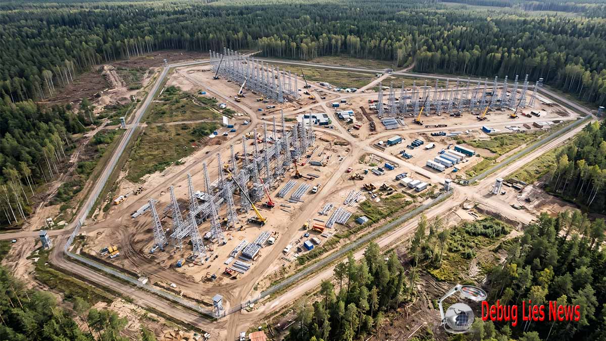
Notice: This image is a computer-generated 3D realistic visual reconstruction created and owned by debuglies.com © 2026. All rights reserved.
The visualization is based on satellite imagery (courtesy of ICEYE) captured in late August 2026 near Gvardeysk, in the Russian exclave of Kaliningrad. The original imagery reveals three massive antenna arrays at a military radar site currently under construction. According to defense reporting, the facility hosts a large Over-The-Horizon (OTH) radar designed to track air and maritime assets at ranges up to approximately 1,900 miles.
- Visual Concept & 3D Reconstruction: debuglies.com
- Primary Source Material / SAR Imagery: ICEYE
- Reference Report: Stars and Stripes / German media reports (Stars and Stripes Article)
- Usage Terms: Any unauthorized reproduction, redistribution, or commercial use without prior written permission or proper attribution to debuglies.com is strictly prohibited.
The official record identifies a broader Russian military infrastructure programme, but not a proven unified surveillance network
The presence of different categories of military infrastructure within the same exclave creates a strong reason to investigate their potential complementarity, but it is not evidence that they share an integrated operational architecture. Lithuania’s intelligence assessment names the Container radar programme, the Voronezh-DM missile-warning radar, the new arsenal and the logistics base in the same discussion of military infrastructure development. These installations have different primary functions. A long-range over-the-horizon radar is relevant to detection and surveillance of airborne activity beyond conventional line-of-sight constraints. A missile-attack warning radar is associated with a different warning mission and sensor architecture. An arsenal and a logistics base belong principally to military sustainment and storage. Their co-location in a strategically significant exclave can support the broader conclusion that Moscow continues to develop the region as a military operating environment, but the record does not specify operational interfaces, common communications protocols or shared command functions between these installations.
This distinction prevents a particularly consequential analytical error: describing infrastructure diversity as proof of network effectiveness. The strategic potential of combining different sensors is evident because observations from distinct collection methods can, under appropriate technical and organisational conditions, reduce ambiguity and improve the interpretation of military activity. Yet the quality of such a combined intelligence picture depends on compatibility, information management, timeliness and the ability to reconcile observations with differing accuracy and reliability. These are organisational and technical requirements that cannot be inferred from geographical proximity. The existence of a Container-related construction programme and an established missile-warning installation does not demonstrate that the two systems exchange operationally useful information, that their outputs are automatically fused, or that military commanders receive a consolidated view of the air environment.
The broader Russian electronic warfare activity reported by Lithuania introduces another relevant category of infrastructure and military behaviour. The March assessment states that Russian forces actively employ electronic warfare equipment in Karaliaučius to disrupt or falsify satellite-navigation signals. It identifies effects extending beyond the exclave, including adverse consequences for military and civilian aircraft, maritime navigation and other satellite-dependent systems operating in the Baltic region. It further attributes the principal Russian rationale to the protection of military installations and critical infrastructure against threats involving satellite-navigation-dependent unmanned systems and missiles. This is evidence of active Russian electromagnetic-spectrum operations, not evidence that the systems generating those effects are components of the Container radar network. The distinction is essential: electronic warfare, electronic intelligence and radar surveillance involve overlapping aspects of the electromagnetic environment but perform different missions and cannot be treated as interchangeable capabilities. National Threat Assessment 2026, section on Russian electronic warfare in Kaliningrad — AOTD and VSD — March 2026.
The October satellite reporting adds a further layer by referring to ICEYE-derived identification of more than twenty facilities associated with electronic intelligence and electronic warfare in the exclave. This information, also described in contemporary reporting by Stars and Stripes, suggests that the radar construction is occurring in a region with a wider and diverse collection and spectrum-operations infrastructure. However, the figure is a reported count of sites identified and classified in a satellite-imagery investigation, not an independently audited inventory of functioning Russian intelligence facilities. It would be inappropriate to interpret every reported site as operational, to assign each one a specific mission or to calculate the effectiveness of a hypothetical unified network from the aggregate count. The more defensible conclusion is that the regional infrastructure environment is sufficiently complex to warrant analysis of distinct systems and their possible interactions, while evidence of actual command-level integration remains incomplete. Russia Builds Powerful New Radar as Surveillance Contest with NATO Heats Up — Stars and Stripes — October 2026.
Evidence table: construction chronology, official assessments and the limits of confirmed knowledge
| Period or date | Documented development | Evidence authority | What can be established | What remains unresolved |
|---|---|---|---|---|
| Approximately March 2023 | Reported commencement of construction near Gvardeysk | Satellite-derived chronology published in October 2026 | A multiyear construction project is reported | Initial authorisation, contract award and approved completion date |
| 6 February 2026 | Information cut-off for Lithuanian National Threat Assessment | AOTD/VSD | Temporal limit of the official intelligence assessment | Developments occurring after that date |
| 6 March 2026 | Publication and presentation of National Threat Assessment 2026 | Lithuanian intelligence services and Ministry of National Defence | Official identification of 29B6 Container construction at several locations | Complete system configuration and commissioning |
| March 2026 assessment | Identification of Voronezh-DM, new arsenal and strategic-reserve logistics base | AOTD/VSD | Broader regional military infrastructure development | Operational interconnection with Container |
| Late August 2026 | Satellite imagery depicting three major antenna arrays, as reported subsequently | ICEYE-derived reporting | Visible substantial antenna construction | Exact equipment status and technical performance |
| 20 October 2026 | Polish specialist reporting on Gvardeysk radar construction | Defence24 | Public documentation of the major antenna structures | Independent technical identification of all components |
| 21 October 2026 | Publication of the Robert Lansing Institute analysis | Robert Lansing Institute | Reported dimensions, construction history, tentative system attribution and strategic interpretation | Precise architectural attribution, Chernyakhovsk function and readiness date |
| 26 October 2026 | Assessment cut-off | Synthesis of available records | Construction is documented; long-range surveillance is the intended function | Demonstrated operational capability and intelligence effectiveness |
The underlying official chronology is available in the National Threat Assessment 2026 — AOTD and VSD — March 2026 and the Lithuanian Ministry of National Defence presentation of the 2026 threat assessment — March 2026. The October observations are reported in Russia Is Building a Huge Radar Near the Border with Poland — Defence24 — October 2026 and Russia Expands Radar Surveillance of Europe — Robert Lansing Institute — October 2026.
The infrastructure programme belongs to a changing Baltic security environment, not simply to Russian territorial defence
The strategic setting in which the Container programme is developing has changed materially as NATO has strengthened its eastern-flank air-defence posture and expanded its Baltic-area surveillance arrangements. NATO’s official Air Defence information, updated on 8 October 2026, states that the Alliance has progressively upgraded its established Air Policing mission into a broader air-defence posture during 2026. The Alliance identifies the September 2025 launch of Eastern Sentry as part of the response to violations of Allied airspace by Russian drones and aircraft and explains that additional fighter aircraft, surveillance aircraft, refuelling and transport assets, and air-defence systems have been integrated into eastern-flank arrangements. This institutional development matters because a Russian long-range surveillance system operating from Karaliaučius would be introduced into an environment where Allied air activity encompasses not only local fighter patrols but also a wider combination of surveillance, reinforcement, support aviation and air-defence missions. NATO Air Defence — North Atlantic Treaty Organization — October 2026.
The relevance of these Allied activities to Russian strategic observation lies in their patterns over time. An individual aircraft movement may convey little about military intent, but repeated observations of the intensity, distribution and composition of Allied aviation could provide information about normal operating rhythms and changes in regional military posture. A long-range radar with reliable performance could potentially contribute to such assessments even when the observed activity occurs outside the immediate vicinity of the Russian exclave. This does not mean that Moscow would be able to identify the purpose of every aircraft movement or determine the intention behind an Allied exercise. It means that, under favourable conditions, additional long-range observations could improve the information available to Russian military analysts when comparing activity across successive periods. The military significance would arise from the relationship between observation and interpretation rather than from the observation alone.
The Baltic Sea’s strategic importance extends beyond its airspace. At the Baltic Sea NATO Allies Summit held in Helsinki on 14 January 2025, Denmark, Estonia, Finland, Germany, Latvia, Lithuania, Poland and Sweden issued a joint statement addressing serious incidents involving critical undersea infrastructure. The statement welcomed NATO’s Baltic Sentry enhanced vigilance activity and described efforts to coordinate maritime, airborne, land-based and subsea resources to improve situational awareness. It also referred to Commander Task Force-Baltic in Rostock and to the objective of establishing an integrated regional picture concerning critical infrastructure. These are official indications of the growing institutional importance assigned to surveillance and coordination in the Baltic environment. They do not establish that Russia’s Container radar is intended to monitor subsea infrastructure, which is outside the defined airborne-target surveillance function considered here. Their relevance is that the regional security environment increasingly depends on the quality, continuity and exchange of information across military and civilian domains. Joint Statement of the Baltic Sea NATO Allies Summit — Participating Allied Governments — January 2025.
These developments create a reciprocal intelligence problem. NATO seeks to maintain awareness of Russian military activity, airspace violations and potential threats to critical infrastructure, while Russia is pursuing infrastructure that could increase its observation of Allied activity. Neither side’s surveillance objectives establish the existence of an imminent offensive operation. The strategic consequence is nevertheless material: each increment in observation capability can affect how military movements are interpreted by the other side and how much confidence commanders place in their respective warning systems. A Russian radar installation capable of detecting broader air-activity patterns would not have to provide precise targeting data to become relevant to this interaction. It could acquire strategic value through its contribution to assessments of readiness, reinforcement and operational change.
The principal judgment from Chapter 1
The evidence establishes three linked but distinct propositions. Russia is continuing to develop fixed military infrastructure in Karaliaučius despite the temporary weakening of parts of its local ground-force component; Lithuanian intelligence identifies the construction of the 29B6 Container system as part of this development; and October 2026 satellite-derived reporting documents substantial antenna construction near Gvardeysk within a wider regional electromagnetic-surveillance environment. These propositions are sufficient to establish an important directional trend towards expanded Russian long-range observation capacity. They are not sufficient to establish a completed system, operational performance or an integrated Russian intelligence advantage.
The principal development that would change this assessment is credible confirmation of system commissioning and usable surveillance performance, followed by evidence that observations are exploited within Russian command processes. Until then, the appropriate analytical classification is substantial radar infrastructure development with a documented long-range surveillance purpose and unresolved operational maturity. The distinction protects against both exaggerating an unfinished system and overlooking the future significance of sustained construction investment.
Chapter 2. The 29B6 Container System: Propagation Principles, Detection Potential and Technical Limitations
Over-the-horizon radar changes the geographical logic of surveillance, but does not eliminate the constraints governing military detection
The technical significance of the 29B6 Container programme begins with the distinction between conventional radar coverage and the use of the ionosphere as a propagation medium. Conventional ground-based radar detection is constrained by the geometry of the Earth, the altitude of the target and the characteristics of the sensor. This does not imply a single universal detection horizon, because the relationship between an antenna and a target depends on their respective positions, atmospheric effects and operating conditions. It does mean that a conventional ground-based surveillance sensor cannot be assumed to observe every airborne object at arbitrarily large distances. Skywave over-the-horizon radar addresses this limitation through a different propagation mechanism. It transmits high-frequency electromagnetic signals that travel through the ionosphere, where they are refracted sufficiently to return towards the Earth’s surface. Signals scattered by targets can then provide observations from distances beyond the normal geometrical horizon. The relevant strategic development is not simply that detection distance increases, but that the potential observation area can become partially detached from the immediate geographical surroundings of the radar installation.
The 29B6 Container system is reported to exploit this method for long-range airborne-target detection. The Robert Lansing Institute’s October assessment associates the system with a nominal detection range of approximately 3,000 kilometres and refers to a possible surveillance sector extending to 240 degrees. These figures must be interpreted as reported characteristics of the radar type, not measurements established for the particular infrastructure near Gvardeysk. The article itself cautions that the antenna configuration requires additional technical identification and that the observed facilities have not all been conclusively attributed to one unified Container complex. Consequently, neither figure supports the construction of a verified European coverage map. A nominal radial distance does not identify the azimuth directions in which a completed radar can operate, the geographical regions in which propagation will be reliable, or the classes of targets that can be detected under particular conditions. The reported angular sector likewise cannot be assigned to the Gvardeysk installation without confirming its configuration and operating characteristics. Russia Expands Radar Surveillance of Europe — Robert Lansing Institute — October 2026.
The underlying scientific literature provides an important basis for understanding the difference between a theoretical surveillance envelope and an operationally useful detection capability. Research published in the American Geophysical Union journal Radio Science identifies skywave over-the-horizon radar as a technology that can support wide-area surveillance of aircraft and maritime vessels by exploiting high-frequency propagation through the ionosphere. The same research emphasises that the ionosphere is highly variable and that radar performance depends on a combination of the propagation environment, equipment characteristics, target properties, external noise, radio-frequency interference, signal processing and the allocation of radar resources. These are not incidental technical qualifications. They determine whether an airborne target situated within the nominal geographical reach of a system will generate a detectable, distinguishable and operationally useful observation at a particular moment. The scientific record therefore supports the general capability principle while preventing the nominal specifications associated with Container from being interpreted as continuous, uniform and verified European coverage. Climatological Model of Over-the-Horizon Radar — Cervera et al., Radio Science — 2018.
The first consequence of this propagation mechanism is that a facility situated in the Baltic exclave could, under suitable conditions, observe selected airborne activity at distances far beyond its immediate territorial surroundings. The second consequence is that the potential surveillance area would not necessarily behave like a uniform geometric circle around Gvardeysk. The existence of a reported maximum range establishes a possible outer limit under specified conditions, not a guarantee that all intervening areas are continuously observable. The third consequence is that information obtained through ionospheric propagation must be interpreted in light of the path taken by the signal and the uncertainties affecting the observed return. These distinctions directly shape the facility’s prospective intelligence role. The radar might contribute to early indications of activity at long range without possessing the positional precision or uninterrupted tracking continuity required for other military functions.
The ionosphere introduces a variable operating environment with direct consequences for warning reliability
The principal environmental condition governing skywave over-the-horizon radar is the behaviour of the ionosphere. This region of the upper atmosphere contains charged particles that influence radio-wave propagation, with properties that vary in response to solar radiation and other environmental processes. The result is that the paths available to high-frequency signals do not remain identical throughout the day, across seasons or under changing ionospheric conditions. This variability affects both the ability to illuminate a particular distant area and the interpretation of signals returned from it. A radar that performs adequately under one set of propagation conditions cannot automatically be assumed to provide equivalent observations under another.
This is particularly significant for any assessment of continuous military surveillance. The concept of persistent observation may refer to a system remaining available for extended periods, to repeated monitoring of selected areas, or to uninterrupted tracking of a particular target. These are materially different operational achievements. A high-frequency over-the-horizon radar may be designed for sustained surveillance operations while still experiencing changes in usable propagation paths, detection performance and geographical coverage. The scientific literature describes the necessity of selecting suitable operating parameters in response to ionospheric conditions, but no public evidence examined here establishes how the proposed Gvardeysk installation would manage these variations in operational service. It would therefore be inappropriate to attribute a specific availability rate, continuous tracking capability or validated all-weather performance to the system.
The significance of variable propagation is not confined to periods when reception becomes difficult. Changes in the ionosphere can influence the apparent characteristics of radar returns and complicate the association of successive observations with the same target. High-frequency transmissions may follow different propagation paths under different conditions, while the signals returned from distant activity can be affected by the surrounding electromagnetic environment. The analytical importance is that a radar observation is not a complete representation of the object that generated it. It is an electromagnetic measurement requiring interpretation. Greater geographical reach can therefore coexist with uncertainty regarding target position, identity and continuity of observation. The development of effective over-the-horizon surveillance depends on the ability to manage these uncertainties through technical processing and analytical validation rather than on antenna dimensions alone.
Research examining the architecture and signal processing of skywave over-the-horizon radar identifies several major challenges, including variation in ionospheric electron density, interference from other users of high-frequency spectrum, atmospheric and other background noise, strong unwanted returns from land and sea surfaces, and disturbances affecting the phase and frequency characteristics of radar echoes. The literature also identifies multipath propagation as a source of ambiguity: signals following different paths can complicate the interpretation of a target’s apparent position, while returns from different targets may overlap in ways that make discrimination more difficult. These findings provide an established technical explanation for why long-range surveillance systems require substantial processing capabilities and why their performance cannot be inferred from advertised detection distance. They do not establish that the Russian Container installation has successfully overcome these challenges or that any particular limitation is presently degrading its performance. Architecture and Signal Processing of Sky Wave Over-the-Horizon Radar — Guo et al., Radio Science — 2003.
These technical constraints have an important strategic implication. An additional sensor can increase the number of observations available to a military intelligence organisation without necessarily increasing the proportion of those observations that can be interpreted correctly. If returns are ambiguous, inconsistent or insufficiently corroborated, their operational value may be limited even when the sensor detects activity at considerable distance. Conversely, observations that provide only broad indications of activity can still be valuable when they are reliable enough to identify a significant departure from previously established patterns. This distinction explains why the most credible near-term assessment of an operational Container system concerns its potential contribution to strategic surveillance and early indication rather than an assumed capacity for precise, continuous tracking of individual Allied aircraft.
Detection range, surveillance coverage, target recognition and tracking continuity are different dimensions of performance
A technically rigorous assessment must distinguish four capabilities that are often incorrectly combined into a single measure of radar effectiveness: the ability to detect an object, the extent of the geographical area in which detection is possible, the capacity to characterise the detected activity, and the ability to maintain a reliable sequence of observations over time. Detection establishes that a received signal may be associated with an object or activity of interest. Coverage describes the geographical and environmental conditions under which such detection is possible. Characterisation concerns what can legitimately be inferred about the nature of the target. Tracking continuity concerns whether observations can be reliably associated across successive measurements. None of these capabilities can be reduced to the maximum nominal range of the radar.
This is especially relevant to the reported figure of approximately 3,000 kilometres. In public discussion, such a figure may create the impression of a uniform surveillance umbrella extending across a large portion of Europe. The actual technical proposition is narrower. A radar type may be associated with detection of selected targets at such distances under suitable conditions. Whether the installation under construction will achieve that performance depends on its eventual configuration and operating environment. Whether it will maintain useful coverage over a particular country depends additionally on geographical orientation, propagation and target characteristics. Whether the resulting information can support military planning depends on the quality and continuity of observations. The number is consequently useful in identifying the intended scale of the system’s mission, but insufficient to establish the actual extent or reliability of Russian knowledge about Allied aviation.
A related distinction concerns airborne-target detection and the ability to determine the target’s operational identity. Information indicating that airborne activity is present at long distance may be useful for assessing the existence or scale of military movement. It does not necessarily establish the aircraft type, nationality, mission, payload or intention. Different categories of airborne activity can produce observations that remain ambiguous without additional information. This is not a reason to dismiss the intelligence value of over-the-horizon radar; it is a reason to identify accurately the level at which its information becomes useful. A broad but credible indication of unusual aviation activity could contribute to strategic warning, while a claim that the same indication establishes the preparation of a particular military operation would require substantially stronger corroboration.
The distinction between surveillance and fire control is equally important. Long-range detection of airborne activity does not mean that the radar can independently provide the precise, current and sufficiently reliable data necessary to guide a weapon against an individual aircraft. The Robert Lansing Institute explicitly recognises this limitation in its assessment, separating the potential wide-area surveillance role of the reported system from the functions of precision fire-control radar. The possible military contribution is therefore primarily informational, although information can indirectly support other military activities when combined with separate sensors and command capabilities. Describing the installation as a system that would allow Russia to strike aircraft anywhere within the reported maximum range would exceed the evidence and confuse fundamentally different stages of the military surveillance and engagement process. Russia Expands Radar Surveillance of Europe — Robert Lansing Institute — October 2026.
Technical assessment table: the difference between the reported system characteristic and operational evidence
| Technical dimension | Established principle or reported value | Relevant operational condition | What the current record supports | Unsupported conclusion to exclude |
|---|---|---|---|---|
| Radar type | 29B6 Container, associated with skywave over-the-horizon radar | Confirmation of configuration and functional components | Lithuanian intelligence identifies the programme | Every satellite-observed structure has been definitively identified as part of a single completed Container system |
| Propagation method | High-frequency signals exploiting ionospheric refraction | Suitable ionospheric propagation paths | Established physical principle of skywave OTHR | Uniform coverage at all times |
| Nominal detection range | Up to approximately 3,000 km | Target characteristics, propagation and usable radar performance | Reported capability characteristic | Confirmed 3,000 km performance at Gvardeysk |
| Reported angular sector | Up to 240 degrees | Confirmed antenna configuration and operating geometry | Specification associated with the radar type in October reporting | Validated coverage orientation of the construction site |
| Surveillance continuity | Intended long-range observation | Stable or effectively managed propagation and reliable processing | Potential for sustained surveillance operations | Continuous detection of all relevant aircraft |
| Target discrimination | Ability to distinguish relevant activity from unwanted signals | Sufficient signal quality and processing | Technical requirement identified in scientific literature | Verified classification of particular Allied aircraft |
| Tracking continuity | Repeated observations associated with targets | Reliable correlation across successive measurements | Potential functionality dependent on actual performance | Persistent, precise individual-target tracking |
| Noise and interference | Known constraints in high-frequency radar | Electromagnetic environment and interference management | Established category of performance limitation | Quantified degradation of the Russian installation |
| Ground and sea clutter | Unwanted returns requiring interpretation | Signal environment and processing effectiveness | Established scientific limitation | Complete elimination of unwanted returns |
| Operational availability | No confirmed commissioning date | Testing, acceptance, staffing and reliable service | Infrastructure remains under development in available reporting | A completed and fully available operational system |
| Contribution to warning | Potential additional long-range indications | Detection reliability and timely interpretation | Supported analytical possibility | Demonstrated reduction in Russian warning times |
| Contribution to weapons employment | Possible indirect intelligence support | Independent targeting-quality information and operational integration | No demonstrated direct fire-control function | Capability to guide weapons against aircraft solely from long-range detection |
Technical principles are supported by Climatological Model of Over-the-Horizon Radar — Radio Science — 2018 and Architecture and Signal Processing of Sky Wave Over-the-Horizon Radar — Radio Science — 2003. The reported Container specifications and site-specific uncertainty are documented in Russia Expands Radar Surveillance of Europe — Robert Lansing Institute — October 2026.
Detection potential becomes strategically valuable when repeated observations reveal changes in military activity
The military value of an over-the-horizon radar cannot be assessed solely through the individual target detections it might generate. Its broader potential concerns the accumulation of observations over time and the establishment of patterns against which later activity can be compared. This is an important distinction because military readiness, reinforcement and operational preparation are not always represented by a single distinctive event. They may become apparent through changes in the intensity, distribution, timing or composition of activity. A sensor capable of observing selected distant air movements over repeated periods could contribute evidence relevant to these assessments, provided its own detection variations are sufficiently understood to distinguish changes in actual activity from changes in measurement conditions.
Such pattern analysis would require an intelligence organisation to interpret the radar’s observations in context. Increased airborne activity might reflect a training exercise, routine force rotation, precautionary deployment, air-defence response or broader military preparation. A change in observed aviation patterns is therefore an indicator requiring explanation, not proof of hostile intent. The principal benefit of additional surveillance information would be the possibility of identifying a development that deserves closer assessment, improving the timing of intelligence attention and comparing it with independently obtained information. Even when the sensor cannot establish the identity or purpose of every detected aircraft, it might still contribute to an assessment of whether overall activity is consistent with previously observed conditions.
The importance of this distinction increases in a crisis. Military authorities operating under uncertainty can attach disproportionate significance to incomplete indications of adversary activity. An additional source of long-range observation could improve the information available to commanders, but it could also introduce ambiguous signals requiring careful interpretation. The strategic outcome therefore depends on the quality of the intelligence process. Effective corroboration may reduce uncertainty; premature interpretation may convert observational anomalies into erroneous conclusions about intent. The existence of a sensor does not predetermine which outcome will prevail.
This issue is directly relevant to NATO aviation activity across Northern and Central Europe. NATO’s October 2026 Air Defence documentation describes a posture involving fighter aviation, surveillance aircraft, refuelling assets and other capabilities operating within a wider integrated air-defence framework. The composition of this activity is important because not all observable aircraft perform the same function. A radar indication of increased airborne movements, even if reliable, would not necessarily distinguish a routine multinational exercise from preparations for an operational contingency. The greater intelligence value would arise when observations are considered alongside established schedules, other surveillance information and changes in the broader military environment. NATO Air Defence — NATO — October 2026.
The strategic implications are therefore best understood as an expansion of potential collection opportunities rather than an automatic increase in Russian knowledge. The Container programme could add a geographically extensive source of airborne-activity indications, but the information advantage would depend on the ability to interpret those indications correctly and consistently. The actual intelligence contribution might be substantial for observing broad changes in aviation activity while remaining limited for other tasks requiring precise target identification. This differentiated outcome is more consistent with the technical record than an assessment treating the radar as either militarily transformative in every respect or strategically irrelevant because it cannot perform precision fire control.
Why a new radar does not necessarily produce a proportional increase in intelligence effectiveness
The value of adding a sensor to an existing surveillance environment depends in part on whether it provides information that is genuinely new. If the new system repeatedly observes activity already detected and adequately characterised by existing intelligence sources, its principal contribution may be corroboration, redundancy or greater confidence rather than a substantial expansion of knowledge. If it provides observations from previously unavailable distances or conditions, it could expand the breadth of intelligence collection. If its information arrives earlier than comparable indications from other sources, the potential contribution to warning could be more significant. Each of these outcomes requires different evidence and should not be represented by a single assertion that surveillance range has increased.
This distinction also introduces the problem of correlation. Two sensors observing the same event do not automatically provide two independent confirmations if their interpretations depend on common assumptions or shared information. Equally, multiple observations of activity may not improve accuracy if they cannot be associated with the correct target or geographical context. The analytical objective is not merely to accumulate more detections but to improve the reliability of conclusions drawn from them. A radar installation with impressive physical dimensions could contribute comparatively little additional information if its observations are redundant or difficult to interpret. A smaller increment in coverage could have greater strategic significance if it fills a consequential information gap. There is no evidence in the public record sufficient to determine which outcome the completed Karaliaučius complex would produce relative to Russia’s existing intelligence capabilities.
The operational consequences must therefore be evaluated through three separate questions. The first is whether the radar provides reliable observations of military activity that Russian authorities could not previously observe as effectively. The second is whether those observations improve the accuracy or timeliness of assessments when combined with other information. The third is whether the improvement is sufficiently consequential to influence military decisions. The difference between the first and third questions is substantial. An increase in technical detection capacity may be real without meaningfully changing an intelligence organisation’s assessments. Conversely, a limited but well-timed warning indication could be valuable if it resolves an uncertainty affecting a major decision.
These questions become especially important when evaluating claims that new surveillance infrastructure could compress Russian military decision timelines. A radar might provide earlier information, but the effect on decision timing would depend on how long the information requires for validation, transmission, interpretation and command consideration. There is no verified baseline in the reviewed evidence for the time Russian authorities currently require to recognise relevant Allied activity, and no documented measurement of the improvement the Container installation might produce. Assigning a numerical reduction in warning time would therefore manufacture precision. The defensible proposition is qualitative: additional reliable observation could reduce the interval between an external development and Russian awareness of it, if the observation is sufficiently timely and integrated into functioning decision processes.
The principal judgment from Chapter 2
The 29B6 Container programme is technically significant because skywave over-the-horizon radar can extend the geographical possibilities of airborne surveillance beyond conventional line-of-sight constraints. Its potential strategic contribution is the generation of long-distance indications relevant to the interpretation of military activity, rather than the independent provision of precision engagement information. The reported maximum detection distance of approximately 3,000 kilometres identifies the intended scale of the system’s surveillance role but cannot establish the coverage, performance or reliability of the facility under construction.
The scientific record demonstrates why the gap between nominal capability and operational effect is substantial. Ionospheric variability, interference, clutter, target characteristics and signal-processing demands determine whether observations are usable, while military intelligence procedures determine whether they become reliable warning. The available evidence therefore supports an assessment of significant potential without establishing demonstrated effectiveness.
What would materially change the judgment is not another statement of nominal range but credible evidence of operational performance over time, including the reliability of distant detection, the quality of target discrimination and the ability to exploit observations under varying conditions. Those developments would establish whether Russia has moved beyond constructing an extensive radar infrastructure towards obtaining a dependable new source of strategic intelligence.
Chapter 3. Gvardeysk, Chernyakhovsk and the Geography of Russia’s Baltic Intelligence Infrastructure
Karaliaučius gives Russia a forward geographical position, but geography alone does not establish surveillance superiority
The geographical significance of the infrastructure reported near Gvardeysk is inseparable from the unusual military position of the Karaliaučius exclave. Situated between Poland and Lithuania and adjoining the Baltic Sea, the territory places Russian military installations close to NATO member states while remaining physically separated from Russia’s principal contiguous territory. This location creates an important strategic contrast. From an operational-support perspective, geographical separation creates requirements for sustaining and protecting military infrastructure. From an intelligence perspective, the same territory provides a forward position from which Russian sensors may observe activity relevant to the Alliance’s eastern and northern European military environment. The importance of an over-the-horizon radar installation within this geography derives from the potential combination of forward location and long-range propagation. A system intended to detect selected airborne targets at continental distances could make the exclave relevant to Russian intelligence assessments extending considerably beyond the Polish and Lithuanian border regions.
The reported construction site near Gvardeysk, approximately 37 kilometres from the Polish border according to the October 2026 reporting, illustrates why the location has attracted strategic attention. The figure establishes proximity to NATO territory, but it should not be confused with the system’s operational reach or with the geographical direction in which the radar is designed to observe. A site can be physically close to an international border while its principal surveillance function concerns much more distant airspace. Equally, its proximity does not establish that it can observe every aircraft operating immediately across that border. For a skywave over-the-horizon radar, geographical coverage depends on operating geometry and propagation conditions as well as geographical location. The fundamental analytical question is therefore not how close the installation is to Poland, but which distant areas it is eventually able to observe reliably and whether those observations supply information that Russian intelligence authorities could not previously acquire with comparable timeliness. Russia Expands Radar Surveillance of Europe — Robert Lansing Institute — October 2026.
This relationship between physical proximity and long-range observation is crucial to understanding the exclave’s potential transformation into a regional surveillance node. Conventional discussion of Karaliaučius frequently concentrates on military forces stationed inside the territory and the implications of their presence for neighbouring states. The radar programme requires an additional analytical perspective: military infrastructure can influence the regional balance through information collection without involving an immediate movement of forces. If the Container facility eventually becomes operational and performs as intended, its contribution could extend to understanding the patterns of Allied aviation activity associated with reinforcement, surveillance and air-defence operations across a substantially larger area. In that sense, a facility located within the Baltic region could acquire relevance to operational developments elsewhere in Europe, even when no direct military confrontation is taking place near the exclave itself.
There is nevertheless an important geographical limitation to any attempt to portray this prospective capability. A nominal detection distance cannot be converted into a map of actual coverage without validated information concerning antenna orientation, operating sectors, propagation and target performance. Although the Robert Lansing Institute cites a surveillance sector of up to 240 degrees in discussing reported Container characteristics, it also recognises uncertainty concerning the configuration of the antennas under construction. A sector expressed in degrees identifies an angular characteristic in a general specification; it does not establish the orientation of a particular installation or the quality of its performance throughout that sector. Consequently, assertions that the facility already observes the entirety of Germany, France, the United Kingdom or other named countries would exceed the evidence. The more defensible geographical judgment is that the system is intended to provide long-range surveillance of European airborne activity and could, subject to verified configuration and performance, acquire relevance to a wide geographical area.
Gvardeysk: the distinction between observed construction geometry and established radar architecture
The satellite-based descriptions of the Gvardeysk complex provide unusually concrete physical information for an emerging military surveillance installation. Three extensive antenna arrays have been reported, each exceeding 500 metres in length, arranged in a configuration described as star-shaped. These observations indicate a substantial construction footprint and suggest that the installation cannot be adequately understood as a minor local radar upgrade. The scale of the reported structures is relevant because long-range radar systems can require extensive antenna infrastructure, but the dimensions alone cannot identify the precise system architecture. The configuration must be interpreted through the technical characteristics of its constituent structures and their relationship to associated facilities, rather than through visual similarity to known radar designs. Russia Is Building a Huge Radar Near the Border with Poland — Defence24 — October 2026.
The principal challenge in interpreting the Gvardeysk reporting concerns the relationship between physical observation and functional identification. Satellite imagery may establish that extensive linear structures are present and may support measurements of their length and relative position. It cannot, without appropriate corroboration, establish every element of the electronic systems associated with them. Radar installations depend on more than visible antenna structures. Their operational performance requires associated equipment, processing arrangements and support infrastructure, but the present record does not provide verified details of these components for Gvardeysk. It would be inappropriate to reconstruct transmitter locations, receiver layouts, underground infrastructure or communications connections from the limited descriptive evidence available in public reporting. Such reconstruction would replace documented observation with engineering speculation.
The three-array description also creates a particular evidentiary requirement. The fact that several extensive structures have been reported does not establish that each performs the same function, that each operates independently or that all are simultaneously necessary for the facility’s intended surveillance mission. Their relative orientation could be relevant to understanding eventual coverage, but the reviewed evidence does not provide sufficient technical information to associate particular structures with particular surveillance sectors. The same limitation applies to attempts to interpret the configuration as proof of simultaneous multidirectional coverage. The observation of a star-shaped arrangement is a description of apparent physical geometry, not a validated operational diagram.
This distinction between configuration and function has direct implications for an intelligence assessment intended for senior decision-makers. Physical dimensions can support a finding that extensive infrastructure is being constructed. Technical identification requires additional evidence linking the observed structures to the characteristics of the intended radar system. Operational assessment requires further evidence demonstrating that the relevant components function together under realistic conditions. The progression between these categories is not automatic. An installation may possess the physical components of an intended architecture without having completed testing or achieving reliable performance. In the case of Gvardeysk, the official Lithuanian assessment strengthens the argument that the region contains an active Container programme, but the precise correspondence between all observed structures and the programme’s final technical architecture remains an open question.
Chernyakhovsk: why an unresolved construction feature must remain analytically separate
The circular feature reported near Chernyakhovsk creates a distinct problem of attribution. The Robert Lansing Institute’s October assessment describes a structure exceeding 1.6 kilometres in diameter but does not establish its function. Its size makes it a relevant subject for further examination because extensive construction within a militarily significant Russian territory may have implications for regional infrastructure development. Size alone, however, does not establish that the feature is a radar installation, an antenna structure or part of the 29B6 Container programme. The appropriate analytical approach is to retain the observation as a separately reported physical feature while withholding conclusions about its technical purpose until independent evidence becomes available. Russia Expands Radar Surveillance of Europe — Robert Lansing Institute — October 2026.
The distinction is important because an erroneous attribution could substantially distort the assessment of Russian surveillance capacity. Treating the Chernyakhovsk feature as an additional radar component could lead to unsupported assumptions concerning coverage, redundancy and the number of operational installations. Treating it as part of the same radar complex could also create the impression of a technically integrated network where the public evidence establishes only the existence of geographically separate structures. Conversely, excluding the feature from further analysis would overlook a potentially relevant observation. The appropriate position lies between these errors: the feature should remain within the regional infrastructure evidence record, but its contribution to the Container programme should not be asserted.
A more conclusive technical identification would require information that establishes both physical characteristics and functional relationships. In principle, evidence from repeated observations could help distinguish construction development from static features, while authoritative technical information could connect a particular structure to a known installation type. Any conclusion concerning integration would require a further evidentiary basis. Without such information, the record supports only a limited statement: a substantial circular feature has been reported near Chernyakhovsk, its function is unresolved, and no verified basis currently establishes its operational relationship to the radar construction near Gvardeysk.
This geographical separation is analytically relevant because the Lithuanian intelligence services describe elements of the Container programme under construction at several locations. The official statement makes a geographically distributed programme plausible, but it does not identify the Chernyakhovsk circular feature as a constituent part. The relationship between the official reference to multiple construction locations and the separate satellite observations must therefore remain a question for verification rather than an inferred technical conclusion.
Geographical evidence matrix: locations, functions and limits of attribution
| Site or geographical element | Documented or reported information | Military significance | Evidence status | Unresolved issue |
|---|---|---|---|---|
| Karaliaučius exclave | Russian territory adjoining Poland, Lithuania and the Baltic Sea | Forward geographical position for Russian military infrastructure | Established geographical context | Actual contribution of individual installations to integrated surveillance |
| Gvardeysk area | Major construction complex approximately 37 km from Polish border | Potential principal long-range surveillance installation | Satellite-derived reporting, October 2026 | Exact technical configuration and operational readiness |
| Gvardeysk antenna structures | Three arrays reportedly exceeding 500 m each | Substantial physical foundation for possible radar capability | Reported imagery observations | Function and operating relationship of each structure |
| Chernyakhovsk area | Separate circular feature reportedly exceeding 1.6 km in diameter | Potentially relevant regional infrastructure | Reported observation | Function, system attribution and operational significance |
| Other Container construction locations | Elements under construction at several locations in the exclave | Geographically distributed programme | Official Lithuanian intelligence assessment | Complete site inventory and technical relationships |
| Voronezh-DM installation | Missile-attack early-warning radar identified in the exclave | Distinct strategic warning function | Official Lithuanian intelligence assessment | Any operational data relationship with Container |
| Regional electronic warfare infrastructure | Active Russian satellite-signal disruption and falsification | Electromagnetic-spectrum operations affecting the Baltic environment | Official Lithuanian intelligence assessment | Relationship, if any, with Container surveillance |
| Additional electronic intelligence and warfare sites | More than twenty sites reportedly identified through ICEYE-derived analysis | Possible wider collection and spectrum-operations environment | Secondary reporting of satellite investigation | Individual functions, operational status and network integration |
| Baltic Sea air and maritime environment | NATO air-defence activities and multinational Baltic vigilance arrangements | Shared military operating environment with increasing surveillance requirements | NATO and Allied official records | Specific information advantages attributable to the new Russian radar |
The location-specific construction reporting is available in Russia Expands Radar Surveillance of Europe — Robert Lansing Institute — October 2026 and Russia Is Building a Huge Radar Near the Border with Poland — Defence24 — October 2026. The official assessment of military infrastructure and electronic warfare is contained in the National Threat Assessment 2026 — AOTD and VSD — March 2026.
The Baltic military geography has changed as NATO’s northern and eastern structures have become more integrated
The potential significance of the Russian radar programme must also be understood in relation to the transformation of NATO’s Baltic military geography. Finland joined NATO in April 2023 and Sweden in March 2024, bringing additional northern European territories into the Alliance’s collective-defence framework. This change altered the institutional and geographical setting of NATO planning around the Baltic Sea, although it did not automatically create a single unified operational system covering the entire region. The expansion of NATO membership increased the importance of coordinating military activity across northern and eastern Europe, while Russia’s continuing infrastructure development in Karaliaučius created an additional potential source of observation of that activity. The relevant consequence is that the Baltic area increasingly connects regional defence requirements with a wider European military geography. Strengthening NATO’s Eastern Flank — NATO.
Germany’s permanent military deployment programme in Lithuania provides a concrete example of the growing strategic importance of this regional connection. According to Lithuania’s Ministry of National Defence, the decision to permanently relocate a German brigade was taken in 2023, with the principal relocation phase occurring during 2025–2026 and full operational capability planned for 2027. The German Army’s 45th Armoured Brigade is intended to include three major combat units and associated support capabilities. Lithuania identifies an eventual personnel figure of approximately 5,000 soldiers and civilian personnel and around 2,000 military vehicles. The NATO Multinational Battlegroup Lithuania became part of the brigade in February 2026. These are official programme figures and milestones; they must not be treated as confirmation that the final force structure had already reached full operational readiness by October 2026. German Brigade in Lithuania — Lithuanian Ministry of National Defence.
The relevance of this deployment to the Container programme is not that a long-range radar would necessarily identify or track the brigade’s ground equipment. Rather, major multinational deployments increase the institutional importance of transportation, military mobility, air protection, reinforcement planning and supporting aviation activity. Where those processes involve aircraft, additional distant surveillance could potentially contribute indications relevant to Russian assessments of Allied readiness. Yet this remains a conditional intelligence relationship. The German brigade’s documented relocation does not demonstrate that Russian radar infrastructure has observed the associated activities, nor does it establish that Moscow possesses new information about the brigade’s operational readiness. The important point is that the broader regional security environment now involves military developments whose logistical and operational consequences can extend across multiple Allied states.
A similar distinction applies to NATO’s wider eastern-flank posture. NATO’s official documentation identifies Germany as the framework nation for the multinational presence in Lithuania, the United Kingdom for Estonia, and other Allied arrangements across the region. It also records the development of regional defence plans and measures intended to improve reinforcement, readiness and command coordination. These institutional changes create a more interconnected environment for Allied military activity, but they do not establish that Russian surveillance is capable of comprehensively observing the resulting network. The potential intelligence value of the Container programme would depend on whether its observations contribute useful information about aspects of these activities that are otherwise less visible to Russian authorities. Strengthening NATO’s Eastern Flank — NATO.
Regional military infrastructure must be assessed through relationships, not through an undifferentiated inventory of Russian assets
The principal methodological difficulty in interpreting the militarisation of Karaliaučius is the temptation to combine different military assets into an undifferentiated assertion of increasing Russian power. A radar installation, electronic warfare equipment, missile-warning infrastructure, logistics facilities and conventional military formations contribute to different functions. Their strategic effects depend on the missions they perform and the relationships between them. An assessment concerned with intelligence balance must therefore distinguish installations that generate information from those that act on information, those that sustain military operations and those that influence the electromagnetic operating environment.
The Container programme belongs primarily to the first category. Its prospective contribution is the detection of distant airborne activity. The Voronezh-DM installation belongs to the broader strategic warning infrastructure but has a distinct mission. Electronic warfare equipment can influence the availability or integrity of satellite-dependent services and thereby affect the operating environment of military and civilian users. Logistics facilities provide support to military operations rather than directly generating the surveillance picture. These distinctions do not exclude the possibility of interactions between systems. They establish why such interactions require proof before they can be incorporated into a claim of unified operational effectiveness.
For Russia, the strategic benefit of infrastructure diversity could arise from the coexistence of multiple means of gathering information and supporting military decisions. Such coexistence may provide different perspectives on military developments and reduce dependence on any one collection method. However, the extent to which this diversity translates into useful corroboration depends on technical and organisational relationships that have not been demonstrated in the available public record. Accordingly, the existence of several reported surveillance-related installations should increase analytical attention to possible integration, not automatically increase the assessed effectiveness of Russian command awareness.
This is particularly relevant to the more than twenty electronic intelligence and electronic warfare sites reportedly identified in the October satellite investigation. The figure suggests a potentially extensive regional electromagnetic infrastructure, but it does not establish the number of operational intelligence collectors, their individual coverage areas or the degree to which their information is shared. Moreover, electronic warfare activity intended to interfere with satellite signals cannot simply be classified as passive collection. It may affect navigation or communications, but that effect is not equivalent to observing a distant aircraft with radar. Treating every electromagnetic installation as part of a single surveillance network would therefore obscure rather than clarify Russia’s capabilities. Russia Builds Powerful New Radar as Surveillance Contest with NATO Heats Up — Stars and Stripes — October 2026.
The geographical position creates both intelligence opportunities and infrastructure dependencies
The value of Karaliaučius as a location for strategic surveillance should not be assessed without considering the practical requirements imposed by fixed infrastructure. Unlike a temporary deployment of aircraft or transportable military equipment, a large antenna installation is closely associated with its selected site. Its military utility depends on the continued operation of the physical equipment and the availability of supporting technical and organisational systems. This creates a dependency structure that is relevant to readiness even if no detailed information about the specific facility’s support arrangements is publicly available.
From the perspective of long-term military planning, fixed infrastructure can provide continuity. It allows repeated collection from a consistent geographical setting and can become part of an established intelligence process. That continuity may be valuable for comparing activity across time because observations collected by the same system can, if appropriately processed, contribute to a stable historical reference. From the perspective of operational resilience, however, dependence on a fixed facility means that technical availability, maintenance and communications remain important to the military value of the installation. The available sources provide no verified figures for the Gvardeysk project’s power requirements, maintenance demands, redundancy, repair capacity or overall availability. Consequently, these dependencies can be identified as relevant conditions without assigning a specific level of vulnerability.
The geographical position also affects how the installation should be interpreted during a crisis. A long-range surveillance facility within the exclave would be physically located in a region already central to Russian-NATO military concerns. Its information outputs, however, might concern activities elsewhere in Europe. This separation between the collection site and the subject of collection creates a wider relationship between regional security and strategic warning. Developments in distant airspace could become relevant to the information received by Russian authorities responsible for a sensitive geographical area, while events within the Baltic region could influence how that information is interpreted. The resulting effect is not necessarily increased escalation risk in every circumstance. Improved situational awareness could allow a military command to distinguish routine activity from more consequential developments. Equally, ambiguous observations could contribute to inaccurate assessments if they were interpreted without adequate corroboration. Both possibilities follow from the informational role of the radar and the inherent uncertainty of military intelligence.
The geographical significance of a future operational system will depend on demonstrated information access, not nominal territorial reach
A central question for European governments is whether a completed radar installation in Karaliaučius would provide Russia with information about Allied military activity that is presently unavailable or insufficiently timely. The answer cannot be derived from a geographical circle drawn around the reported installation. Such a circle would identify possible distances from a chosen point but would not establish the actual operating geometry of an ionospheric radar. Nor would it demonstrate target detection, identification or sustained tracking within that area.
The strategic significance of geography must instead be considered in terms of the military activities that might become observable and the decisions to which those observations could contribute. Northern European air-defence operations, multinational exercises, reinforcement aviation and support flights may generate patterns whose interpretation is relevant to the Baltic security environment. The existence of a Russian long-range radar capable of monitoring selected elements of that activity could improve Russian knowledge if its observations are sufficiently reliable and distinctive. Where activity is already well observed through other intelligence means, the improvement might consist principally of corroboration. Where the new system provides genuinely additional warning indications, its strategic contribution could be greater.
For Germany, the issue is particularly relevant because its military responsibilities in Lithuania connect national force preparation with Alliance operations on NATO’s eastern flank. For the United Kingdom and France, the relevance concerns the relationship between national air activity and wider NATO surveillance and reinforcement arrangements, while actual exposure to the reported radar remains unverified. For Italy, the principal question concerns the collective intelligence consequences of participating in Alliance defence arrangements whose associated aviation activity may cross different parts of Europe. These differences should not be erased by presenting Europe as a single homogeneous surveillance target. The geographic footprint, operational relevance and intelligence consequences of the radar would depend on distinct national and multinational military activities.
The European Union’s role must likewise be differentiated from NATO’s. NATO is the central military framework for air defence, collective military planning and the interpretation of hostile military developments affecting Allied territory. European Union institutions have important responsibilities in areas such as critical infrastructure, resilience and cooperation between member states, but those functions do not establish an EU command structure for NATO air-defence operations. The relevant relationship is therefore one of complementary security interests rather than institutional equivalence. The Baltic Sea summit’s January 2025 statement illustrates this distinction by addressing NATO’s enhanced vigilance activity alongside cooperation involving the European Commission and participating governments on critical infrastructure protection. Joint Statement of the Baltic Sea NATO Allies Summit — January 2025.
Principal assessment: what the geography of the emerging Russian surveillance system establishes
The reported infrastructure near Gvardeysk provides evidence of a significant long-range radar construction project within a geographically sensitive Russian territory adjoining NATO. The official Lithuanian intelligence assessment strengthens the interpretation that the project forms part of a broader programme of military infrastructure development involving elements of the 29B6 Container system at several locations. The separate Chernyakhovsk feature remains unresolved and cannot be incorporated into the established radar architecture without further evidence.
The strategic consequence of this geography is the possibility that Russia is developing a forward surveillance capability whose eventual observation area could extend substantially beyond the immediate Baltic region. That potential matters because NATO’s regional security environment now encompasses more extensive multinational military arrangements, including the development of a permanent German brigade in Lithuania, enhanced eastern-flank air-defence activities and additional coordination across the Baltic Sea. The prospective Russian radar could therefore become relevant to intelligence assessments concerning military activity in a broader European theatre.
What the geography does not establish is equally important. It does not establish actual operational coverage, reliable observation of specific countries, the function of every reported construction feature, the degree of integration between Russian installations or a completed intelligence advantage. Those questions require additional technical and operational evidence.
The most defensible conclusion is that Karaliaučius is acquiring the physical foundations of an expanded Russian long-range surveillance role, but the extent to which that role will change European military intelligence relationships remains dependent on technical readiness, sensor performance and information exploitation. The significance of the location is not that Russia would necessarily possess complete awareness of Allied aviation across Europe. It is that a geographically forward installation, if successfully developed and integrated, could provide an additional source of strategically relevant observations extending well beyond the immediate Baltic operating environment.
Pillar I — Consolidated Evidence Assessment and Transition to the Operational Intelligence Question
The three chapters establish a distinction that must remain central to the remainder of the dossier. There is a documented Russian programme of long-range radar construction in the Karaliaučius exclave, an official Lithuanian identification of the 29B6 Container system, and more recent satellite-derived reporting describing major antenna structures near Gvardeysk. There is also a scientifically established technical principle under which high-frequency over-the-horizon radar can provide observations beyond conventional line-of-sight constraints. The link between those propositions is strong enough to establish the strategic relevance of the developing infrastructure, but not sufficient to establish how effectively the installation will function when completed.
The decisive evidence can be classified at different levels without introducing unsupported quantitative confidence measures.
| Assessment proposition | Evidentiary standing | Decisive support | Strategic interpretation |
|---|---|---|---|
| Russia is expanding military infrastructure in Karaliaučius | Established by official intelligence assessment | Lithuanian AOTD/VSD, March 2026 | Sustained military investment independent of immediate ground-force readiness |
| Elements of the 29B6 Container system are under construction at several locations | Official intelligence assessment | Lithuanian National Threat Assessment 2026 | Identifies intended long-range surveillance function |
| Major antenna construction is visible near Gvardeysk | Reported satellite-derived observation | October 2026 ICEYE-based reporting | Supports substantial physical infrastructure development |
| Each of three reported antenna arrays exceeds 500 metres | Reported physical measurement | October 2026 satellite reporting | Establishes scale, not operational capability |
| The Container type is associated with detection at approximately 3,000 km | Reported technical characteristic | Robert Lansing Institute, October 2026 | Identifies potential long-range mission |
| Skywave radar performance depends on ionospheric and signal-processing conditions | Supported by published technical research | Radio Science, 2003 and 2018 | Limits inference from nominal specifications |
| The Chernyakhovsk circular feature belongs to the Container programme | Unresolved | October reporting does not establish function | Cannot be included as confirmed system component |
| The Gvardeysk installation is operational | Not established | No verified commissioning record in reviewed sources | Construction does not establish availability |
| The installation already improves Russian warning times | Not established | No validated performance or decision-timeline comparison | Remains a conditional prospective benefit |
| Russian surveillance facilities are integrated into a unified automated network | Not established | No verified public technical architecture | Network effectiveness cannot be inferred from site counts |
| The emerging programme is relevant to NATO’s future intelligence environment | Supported analytical judgment | Construction evidence, radar principle and documented NATO regional posture | Requires continued assessment of operational maturity |
The documentary foundation for these conclusions consists of the National Threat Assessment 2026 — Lithuanian Defence Intelligence and Security Service and State Security Department — March 2026, Russia Expands Radar Surveillance of Europe — Robert Lansing Institute — October 2026, Climatological Model of Over-the-Horizon Radar — Radio Science — 2018, and NATO Air Defence — NATO — October 2026.
The implications for intelligence policy now turn on a different question from those addressed in Pillar I. The physical infrastructure, reported configuration and technical limitations establish the potential sources of information. They do not determine how information would be processed, combined with other Russian intelligence sources, interpreted by military authorities or translated into earlier operational decisions. This distinction is critical because the strategic value of the radar will ultimately depend less on its individual characteristics than on its contribution to a functioning intelligence system.
A completed installation may provide additional observations without materially changing the intelligence balance if the information is unreliable, redundant or poorly integrated. Conversely, observations that are limited in precision could still have substantial value if they supply timely indications of changes in Allied aviation activity that Russian authorities would otherwise recognise later or less confidently. The assessment of this second possibility requires detailed consideration of information integration, the quality of the recognised air picture, operational warning arrangements and the relationship between Russian collection capabilities and NATO’s existing intelligence architecture.
For senior NATO and European decision-makers, the principal requirement is to avoid confusing the progressive visibility of Russian infrastructure with either guaranteed Russian operational superiority or negligible strategic importance. The infrastructure deserves sustained attention because it may eventually expand the information available to Russian military authorities. The claim of an altered intelligence balance, however, remains contingent on evidence that the installation produces reliable observations, that those observations provide useful information beyond existing collection capabilities, and that the resulting intelligence can influence military decisions.
The final judgment of Pillar I is that Russia is undertaking a significant and geographically consequential expansion of long-range surveillance infrastructure in Karaliaučius. The programme’s intended intelligence function is supported by official Lithuanian reporting and its physical development by more recent satellite observations. Its eventual operational effectiveness, network integration and effect on the NATO–Russia intelligence balance remain unresolved.
PILLAR II — INTELLIGENCE INTEGRATION AND THE OPERATIONAL BALANCE
Chapter 4. From Radar Detection to Strategic Warning: Intelligence Production and Operational Decision-Making
The decisive military advantage lies in converting information into warning before an adversary’s intentions become operationally evident
The strategic importance of Russia’s developing over-the-horizon radar capability in Karaliaučius cannot be determined by the geographical reach of the installation alone. The central operational question is whether information generated by a long-range radar can change what Russian military authorities know about NATO activity, when they know it and how confidently they can interpret it. These three dimensions of intelligence effectiveness are related but not interchangeable. Earlier detection does not necessarily produce earlier warning; an expanded volume of observations does not necessarily improve analytical accuracy; and improved situational awareness does not automatically produce faster or better military decisions. The significance of the proposed 29B6 Container capability therefore lies in a conditional chain of intelligence production through which distant electromagnetic observations could contribute to the recognition of military developments before they become apparent through other collection methods. The physical infrastructure examined in Pillar I establishes the potential addition of a collection source. Pillar II addresses the more consequential question of whether that source can be converted into usable information at the level of operational headquarters and strategic command.
The distinction has direct implications for evaluating the October 2026 assessment published by the Robert Lansing Institute. That assessment identifies the potential reduction of Russian detection and decision intervals as one of the principal strategic consequences of the reported radar programme. This interpretation is analytically plausible because additional long-range observations could give Russian authorities earlier indications of changes in Allied aviation patterns. However, the public evidence does not establish the current time required by Russian headquarters to recognise specific NATO activities, the expected reduction attributable to the new radar, or the processing arrangements through which its information would reach decision-makers. The report therefore supports a potential strategic mechanism rather than a demonstrated performance improvement. Its central warning should be interpreted as an assessment of what successful operational integration could achieve, not as confirmation that Russia has already obtained a measurable decision-time advantage. Russia Expands Radar Surveillance of Europe: How a New Station in Kaliningrad Is Changing Moscow’s Intelligence Capabilities — Robert Lansing Institute — October 2026.
The distinction between surveillance collection and intelligence production is explicitly recognised in NATO’s institutional doctrine. NATO describes intelligence as the product obtained when information from surveillance and reconnaissance is analysed and combined with material from other sources. Surveillance concerns the continuing observation of an area or object, whereas reconnaissance is directed towards answering a more specific information requirement. The Alliance’s Joint Intelligence, Surveillance and Reconnaissance framework consequently distinguishes collection assets, intelligence analysts and decision-makers as separate components of the information cycle. This provides an appropriate conceptual framework for assessing the prospective Russian capability without assuming access to classified Russian procedures. The existence of a sensor represents the collection stage; identifying an operational development requires analytical interpretation; issuing a warning requires sufficient confidence that the development is significant; and any subsequent military action depends on an authorised decision process. Joint Intelligence, Surveillance and Reconnaissance — North Atlantic Treaty Organization — July 2026.
For a command authority, the practical distinction becomes evident when an observation is relevant but ambiguous. A long-range radar may indicate increased airborne activity within a particular geographical area. That observation can be useful without establishing the nationality, mission or intentions of the aircraft concerned. An intelligence assessment would need to determine whether the activity represents a departure from established patterns, whether comparable information appears in other sources and whether there is sufficient contextual evidence to associate the development with an operationally significant change. The analytical stage is not merely administrative processing between detection and command action. It is the stage at which electromagnetic observations acquire or fail to acquire military meaning. The strategic advantage arises when the addition of the radar increases the reliability or timeliness of this interpretation, not when the radar simply generates more observations.
This distinction also limits the assumption that earlier detection necessarily means a reduction in military response time. If the information obtained is sufficiently reliable to establish a significant development, earlier detection may allow military authorities more time for consultation, contingency planning or precautionary action. If the information is ambiguous, additional verification may be necessary and the initial time advantage may diminish. If the radar generates observations already available through other sources, its principal contribution may be increased confidence rather than earlier awareness. These outcomes have different implications for military planning. A reduction in uncertainty may improve decision quality without changing the timing of a decision; earlier warning may extend the time available for deliberation without accelerating the decision itself; and faster interpretation may be undesirable if it produces premature confidence in an incorrect assessment. The strategic significance of information must therefore be evaluated through its effects on judgment as well as speed.
The warning cycle is governed by collection quality, interpretation and command responsiveness rather than detection distance
The transition from radar detection to strategic warning contains several distinct processes whose individual performance determines whether the system adds meaningful military value. An observation must first be produced under conditions that permit the radar to distinguish relevant airborne activity from background returns and interference. It must then be processed into a form that can be examined by analysts or associated with other information. The resulting observation may need to be compared with previously established patterns and independent collection sources. An intelligence organisation must determine whether the observation is sufficiently reliable and important to report. Finally, the assessment must be communicated to command authorities whose decisions may be influenced by the information.
The sequence is important because each stage introduces a different type of uncertainty. Technical uncertainty concerns the validity and characteristics of the radar return. Correlation uncertainty concerns whether different observations refer to the same activity. Analytical uncertainty concerns the interpretation of an observed pattern. Command uncertainty concerns the significance assigned to an assessment and the appropriateness of a response. These categories may overlap, but they are not identical. An observation can be technically accurate and strategically misleading if an exercise is interpreted as preparation for aggression. Conversely, an uncertain individual detection may contribute to a valuable warning judgment when consistent with other, independently obtained information.
The operational value of the proposed Container capability would therefore depend on how successfully Russian intelligence organisations manage these successive uncertainties. The public reporting does not identify the software architecture, personnel arrangements, communications procedures or command authorities responsible for exploiting data from the installation. It would be inappropriate to reconstruct those arrangements. Nevertheless, the general relationship between collection, analysis and decision is sufficiently established in intelligence practice to identify the conditions under which a new sensor becomes strategically consequential. The sensor must supply information that is both relevant to a military question and sufficiently reliable to influence the answer.
This is particularly relevant to the recognition of changes in aviation activity across Europe. A military intelligence organisation may be interested in whether the distribution of aircraft movements has altered, whether particular categories of support activity have become more prominent or whether several developments together indicate a change in readiness. A long-range radar could contribute observations relevant to these questions without independently resolving them. The essential comparison is between what the organisation could conclude before receiving the radar’s information and what it can conclude afterward. If the new information does not change the judgment, confidence or available warning interval, the operational improvement may be marginal. If the information resolves a previously consequential uncertainty, its strategic value may be substantial even without precise target identification.
The absence of a verified baseline is therefore a material limitation in the assessment. The public record examined here does not quantify the existing performance of Russian intelligence collection concerning NATO aviation, nor does it provide measured detection-to-assessment intervals for the proposed installation. There is consequently no defensible basis for calculating how many minutes or hours the Container programme might save Russian command authorities. Any quantitative warning-time claim would require operational evidence not presently available. The appropriate conclusion is that the system could improve the conditions for earlier warning if it supplies reliable and timely information that is not already available with equivalent quality.
Strategic warning must distinguish changes in military activity from evidence of hostile intent
A further constraint concerns the difference between observing a military activity and interpreting its purpose. Military movements are often visible long before the strategic intentions underlying them can be established with confidence. An increase in aviation activity may be associated with training, exercises, routine rotations, deterrence measures, precautionary deployments or preparations for more consequential military operations. The observation itself does not determine which explanation is correct. This is particularly important in a European security environment where NATO conducts continuing air-defence activities and reinforcement exercises, and where some changes in activity are deliberate responses to identifiable security concerns.
The possibility of observing more of these activities could improve Russian situational awareness by providing a more extensive record of Allied operational behaviour. Repeated observation may assist in recognising deviations from established patterns, while additional information from other sources may support the interpretation of those deviations. However, the relationship between a deviation and a military intention remains probabilistic in the ordinary analytical sense: several explanations may be consistent with the same observation. Without defensible prior probabilities and diagnostic evidence, numerical confidence estimates would be artificial. The intelligence problem is therefore one of disciplined interpretation rather than mechanical prediction.
A strategically important consequence follows. An effective warning system should not merely accelerate recognition of an unexpected event; it should help decision-makers understand what remains uncertain about the event. If a radar produces an indication of increased activity but the information cannot distinguish between several plausible explanations, the principal value may be to prompt additional collection and analysis. If other sources corroborate the activity and establish its operational context, the resulting assessment may justify greater confidence. The warning function is strongest when technical observation and contextual interpretation reinforce each other without collapsing uncertainty prematurely.
This distinction becomes particularly consequential during periods of acute political tension. Military authorities may interpret the same activity differently depending on the political situation, previous intelligence judgments and expectations concerning adversary behaviour. Additional radar information can improve awareness of observable events but cannot independently resolve the problem of intentions. It follows that the expansion of Russian long-range surveillance capacity could reduce some forms of uncertainty while leaving the most strategically sensitive judgments dependent on broader intelligence analysis.
Intelligence-production matrix: where additional radar information could change military decisions
| Intelligence function | Information potentially contributed by long-range radar | Additional evidence required | Potential military value | Current evidence concerning Gvardeysk |
|---|---|---|---|---|
| Initial activity indication | Detection of selected distant airborne activity | Confirmation that returns correspond to relevant activity | Wider geographical awareness | Potential function; not operationally demonstrated |
| Activity-pattern assessment | Repeated observations of changes over time | Reliable historical comparison and stable interpretation | Recognition of unusual military activity | No validated observation history available |
| Correlation with other collection | Radar indications compared with independent ISR information | Evidence of interoperability and shared processing | Reduced uncertainty and stronger assessments | Integration not established |
| Operational warning | Identification of activity relevant to military readiness or planning | Contextual interpretation and corroboration | Earlier consideration of possible operational developments | No demonstrated warning improvement |
| Strategic warning | Assessment of developments with wider military consequences | Multiple-source intelligence and political-military context | Greater time for consultation and contingency decisions | Conditional possibility |
| Air-picture development | Addition of distant observations to existing surveillance information | Reliable association, classification and processing | Broader recognised air picture | No verified Russian integration architecture |
| Command decision support | Timely communication of intelligence assessments | Functioning command procedures and authorised decision processes | More informed or potentially earlier decisions | No public performance measurement |
| Crisis stability | Better understanding of observed activity | Correct distinction between routine and threatening developments | Potential reduction in misinterpretation | Outcome depends on analytical quality |
| Warning failure risk | Ambiguous or inaccurate observations | Effective quality control and independent verification | Potential for delayed or mistaken decisions if unmanaged | Cannot be quantified from present evidence |
This assessment applies the documented distinction between surveillance, intelligence analysis and decision-making in Joint Intelligence, Surveillance and Reconnaissance — NATO — July 2026 to the prospective capability described in Russia Expands Radar Surveillance of Europe — Robert Lansing Institute — October 2026. The operational effects shown in the table are conditional analytical pathways, not reported Russian achievements.
The strategic consequence is a possible change in the quality of Russian anticipation, not an automatic change in combat power
The final distinction concerns the relationship between information advantage and military capability. A surveillance system may improve the ability of a military command to anticipate developments without changing the number of aircraft, missiles, ships or ground formations available to it. The information advantage may influence planning and readiness, but the capacity to act remains dependent on military resources, command authority and the operational circumstances. This is why a radar programme should not be described as independently altering the entire military balance. It may change one component of that balance: the relative ability to obtain and interpret information before decisions must be made.
The most consequential outcome would be an improvement in the quality of Russian anticipation. If the radar supplies observations unavailable through other collection methods, Russian analysts may be able to recognise changes in Allied activity with greater confidence or at an earlier stage. If those observations are properly integrated, the resulting information could contribute to a more coherent view of the European air environment. If the system is technically unreliable, analytically redundant or poorly exploited, the strategic effect could remain limited despite substantial infrastructure investment.
The principal judgment of Chapter 4 is therefore that the operational value of the reported Container programme must be assessed through the intelligence production cycle rather than through detection range. The development would become materially significant when reliable long-range observations demonstrably improve the timeliness, completeness or quality of Russian warning assessments. The public record does not yet establish that threshold, and it provides no credible basis for a quantified reduction in decision time.
Chapter 5. Sensor Fusion, Electronic Intelligence and Russian Command-and-Control Integration
Intelligence integration would determine whether the Container system becomes a regional sensor or a strategic information asset
The next question concerns the institutional and technical conditions under which Russia could exploit the information generated by an operational Container radar in conjunction with other surveillance systems. This is fundamentally different from assessing the performance of the radar itself. A technically capable sensor may contribute only limited intelligence if its observations cannot be correlated with independently collected information, distributed to relevant headquarters or incorporated into operational assessments. Conversely, a sensor whose observations are limited in detail may acquire substantial value when they resolve uncertainty left by other sources. The potential importance of the reported Karaliaučius installation therefore lies in its contribution to a wider information system, not in any assumption that a large over-the-horizon radar can independently deliver a complete and accurate picture of Allied aviation throughout Europe.
For Russian military authorities, the potential integration benefit would consist of combining different forms of observation that describe separate characteristics of an operational development. Long-range radar might contribute indications that airborne activity has appeared or changed over a wide geographical area. Other radar systems might provide observations obtained through different detection geometries. Electronic intelligence could, when relevant signals are present and successfully collected, contribute information concerning emissions associated with military activity. Additional intelligence sources might provide contextual information relevant to identifying the significance of those observations. The combination could strengthen the resulting assessment if the sources were sufficiently reliable and if their observations could be associated with the same events. No element of this relationship establishes that such integration is already occurring at the Gvardeysk facility. It describes the principal mechanism through which a new long-range sensor could become more valuable than its individual observations would suggest.
The distinction between complementary information and duplicated information is especially important. When different collection systems observe different characteristics of the same event, their outputs may reduce ambiguity. When they merely reproduce the same uncertain interpretation, adding further observations may create the appearance of stronger evidence without increasing its actual independence. Effective fusion must therefore account for both the reliability of individual observations and the relationships between their sources. The importance of this requirement increases when information moves from technical collection to strategic interpretation, because an erroneous correlation can generate a more convincing but still incorrect intelligence picture.
The NATO Joint Intelligence, Surveillance and Reconnaissance framework provides a public institutional illustration of why collection alone is insufficient. NATO identifies the collection, processing, exploitation, analysis and sharing of information as connected responsibilities requiring compatible technical systems and agreed organisational procedures. It also recognises that intelligence sharing among sovereign states can be constrained by classification, national procedures and technological compatibility. These observations concern NATO’s own system and cannot be transferred as evidence about Russian architecture. They do, however, establish that interoperability is an institutional and technical achievement rather than an automatic result of owning multiple sensors. Any assessment of the prospective Russian system must therefore distinguish potential sensor complementarity from verified operational fusion. Joint Intelligence, Surveillance and Reconnaissance — NATO — July 2026.
The contribution of electronic intelligence depends on the information it supplies, not merely on the presence of electromagnetic collection facilities
Electronic intelligence is particularly relevant to the integration question because it may provide information that differs in character from radar observations. Radar is an active sensing method when it illuminates targets with transmitted energy and receives resulting returns. Electronic intelligence generally concerns the collection and interpretation of electromagnetic emissions associated with other systems. The information available through these methods is not interchangeable. Radar may contribute evidence that airborne activity is present without identifying its purpose. Electronic emissions, where they can be detected and attributed, may provide additional contextual information relevant to the nature of the activity. The potential advantage arises when different observations can be interpreted together without assuming that one automatically validates the other.
The military significance of such complementarity is evident at a conceptual level, but its application to the reported Karaliaučius programme remains uncertain. Lithuania’s 2026 intelligence assessment identifies Russian electronic warfare activity in the exclave, particularly the disruption and falsification of satellite-navigation signals. These activities demonstrate an operational Russian presence in the electromagnetic domain and have consequences extending beyond military operations to civilian aviation and maritime navigation. They do not establish that the same equipment collects electronic intelligence or exchanges data with the Container programme. Electronic warfare and electronic intelligence must therefore remain separate analytical categories even when both involve radio-frequency systems. National Threat Assessment 2026 — Lithuanian Defence Intelligence and Security Service and State Security Department — March 2026.
A further distinction concerns the relationship between monitoring emissions and assessing the activity that produces them. Not all airborne activity generates the same observable signals, and the absence of a particular emission does not establish the absence of a military aircraft. Conversely, the presence of an emission does not necessarily identify the full mission or operational intentions associated with it. Consequently, combining radar and electronic intelligence may improve interpretation where genuinely complementary evidence exists, but the value of the combination depends on correct association, source reliability and the surrounding operational context. The present sources contain no verified evidence of how the reported Russian installation would perform that association.
The intelligence implications are therefore most defensibly expressed as a set of dependencies. Long-range radar must first produce usable observations. Other sources must provide sufficiently relevant and independently interpretable information. The collection system must permit those observations to be correlated. Analysts must distinguish genuine corroboration from common-source uncertainty. Command authorities must then receive an assessment whose confidence is justified by the underlying evidence. These conditions determine whether sensor diversity produces a more reliable intelligence picture or merely a more complex accumulation of information.
A recognised air picture is a constructed intelligence product rather than a direct representation of radar coverage
The term recognised air picture is important because it identifies a product created through the correlation and interpretation of observations, rather than a simple display of everything detected by one radar. At the operational level, a recognised air picture may support an understanding of airborne activity relevant to the responsibilities of a military command. Its quality depends on the accuracy, currency, consistency and completeness of the underlying information. The addition of a long-range sensor could expand the geographical scope from which indications are received, but that expansion would not necessarily improve every dimension of the picture.
An effective system must distinguish observations that describe the same activity from observations that describe different events. It must account for information arriving at different times and with different degrees of accuracy. It must also preserve uncertainty where the available evidence does not justify definitive classification. These functions are particularly relevant to a long-range sensor whose detection characteristics differ from those of other radar types. A broad indication of distant activity may be useful for awareness without providing the precision associated with a local surveillance sensor. The intelligence system must therefore avoid treating all observations as equivalent.
For Russian command authorities, the potential benefit would be a more comprehensive understanding of changes in airborne activity across the geographical areas that the completed Container system could actually observe. Where other sensors already provide detailed information, long-range observations might supply earlier indications or independent context. Where no comparable collection is available, the radar might provide an additional source of awareness. The relative value depends on the existing surveillance baseline, which is not documented in sufficient detail to permit a quantitative comparison.
The risk of false precision is considerable. It would be analytically incorrect to interpret the nominal geographical reach of the radar as the area within which Russia would possess a complete recognised air picture. A recognised air picture requires more than geographical detection; it requires reliable processing, correlation and interpretation. Similarly, the existence of additional Russian surveillance-related installations cannot establish that a unified air picture has been achieved. The evidence supports the possibility that the Container programme could contribute to such an information product, not the conclusion that the product already exists with defined geographical coverage and operational quality.
The distinction between surveillance integration and air-defence integration is operationally consequential
A further analytical distinction is required between using radar information to support military awareness and integrating that information into an air-defence system. These functions may be related, but they do not require the same level of information quality. A command authority concerned with strategic warning may benefit from broad indications of distant airborne activity. An air-defence organisation responsible for identifying and responding to immediate threats requires information appropriate to its particular decisions. The requirements for confidence, timeliness and target description may therefore differ substantially.
The prospective Container installation could contribute to air-defence awareness by supplying information about distant activity before it is observed by other sensors. Such information might support planning or alerting functions if relevant to an anticipated development. It does not follow that the over-the-horizon radar could independently provide the information required for weapon employment. The evidence does not establish direct integration with particular Russian air-defence systems, engagement networks or command procedures. Nor does it establish that the radar would provide a verified improvement in the effectiveness of Russian air-defence operations.
The distinction matters at the strategic level because discussions of sensor integration can otherwise obscure important capability boundaries. A system may be useful for identifying a general change in activity but insufficiently precise for supporting a specific operational response. A source may contribute to long-term pattern analysis while offering less value for immediate tactical decisions. A radar may increase geographical awareness without changing the ability of other systems to identify individual targets. Treating these outcomes as separate possibilities provides a more accurate basis for assessing the Russian programme than assigning it a single, undifferentiated level of military effectiveness.
The NATO Integrated Air and Missile Defence framework illustrates the distinction between interconnected sensors, command-and-control functions and weapons systems. NATO states that its integrated system, NATINAMDS, incorporates national and NATO capabilities under the authority of the Supreme Allied Commander Europe, with interoperability across technical, procedural and human dimensions. This is an established description of Allied arrangements, not evidence concerning Russian systems. Its relevance is that it demonstrates the institutional complexity involved in converting information from multiple sources into a coordinated air-defence capability. The existence of a new Russian sensor is therefore insufficient to establish an equivalent change in Russian air-defence effectiveness. NATO Integrated Air and Missile Defence — NATO — October 2026.
Integration matrix: potential value, conditions and evidentiary gaps
| Integration relationship | Potential information contribution | Conditions for useful integration | Principal limitation | Evidentiary standing |
|---|---|---|---|---|
| Container and other radar sources | Long-range indications combined with observations from different detection geometries | Consistent processing, timing and correlation | Different observation characteristics may complicate association | Technically plausible; no verified Karaliaučius connection |
| Container and electronic intelligence | Activity indications combined with relevant electromagnetic-emission information | Independently useful observations and correct attribution | Emissions do not necessarily establish target identity or intention | No documented operational data exchange |
| Container and imagery intelligence | Radar indications interpreted alongside imagery-derived contextual information | Compatible collection periods and reliable geographical association | Different collection methods answer different questions | Potential relationship only |
| Container and historical pattern analysis | Comparison of successive aviation observations | Consistent interpretation and sufficient historical information | Sensor variability can resemble changes in activity | No validated operational observation history |
| Container and regional air surveillance | Additional information relevant to broader regional awareness | Appropriate correlation and information distribution | Coverage does not equal comprehensive recognition | No demonstrated unified Russian air picture |
| Container and strategic warning | Possible early indications of significant changes | Analytical corroboration and clear reporting procedures | Intent remains uncertain even when activity is detected | Conditional analytical judgment |
| Container and military command | Timely assessments supplied to relevant authorities | Reliable communications and functioning decision processes | Information availability does not determine command decisions | No verified Russian command architecture |
| Container and air-defence planning | Greater contextual awareness of distant aviation developments | Information appropriate to the planning requirement | Broad detection does not establish precision engagement data | Potential indirect contribution |
| Container and operational resilience | Additional collection method within a broader surveillance environment | Independent availability and effective continuity arrangements | Additional infrastructure also creates support requirements | Redundancy benefits not demonstrated |
The institutional distinction between collection, exploitation and dissemination is documented in Joint Intelligence, Surveillance and Reconnaissance — NATO — July 2026, while the architecture of Allied integrated air defence is described in NATO Integrated Air and Missile Defence — NATO — October 2026. The Russian-specific integration relationships remain analytical possibilities rather than verified deployments.
The principal integration risk is mistaking greater information volume for greater command awareness
The expansion of surveillance infrastructure can create a misleading appearance of improving intelligence performance if the assessment concentrates on the number or geographical reach of sensors. Effective command awareness depends on whether observations can be reconciled into a reliable and timely account of relevant activity. More sensors can provide additional information, but they can also introduce conflicting observations, different standards of accuracy and greater analytical demands. A military intelligence organisation may therefore experience an increase in collection without achieving a corresponding improvement in understanding.
This distinction is particularly important where a new sensor provides geographically broad but comparatively ambiguous observations. Its value depends on the ability to place those observations within a wider intelligence context. If existing collection sources can establish the nature of the activity and the new radar contributes earlier indications, the combined result may support better warning. If the radar repeatedly generates observations that cannot be reconciled with other information, the benefit may be limited. Without documented operational testing and exploitation, neither outcome can be asserted for the Karaliaučius programme.
The principal judgment of Chapter 5 is that the most consequential potential development is the integration of reliable long-range observations into a wider Russian intelligence process, rather than the addition of another radar to an existing military inventory. Such integration could improve the breadth, continuity and interpretation of Russian situational awareness. The public evidence, however, does not demonstrate the technical or organisational connections necessary to conclude that this improvement has already occurred.
Chapter 6. NATO Aviation Patterns, Operational Exposure and the Changing Intelligence Balance
The military relevance of European aviation patterns has increased as NATO has expanded the scope of its eastern-flank air-defence arrangements
The prospective intelligence consequences of the Container programme must be examined against the actual structure of NATO aviation and surveillance activities rather than against an abstract category of Allied aircraft. NATO’s eastern-flank posture encompasses several functions that differ in their missions, operating requirements and contribution to collective defence. These include air-defence aircraft assigned to protect Allied airspace, airborne early-warning platforms, intelligence and surveillance aircraft, refuelling and transport assets, and aviation supporting multinational military activities. The significance of this diversity is that changes in the composition or distribution of aviation may convey information about different aspects of military activity. A broad increase in movements does not establish a particular purpose, but repeated and adequately interpreted observations could contribute to assessments of regional readiness, operational tempo and changes in force posture.
The institutional baseline is unusually well documented. NATO states that its air-policing arrangements began in 1961 and that Allied protection of Baltic airspace has operated since Estonia, Latvia and Lithuania joined the Alliance in 2004. During 2026, NATO integrated its traditional Air Policing mission with broader activities to establish a more comprehensive Air Defence posture. The transition followed the establishment of Eastern Sentry in September 2025, after Russian airspace violations involving drones and aircraft increased the importance of enhanced Allied vigilance. NATO’s 8 October 2026 Air Defence update identifies an arrangement that includes quick-reaction aircraft, maritime and land-based air-defence systems, counter-uncrewed-aircraft capabilities and additional supporting aviation. The consequence for the intelligence environment is that Allied activity in the Baltic theatre is no longer adequately understood solely through the rotations of fighter aircraft assigned to air-policing duties. It takes place within a broader framework of continuous defence, surveillance, reinforcement and operational coordination. NATO Air Defence — NATO — October 2026.
This change matters to Russian intelligence because the interpretation of Allied aviation depends on understanding what normal activity looks like within the evolving operational framework. A surveillance system that observes increased activity without understanding the baseline may misinterpret routine developments as exceptional. Conversely, a system that can compare observations over time and relate them to independently available information may be better placed to identify meaningful departures from established patterns. The proposed Container capability could contribute to this process if it becomes operational and provides reliable observations of relevant activities. Its value would lie in the additional information it makes available, not in an assumption that it could independently identify the missions or strategic intentions associated with every observed aircraft.
The transformation of NATO’s Baltic air posture also demonstrates why the intelligence balance is not a simple comparison between Russian detection range and Allied aircraft numbers. NATO operates a multinational air-defence structure supported by national capabilities and common command arrangements. Russia’s potential collection advantage must be evaluated relative to this existing architecture, its capacity to adapt and the extent to which any new Russian observations alter the information available to decision-makers. A long-range radar might increase Russian awareness of selected movements, but the effect on NATO’s overall military position depends on whether those observations become operationally useful and whether Allied arrangements remain capable of fulfilling their missions.
NATO’s existing airborne surveillance architecture provides a concrete basis for comparison, but not a symmetrical performance measurement
NATO’s Airborne Warning and Control System provides an important example of an operationally established surveillance and command capability. In its July 2026 institutional description, NATO identifies a fleet of 14 Boeing E-3A aircraft based at Geilenkirchen in Germany. These aircraft provide air surveillance, command and control, battlespace management and communications functions. NATO states that its AWACS force can detect, track, identify and report potentially hostile aircraft, including low-altitude activity, while also supporting the control of Allied fighter operations. The Alliance further reports that AWACS aircraft have conducted hundreds of missions along NATO’s eastern flank in recent years and have contributed to Eastern Sentry since September 2025. These facts establish an existing Allied capacity that combines airborne observation with operational command functions. They do not establish an exact equivalence between AWACS capabilities and the Russian Container system, which differ in sensor type, intended employment and publicly documented maturity. AWACS: NATO’s Eyes in the Sky — NATO — July 2026.
The distinction is consequential for comparative assessment. NATO AWACS is an airborne platform with documented surveillance and command functions, whereas the reported Russian system is a fixed long-range radar installation whose operational status remains unconfirmed. Their respective strengths cannot be evaluated by comparing a nominal maximum radar range with the number of aircraft in a fleet. Aircraft numbers do not establish how many platforms are mission-ready at a particular time, and nominal sensor range does not establish observation reliability or integration. Moreover, the two systems may provide information at different levels of geographical and operational detail. A defensible comparison must therefore focus on their contribution to military awareness rather than attempting to rank them through incompatible technical quantities.
NATO’s Intelligence, Surveillance and Reconnaissance Force provides a second concrete institutional comparison. According to NATO’s July 2026 documentation, the force operates five RQ-4D Phoenix remotely piloted aircraft from its main operating base at Sigonella in Italy. The aircraft employ synthetic-aperture radar and support surveillance and reconnaissance in cooperation with a multinational analytical organisation. NATO describes the force as an important component of its Joint ISR architecture and as a federated processing, exploitation and dissemination node receiving tasking from Supreme Headquarters Allied Powers Europe and Allied Air Command. Its function therefore includes the production and distribution of intelligence from both its own collection assets and information provided by Allied nations. This is important because it demonstrates that NATO’s intelligence posture includes substantial processing and analytical functions as well as airborne sensors. NATO Intelligence, Surveillance and Reconnaissance Force — NATO — July 2026.
The operational history of the force illustrates the geographical flexibility of an airborne surveillance organisation. On 12 June 2026, the NATO ISR Force reported that two of its five RQ-4D Phoenix aircraft were operating from Pirkkala Air Base in Finland in support of Exercise Ramstein Flag 2026. The deployment formed part of an Agile Combat Employment activity conducted away from the force’s principal operating base in Italy. The significance of this documented event is not that it proves a specific Russian capacity to observe the aircraft or reveals current Allied operational practices. It demonstrates, at the institutional level, that NATO can employ surveillance assets from different locations within its European operating environment while retaining their relationship with a wider intelligence organisation. This matters when assessing the comparative intelligence balance because geographical flexibility and information integration are distinct dimensions of operational capability. NISRF Agile Combat Employment Underpins Support to Ramstein Flag 2026 from Finland — NATO Intelligence, Surveillance and Reconnaissance Force — June 2026.
The Alliance has also announced a further expansion of its surveillance architecture. On 7 July 2026, Denmark, Finland, Germany and Norway announced procurement of up to five MQ-4C Triton aircraft to enhance NATO-owned ISR capabilities. NATO describes the aircraft as designed for maritime surveillance, capable of flights lasting approximately 24 hours at altitudes exceeding 15 kilometres, and intended to complement the existing RQ-4D fleet. The announcement also identifies Northrop Grumman as the aircraft manufacturer and Airbus Defence and Space and other European companies as participants in ground-segment, data-management, command-and-control, infrastructure and mission-support activities. This provides an important industrial and institutional indication of NATO’s efforts to strengthen surveillance, but the distinction between procurement announcement and operational delivery must be preserved. The prospective Triton aircraft cannot be counted as additional operational NATO surveillance aircraft on the basis of the July announcement alone. NATO Expands Its Intelligence, Surveillance and Reconnaissance Fleet with the Purchase of Triton Aircraft — NATO — July 2026.
NATO surveillance and intelligence capabilities: official quantitative baseline
| Capability or programme | Official quantitative information | Reference period | Principal documented role | Assessment limitation |
|---|---|---|---|---|
| NATO E-3A AWACS fleet | 14 aircraft | July 2026 | Air surveillance, command and control, battlespace management | Inventory is not equivalent to simultaneously available aircraft |
| NATO RQ-4D Phoenix fleet | 5 remotely piloted aircraft | July 2026 | Surveillance and reconnaissance within the NATO ISR Force | Fleet size does not establish continuous theatre coverage |
| RQ-4D deployment to Finland | 2 of 5 aircraft | June 2026 | Support for Ramstein Flag 2026 and Agile Combat Employment | Event-specific documented deployment |
| MQ-4C Triton procurement | Up to 5 aircraft | Announced July 2026 | Prospective maritime surveillance and early threat detection | Announcement, not completed delivery |
| MQ-4C reported endurance | Approximately 24-hour flights | July 2026 description | Long-duration surveillance mission design | Declared platform characteristic |
| MQ-4C operating altitude | More than 15 km | July 2026 description | High-altitude surveillance capability | Declared platform characteristic |
| Baltic Allied air presence | Continuous multinational mission since 2004 | NATO institutional history | Protection of Baltic Allied airspace | Historical continuity, not a measure of present aircraft numbers |
| Baltic Air Defence rotation | Four-month rotational model | October 2026 | Multinational aircraft deployments | Does not establish uniform force composition across rotations |
| NATO Air Policing origin | 1961 | NATO institutional history | Long-standing Allied airspace protection | Mission evolved substantially by 2026 |
| Eastern Sentry | Launched September 2025 | NATO institutional record | Enhanced vigilance and defence on eastern flank | Multidomain activity, not a single aircraft deployment |
| NATO Air Defence transition | Throughout 2026 | NATO institutional record | Integration of air policing with broader defensive functions | Transition does not independently quantify operational effectiveness |
Sources: AWACS: NATO’s Eyes in the Sky — NATO — July 2026, NATO Intelligence, Surveillance and Reconnaissance Force — NATO — July 2026, NATO Expands Its ISR Fleet with Triton Aircraft — NATO — July 2026, and NATO Air Defence — NATO — October 2026.
The balance of intelligence capabilities cannot be measured through platform counts or nominal radar specifications
These figures establish a concrete Allied institutional baseline, but they do not permit a numerical comparison of Russian and NATO intelligence effectiveness. NATO operates aircraft, fixed sensors, national collection capabilities, processing organisations and command networks whose roles differ from those of a single Russian over-the-horizon radar. The public sources identify some NATO-owned fleet sizes and particular deployment events, but they do not provide a comprehensive inventory of national and Alliance ISR capabilities or their simultaneous operational availability. On the Russian side, the public record does not establish the Container installation’s measured performance or the complete architecture into which it might be integrated. Consequently, neither a platform-count comparison nor a range-based ratio would produce a defensible assessment of relative intelligence advantage.
The more useful comparison concerns the different forms of information each system may provide. A fixed long-range radar potentially contributes geographically extensive airborne-activity indications. Airborne surveillance systems provide observations according to their particular missions and employment conditions. Intelligence fusion organisations combine information from multiple sources and distribute assessments to military authorities. These functions can complement each other within an integrated system, but their effectiveness depends on more than physical equipment. Command arrangements, access to information, technical interoperability and operational continuity are essential components of the comparison.
NATO’s Joint ISR framework explicitly addresses this institutional dimension through the principle that Allies should share relevant information while protecting sensitive data and collection methods. The Alliance recognises that national security restrictions, procedural requirements and technological differences can limit information sharing. These limitations matter because NATO is not a single national intelligence service. It is an Alliance whose collective awareness depends on cooperation between national and common capabilities. The Russian command system, by contrast, cannot be assessed as possessing automatically superior information integration merely because its assets belong to the same state. The public record contains insufficient evidence concerning the effectiveness of Russian data-sharing arrangements to support such a conclusion. Joint Intelligence, Surveillance and Reconnaissance — NATO — July 2026.
A particularly important consequence follows from the difference between geographical coverage and military knowledge. An intelligence organisation may possess wide-area observation capabilities without being able to explain the significance of every movement. Another organisation may have narrower or more intermittent observation of particular activities but stronger corroboration and contextual information. Neither can be declared categorically superior without assessing the questions each is attempting to answer and the evidence available to answer them. The Container programme could therefore alter particular aspects of the intelligence balance while leaving others largely unaffected. Its effect might be most significant for broad changes in aviation patterns and considerably less significant for questions requiring precise target identification or detailed understanding of military intent.
The prospective Russian advantage must be evaluated against NATO’s ability to sustain a coherent multinational intelligence picture
The question of relative advantage is further complicated by NATO’s capacity to operate and integrate surveillance systems across national territories. The NATO ISR Force’s principal base at Sigonella, its deployment of aircraft to Finland and its role in processing information from national sources demonstrate that Allied intelligence collection is not confined to a single geographical point. Similarly, NATO’s AWACS aircraft combine surveillance and command functions within a mobile airborne platform. These characteristics create a different operational model from that of a fixed radar installation in Karaliaučius. The comparison does not establish immunity from Russian observation; it establishes that NATO possesses multiple mechanisms for producing and integrating military information.
Germany occupies a particularly important institutional position in this architecture because NATO’s E-3A AWACS force is based at Geilenkirchen and Germany participates in both eastern-flank defence arrangements and the announced Triton procurement. Italy provides the principal operating base for the NATO ISR Force at Sigonella, which gives it a concrete connection to the Alliance’s intelligence infrastructure beyond its participation in air operations. Finland’s hosting of the June 2026 RQ-4D activity demonstrates a northern European operating role, while Denmark and Norway join Finland and Germany as participants in the announced procurement of additional surveillance aircraft. These are distinct institutional contributions and should not be conflated with the geographical areas potentially observable by Russian radar. NATO Intelligence, Surveillance and Reconnaissance Force — NATO — July 2026.
For France and the United Kingdom, the relevant comparative question is how national intelligence and aviation capabilities contribute to the common Alliance information environment. The evidence reviewed for this chapter does not establish a complete country-by-country inventory of their surveillance assets or a verified national exposure to the reported Gvardeysk radar. A quantitative national comparison would therefore be unsupported. The appropriate distinction is institutional: participation in common NATO air-defence and intelligence arrangements may make national activity relevant to the broader Alliance picture, while national authorities retain responsibilities for their own intelligence capabilities and decisions. An additional Russian long-range sensor might provide information about selected Allied activity, but the extent of national exposure cannot be established without verified coverage and operational-performance evidence.
The changing intelligence balance is multidimensional rather than a single contest for maximum surveillance range
The potential effect of the Container programme on NATO can be separated into several dimensions that may develop differently. Russia could gain wider detection opportunities without obtaining more precise information. It could improve the recognition of broad aviation patterns while continuing to face uncertainty about particular missions. It could obtain earlier indications without reducing the time required for command decisions. It could increase redundancy within its collection system without substantially improving the completeness of its intelligence. Each outcome would constitute a different degree and type of change in the intelligence balance.
A material improvement would require evidence that the new sensor alters the information available to Russian military authorities in a way relevant to their decisions. This might consist of broader awareness of activity at distances previously less effectively observed, more reliable identification of meaningful changes over time, or stronger corroboration of information obtained from other sources. The effect on NATO would then depend on the significance of the activity observed and on the operational circumstances. The same sensor could have limited relevance during routine conditions and greater relevance during a crisis in which distant aviation movements form part of wider military preparations.
The decisive comparison should therefore avoid claims of automatic superiority. NATO has an established surveillance and command architecture, and Russia is developing infrastructure that could add a new collection source. The public evidence does not demonstrate that the new source negates existing Allied capabilities or gives Moscow comprehensive knowledge of European aviation. It does justify attention to the possibility of a narrower but consequential change: improved Russian recognition of selected changes in Allied military activity.
Comparative intelligence-balance matrix
| Dimension of intelligence advantage | Existing documented NATO capability | Potential Russian Container contribution | Essential comparison | Present judgment |
|---|---|---|---|---|
| Wide-area surveillance | NATO airborne and national ISR assets | Additional long-distance airborne-activity observations | Useful coverage under real operating conditions | Russian potential identified; effect unmeasured |
| Airborne early warning | Operational NATO E-3A AWACS fleet | Possible earlier indication of selected distant activity | Reliability, timeliness and relevance of warning | No demonstrated comparative result |
| Intelligence fusion | NATO JISR and NISRF analytical arrangements | Possible incorporation into Russian multi-source assessments | Ability to correlate independent observations | Russian integration unresolved |
| Command support | NATO Air C2 and AWACS command functions | Possible additional information to Russian command authorities | Quality and timing of usable intelligence | No measured Russian improvement |
| Maritime ISR | Existing NATO assets and announced Triton expansion | Container’s primary reported role concerns airborne detection | Distinct mission functions | Not a direct like-for-like comparison |
| Operational flexibility | Deployable Allied aircraft and multinational collection | Fixed Russian radar infrastructure | Continuity, coverage and different operational roles | Comparative advantages cannot be ranked from current evidence |
| Aviation-pattern analysis | Multiple Allied collection sources and analytic organisations | Potential observation of selected European aviation patterns | Accuracy of baseline and recognition of changes | Conditional Russian benefit |
| Intelligence resilience | Allied national and multinational arrangements | Possible additional Russian collection diversity | Independence, continuity and redundancy | No quantified comparison |
| Strategic warning | NATO intelligence and air-defence organisations | Potential contribution to Russian warning processes | Whether new information changes decisions | Material effect remains unproven |
The official basis for the Allied side of this comparison is NATO Integrated Air and Missile Defence — NATO — October 2026, Joint Intelligence, Surveillance and Reconnaissance — NATO — July 2026, and AWACS: NATO’s Eyes in the Sky — NATO — July 2026.
The principal judgment of Chapter 6 is that the reported Russian radar expansion could alter specific dimensions of the NATO–Russia intelligence relationship, particularly the breadth and possible timeliness of Russian observations of Allied aviation, but no available evidence demonstrates a general transfer of intelligence superiority to Moscow. NATO possesses documented multinational surveillance, analytical and command capabilities, while the Russian installation’s operational effectiveness remains unresolved. The decisive future comparison will concern the information each side can reliably produce and exploit under relevant operational conditions, not the nominal technical reach or numerical inventory of individual platforms.
Chapter 7. The Baltic Crisis Environment: Information Advantage, Early Warning and Escalation Dynamics
A new long-range surveillance capability could influence crisis calculations before changing the military balance of forces
The final strategic question concerns the consequences of additional Russian long-range surveillance in a Baltic crisis, when the value of intelligence is determined not only by the accuracy of observations but also by the decisions that must be made under political and military uncertainty. In such circumstances, a new sensor capable of providing useful indications of distant Allied aviation activity could influence how Russian military authorities understand the evolving situation. This does not mean that the radar would necessarily determine the outcome of a confrontation or allow Russia to anticipate every Allied decision. It means that the facility could affect one of the variables shaping crisis behaviour: the information available to military and political authorities before the significance of an adversary’s activity becomes clear.
The October 2026 Robert Lansing Institute assessment identifies precisely this possibility, arguing that integration of the reported radar with other intelligence sources could improve Russian situational awareness and shorten the intervals between detection and military decisions. The implication is strategically consequential because information received at an earlier stage may affect readiness, consultation and contingency planning. Yet the relationship between earlier awareness and escalation is not straightforward. Better information could support restraint by allowing commanders to recognise routine activity and avoid misinterpreting it. It could also encourage more rapid precautionary responses if the information is interpreted as evidence of a developing threat. The effect depends on the reliability of the intelligence, the assumptions guiding interpretation and the decisions available to the authorities concerned. The evidence therefore supports a conditional relationship between surveillance improvement and crisis behaviour, rather than a deterministic claim that additional Russian radar capability would automatically increase escalation. Russia Expands Radar Surveillance of Europe — Robert Lansing Institute — October 2026.
The distinction is particularly relevant to the Baltic region because NATO’s regional posture now includes continuous air defence, multinational deployments and activities intended to strengthen deterrence and improve awareness of developments along the eastern flank. NATO’s official account of the September 2025 airspace violations describes incursions involving Russian drones and aircraft, including incidents affecting Poland and Estonia that led to consultations under Article 4 of the North Atlantic Treaty. The Alliance responded through Eastern Sentry, a flexible multidomain activity intended to improve vigilance and coordinate additional military capabilities. This institutional context demonstrates that airspace incidents can move rapidly from operational events into political and Alliance-level consultation. It does not establish how Russian authorities interpreted those incidents or whether the developing Container programme played any role in them. Strengthening NATO’s Eastern Flank — NATO — October 2026.
A more capable Russian surveillance architecture would enter an environment in which both sides already devote substantial resources to monitoring military activity. The significance of additional observations would therefore depend on their ability to reduce a consequential uncertainty. If an Allied aviation development were already understood through established Russian collection systems, an additional radar source might mainly corroborate that understanding. If the new radar supplied earlier or otherwise unavailable evidence of a significant change, the effect on military assessment might be greater. The strategic relevance of the system cannot be inferred merely from the sensitivity of the Baltic theatre; it must be demonstrated through the information advantage generated in that environment.
Intelligence asymmetry is consequential when one side can interpret developments earlier or with greater confidence
The expression information advantage requires careful definition because military intelligence is not a single measurable resource. One actor may possess greater knowledge of a particular geographical area while another has more detailed information about specific forces or military activities. One may receive an initial indication sooner while the other produces a more accurate final assessment. The balance can change across time and between missions. A meaningful Russian improvement attributable to the Container programme would therefore require a specific gain in the ability to answer relevant military questions, rather than an abstract assertion that Moscow has acquired superior surveillance capability.
In a Baltic crisis, the operational significance of such an advantage would depend on the decision being considered. General information that aviation activity is increasing may be relevant to broad assessments of tension but insufficient to justify particular military conclusions. More detailed and corroborated information indicating a change in the scale or purpose of activity may have greater decision relevance. The accuracy of that interpretation remains critical because an incorrect assessment can become more consequential when authorities act upon it with confidence. Intelligence superiority must consequently be assessed not only through the quantity of information acquired but also through the ability to reject misleading interpretations.
This distinction also explains why earlier detection is not necessarily equivalent to faster escalation. Early warning can provide more time for analysis and communication, reducing pressure to make decisions under severe uncertainty. Conversely, intelligence interpreted through an expectation of imminent hostile action may create incentives for precautionary measures. Those measures may then be observed and interpreted by the other side, creating further uncertainty about intentions. The process is interactive: decisions change observable behaviour, and observable behaviour influences subsequent intelligence judgments. A radar system can contribute information to this process, but it does not independently determine how the process develops.
The potential introduction of Container observations should therefore be understood as one possible change in the information environment within which crisis decisions are made. The facility might improve the ability to distinguish broad changes in Allied activity from routine conditions. It might also generate observations whose significance remains unresolved. The net effect on stability would depend on how accurately those observations are interpreted and whether they support proportionate decisions. There is no evidence available to assign numerical probabilities to these different outcomes or to calculate a specific escalation effect attributable to the proposed installation.
The Baltic environment combines airspace security, multinational military operations and critical infrastructure concerns
The strategic relevance of the Baltic region now extends across several connected security domains. NATO’s air-defence activities concern the integrity of Allied airspace and the ability to respond to airborne threats. Its multinational ground and maritime activities support deterrence, defence and regional military readiness. The protection of critical infrastructure has become a further institutional priority, particularly following incidents involving submarine communication and energy infrastructure.
NATO launched Baltic Sentry on 14 January 2025 following a summit of Baltic Sea Allies in Helsinki. The Alliance described the activity as an effort to strengthen the protection of critical undersea infrastructure and improve its response to destabilising acts. It identified maritime patrol aircraft, frigates, uncrewed maritime systems and improved cooperation among national surveillance capabilities as elements of the approach. The significance of this programme for the present assessment is institutional rather than technical. Baltic Sentry demonstrates that regional situational awareness now involves coordinated collection and interpretation across different operational domains. It does not establish that Russia’s reported Container radar can monitor underwater infrastructure or detect every maritime development. NATO Launches Baltic Sentry to Increase Critical Infrastructure Security — NATO — January 2025.
The relationship between air surveillance and wider regional security lies principally in the activity surrounding military operations. Aviation contributes to air defence, reconnaissance, transport and other military functions, while maritime and ground operations may generate their own patterns of supporting activity. A long-range radar that reliably observes selected airborne developments could potentially supply information relevant to the wider military situation, even though it does not directly collect intelligence about every aspect of that situation. The strength of such an inference would depend on corroboration from other sources. Observing aviation activity associated with a multinational exercise, for example, would not by itself establish the readiness or intentions of the maritime and ground forces participating in the exercise.
The danger of overstating this relationship is particularly pronounced when discussing multidomain operations. The existence of several types of military activity in one theatre does not imply that every surveillance system can observe all of them. A radar designed to detect airborne targets may contribute only one part of the intelligence picture. Its strategic utility arises when that contribution can be combined with other information without exceeding the limits of what the radar actually observed.
Crisis pathways: how surveillance quality could affect interpretation and decisions
| Crisis condition | Potential role of additional Russian long-range radar information | Possible stabilising effect | Possible adverse consequence | Evidence required for a stronger assessment |
|---|---|---|---|---|
| Routine NATO aviation activity | Additional observations of established operating patterns | Better recognition of normal conditions | Routine variation incorrectly interpreted as significant | Reliable observation history and contextual interpretation |
| Major multinational exercise | Indications of changes in aviation volume or distribution | Earlier understanding of announced or otherwise established activity | Misinterpretation of exercise-related movement | Correlation with independent information |
| Increased eastern-flank vigilance | Detection of selected changes in supporting aviation | Better awareness of defensive activity | Defensive measures interpreted as preparations for confrontation | Evidence concerning how assessments are produced |
| Regional airspace incident | Additional information about surrounding airborne activity | Improved contextual understanding | Ambiguous detections complicating interpretation | Demonstrated collection relevance and accuracy |
| Military reinforcement | Potential observations relevant to aviation supporting force movement | More time to evaluate developments | Overinterpretation of incomplete movement information | Corroboration and verified warning contribution |
| Wider European security crisis | Broader indications of aviation-pattern changes | More time for consultation and assessment | Premature conclusions about strategic intent | Evidence of reliable intelligence integration |
| Contested electromagnetic environment | Possible additional surveillance information under applicable operating conditions | Collection diversity where information remains usable | Reduced reliability or inconsistent observations | Documented performance under relevant conditions |
| Extended confrontation | Repeated monitoring of selected activity patterns | Improved contextual awareness over time | Accumulation of misleading assumptions if not reassessed | Sustained validated performance and analytical quality |
These pathways are analytical possibilities derived from the reported surveillance purpose of the Container programme and NATO’s documented regional activities. The relevant institutional record includes NATO Air Defence — October 2026, Strengthening NATO’s Eastern Flank — October 2026, and NATO Launches Baltic Sentry — January 2025.
Information advantage can strengthen deterrence only when it supports credible assessments rather than automatic reactions
The relationship between intelligence and deterrence is often described as if greater surveillance necessarily strengthens military security. The more defensible proposition is conditional. Surveillance can improve deterrence when it provides information that allows military authorities to understand relevant developments, sustain readiness and communicate intentions without relying on erroneous assumptions. It can also support restraint when military activity that might otherwise appear threatening can be recognised as consistent with established patterns. In both cases, the benefit arises from the quality of interpretation rather than detection alone.
For NATO, this creates an important distinction between preserving secrecy and preserving operational effectiveness. A military organisation need not assume that every element of routine activity is invisible to an adversary in order to maintain credible defence arrangements. Conversely, the possibility of additional Russian observation should not be treated as strategically insignificant simply because some Allied activities are already visible through other means. The intelligence question is whether the new source provides information that materially changes Russian assessments or decisions. The answer requires evidence concerning the information actually produced and exploited.
This is especially important when considering the resilience of Allied early-warning arrangements. NATO’s Integrated Air and Missile Defence framework operates continuously in peace, crisis and conflict and relies on a network of sensors, command-and-control systems and defensive capabilities. Its stated purpose includes protecting Allied populations, territory and forces while preserving the Alliance’s ability to reinforce and respond to strategic developments. Within this institutional framework, the resilience of warning depends on maintaining reliable information and the ability to interpret it under changing conditions. The development of an additional Russian sensor may increase the importance of assessing what military activity becomes observable, but it does not establish that NATO’s warning arrangements have been degraded. NATO Integrated Air and Missile Defence — NATO — October 2026.
The distinction between Russian collection capacity and NATO warning resilience is fundamental. A new Russian radar does not inherently prevent NATO from detecting Russian activity or responding to threats. Nor does it automatically reduce NATO’s capacity to maintain a recognised air picture. Its principal possible effect is to improve the information available to Russian authorities concerning selected Allied developments. Whether that improvement creates a consequential operational disadvantage for NATO depends on the nature of the observed activity, the quality of Russian interpretation and the military decisions informed by it.
Escalation risk arises from the interaction between observation, interpretation and political authority
The most consequential crisis effect would occur if additional surveillance information changed the interpretation of military activity at the political or strategic-command level. Military intelligence is produced within institutions whose assessments inform authorities responsible for decisions that may have significant security consequences. A technically accurate observation does not automatically become a sound strategic judgment, and a sound intelligence judgment does not predetermine a particular policy response. The relationship between intelligence and action is mediated by institutional authority, military planning and political choices.
This distinction is especially important in the Baltic theatre, where local incidents can have Alliance-wide implications. NATO’s September 2025 eastern-flank experience demonstrates that airspace incidents may lead to consultation and the strengthening of collective defensive arrangements. A future incident occurring after the commissioning of an operational Russian long-range radar would take place in an environment potentially containing additional Russian observations of Allied aviation. Those observations might improve Russian understanding of Allied responses, but they could also remain ambiguous. The direction of the effect cannot be established in advance.
Three conceptual outcomes are possible without assigning unsupported probabilities. First, improved observation could support more accurate assessment and reduce uncertainty, thereby allowing proportionate decisions. Second, the additional information might be operationally redundant and produce little change in command awareness. Third, ambiguous observations could reinforce an inaccurate interpretation and contribute to decisions based on mistaken assumptions. These outcomes are not mutually exclusive across different events, and the same surveillance system could contribute differently under changing circumstances.
A sound institutional assessment must therefore avoid equating intelligence advantage with escalation advantage. Earlier recognition of an activity may provide additional time for deliberation rather than an incentive for immediate military action. A broader recognised air picture may improve understanding while leaving uncertainty concerning intentions unresolved. The strategic consequences depend on the quality of the intelligence and the authorities responsible for using it.
The evidence threshold for a meaningful shift in crisis awareness
The public record as of 26 October 2026 establishes no confirmed commissioning date for the reported Container infrastructure, no validated assessment of its actual surveillance performance and no independently documented improvement in Russian command decision-making attributable to the programme. These omissions are not minor technical details. They concern the very relationships that would determine whether the system changes the crisis intelligence balance.
A meaningful shift would require evidence that the installation is operationally available, that it supplies useful long-range observations, that those observations add information beyond existing Russian collection, and that the information can be exploited within relevant military decision processes. These conditions are cumulative in the sense that an assessed strategic advantage requires more than the existence of any one of them. An operational radar with no consequential intelligence contribution would not establish a material shift. A technically capable installation whose information is not effectively interpreted would have limited strategic utility. Conversely, reliable and appropriately exploited observations could become important even without providing precise identification of every detected aircraft.
This evidence threshold also clarifies how future developments should influence the assessment. Confirmation of commissioning would strengthen the case that Russia has moved from infrastructure construction towards operational capability. Demonstrated sustained performance would strengthen the case that the system is a dependable collection source. Evidence of effective correlation and intelligence exploitation would support a stronger judgment concerning situational awareness. The most consequential evidence would establish that the addition of the radar changes the accuracy or timing of Russian assessments relevant to military decisions. Without such evidence, the direction of intended capability development is clearer than its operational consequences.
Chapter 7 — Final strategic judgment
The reported development of the 29B6 Container infrastructure could become strategically important in a Baltic crisis because it may increase Russia’s ability to observe selected Allied airborne activity at distance and contribute to earlier recognition of changes in operational patterns. The effect would be informational before it became operational. Its significance would depend on whether additional observations improve intelligence assessments and whether those assessments meaningfully inform military decisions.
The principal risk is not that a single radar would automatically confer Russian superiority over NATO, but that a successfully integrated surveillance source could reduce uncertainty for Russian command authorities in circumstances where the timing and interpretation of military developments are consequential. The corresponding stabilising possibility is that better information could support more accurate recognition of activity and reduce the likelihood of decisions based on incomplete assumptions. Neither outcome is guaranteed by the technology.
The decisive assessment is that the prospective Russian information advantage remains conditional on demonstrated collection performance, reliable intelligence integration and effective command exploitation. The infrastructure programme is strategically relevant; its operational consequences are not yet established.
Pillar II — Consolidated Operational Balance and Intelligence Assessment
The analysis of intelligence production, sensor fusion, Allied aviation activity and crisis dynamics supports a more precise conclusion than the proposition that Russia’s new radar would simply enable it to observe more of Europe. The strategic consequence depends on the kind of information the system can generate, the degree to which that information is new, the reliability with which it can be interpreted and the extent to which it affects decisions. These conditions establish the difference between a radar that increases collection capacity and an intelligence system that changes the operational balance.
The evidence supporting NATO’s existing capabilities is materially stronger than that currently available for the operational status of the reported Russian installation. NATO documents its multinational air-defence organisation, its AWACS fleet, the NATO ISR Force, its established intelligence-fusion responsibilities and recent surveillance-capability procurement announcements. These sources do not disclose a comprehensive account of Allied operational performance, but they establish functioning institutional structures and identifiable assets. The evidence concerning the Container programme, by contrast, establishes construction and intended technical function without equivalent proof of commissioning, performance or intelligence exploitation. This asymmetry in public evidence must not be mistaken for proof of a corresponding asymmetry in actual classified military capabilities. It establishes the limits of the present open-source comparison.
The distinction matters because assessments of strategic competition can become distorted when reported future capabilities are compared with demonstrated existing capabilities as though both were operationally equivalent. Russia’s prospective long-range radar should be evaluated as an emerging potential addition to its intelligence system. NATO’s AWACS, ISR Force and Integrated Air and Missile Defence structures provide relevant examples of existing operational and institutional capacity, while announced future aircraft acquisitions must remain separate from current inventories. The proper comparison is therefore between known Allied institutions and an incompletely characterised Russian development, not between two artificially complete and symmetrical surveillance architectures.
Consolidated decision-relevance matrix
| Strategic question | Supported finding | Principal uncertainty | Consequence for the intelligence-balance judgment |
|---|---|---|---|
| Can additional Russian radar observations improve strategic warning? | Yes, under conditions of reliability, relevance and effective interpretation | Actual performance and contribution beyond existing collection | Potential benefit, not demonstrated achievement |
| Does longer nominal detection range establish earlier warning? | No | Detection and assessment timing | No quantified warning-time advantage |
| Can radar and electronic intelligence provide complementary information? | Yes, as a general intelligence principle | Operational Russian correlation and integration | Potential improvement in assessment quality |
| Does the public record establish an integrated Russian surveillance network around the new installation? | No | Verified technical and command relationships | No basis for claiming completed integration |
| Does NATO possess established multinational surveillance and intelligence organisations? | Yes | Complete real-time operational availability and classified performance | Demonstrated Allied institutional baseline |
| Does the Russian development negate NATO’s existing ISR capabilities? | Not established | Actual comparative operational effects | No evidence of general Russian intelligence superiority |
| Could the system contribute to observing changes in Allied aviation patterns? | Yes, conditionally | Coverage, reliability and continuity | Plausible strategic surveillance role |
| Would observing activity reveal the intention behind it? | Not necessarily | Context and corroboration | Intelligence interpretation remains decisive |
| Would more surveillance necessarily increase escalation risk? | No | Interpretation and decision processes | Stabilising and destabilising effects both possible |
| What evidence would most strongly change the assessment? | Operational performance and demonstrated intelligence exploitation | Availability of independently supportable observations | Basis for revising the assessment of material strategic effect |
The institutional evidence underlying this final comparison is provided by Joint Intelligence, Surveillance and Reconnaissance — NATO — July 2026, NATO Integrated Air and Missile Defence — NATO — October 2026, NATO Intelligence, Surveillance and Reconnaissance Force — NATO — July 2026, and Russia Expands Radar Surveillance of Europe — Robert Lansing Institute — October 2026.
Final net assessment of Pillar II
The potential importance of the reported Russian radar programme lies in its possible contribution to the intelligence cycle through which military authorities observe, interpret and respond to developments. Its eventual role could extend beyond the detection of individual airborne targets to the identification of broader patterns relevant to readiness, reinforcement and strategic warning. The extent of that contribution would depend on actual sensor performance and on the effectiveness of its integration with other information sources. No public evidence examined here demonstrates that these conditions have already been achieved.
NATO’s corresponding intelligence posture is not a passive target of the emerging Russian capability. The Alliance maintains documented airborne surveillance, intelligence-fusion and command arrangements, including its AWACS fleet, the NATO Intelligence, Surveillance and Reconnaissance Force and the wider Integrated Air and Missile Defence architecture. These systems perform different functions and cannot be reduced to a single numerical measure of surveillance superiority. They establish, however, that the relevant strategic comparison must concern the ability of each side to transform information into reliable military awareness.
The most consequential future development would therefore be evidence that Russia’s Container system has become a dependable long-range sensor whose outputs materially improve the recognition and interpretation of Allied air activity. Such evidence would support a stronger assessment of Russian intelligence capabilities and their implications for NATO operations. Until then, the construction programme represents an important potential change in the information environment but not a verified shift in the operational balance.
Pillar II concludes that the strategic threshold is not the acquisition of longer-range radar coverage, but the demonstrable conversion of additional observations into earlier, more reliable and decision-relevant intelligence. Russia’s infrastructure investment may create the conditions for such an improvement; the available evidence does not establish that the improvement has yet occurred.
The next stage of the assessment concerns the institutional and strategic implications for NATO and individual European countries, the evidence required to judge operational maturity, and the measures through which Allied intelligence resilience can be maintained over the 2026–2031 horizon.
PILLAR III — ALLIED RESPONSES, STRATEGIC UNCERTAINTY AND THE FUTURE BALANCE
Russia’s Emerging Baltic Surveillance Architecture: NATO Intelligence Resilience, European Strategic Exposure, Operational Readiness and the Prospective Redistribution of Information Advantage, 2026–2031
Assessment cut-off: 26 October 2026. This final pillar examines the institutional, national and strategic consequences of the reported Russian over-the-horizon radar development in Karaliaučius, distinguishing established Allied capabilities and policy commitments from proposed responses, unresolved technical questions and conditional five-year outcomes.
Chapter 8. NATO’s Intelligence and Surveillance Posture: Resilience, Coordination and Operational Adaptation
NATO’s principal challenge is not to preserve an assumption of invisibility, but to maintain decision superiority in an increasingly observable European military environment
The development of Russia’s reported long-range surveillance infrastructure in Karaliaučius raises an institutional question that extends beyond the performance of any individual radar: whether NATO’s intelligence and command arrangements can continue to deliver reliable, timely and decision-relevant information as the ability of other states to observe military activity evolves. An expanding Russian surveillance capability does not automatically undermine Allied intelligence systems, nor does it necessarily expose military information that was previously unavailable to Moscow. Its potential significance lies in changing the quantity, geographical distribution or timeliness of information available to Russian authorities concerning selected Allied activities. The appropriate Allied response is consequently not confined to the technical evaluation of the proposed 29B6 Container installation. It concerns the resilience of the entire information and decision-making process, including the relationship between national intelligence organisations, NATO-owned collection capabilities, multinational command structures and the civilian infrastructure supporting military operations. The strategic objective is to preserve the Alliance’s capacity to understand developments accurately, maintain credible defence arrangements and make decisions under conditions in which an adversary may possess additional information about observable military activity.
NATO’s institutional framework provides a substantial foundation for this approach. The Alliance’s Joint Intelligence, Surveillance and Reconnaissance system is described in its official documentation of 8 July 2026 as a permanent mechanism for collecting, analysing and sharing information relevant to military operations across land, air, sea, space and cyberspace. The significance of this framework lies in its explicit treatment of intelligence as a multinational process rather than a collection of independently functioning platforms. National assets and NATO-owned capabilities contribute to a wider system intended to support commanders and political authorities. NATO also recognises that information sharing is constrained by differences in technical systems, national security procedures and the protection of sensitive sources. Consequently, the existence of an established multinational intelligence architecture should not be mistaken for proof that every information-sharing problem has been solved. The operational issue is whether that architecture can maintain the quality and continuity of its intelligence products as the external surveillance environment changes. Joint Intelligence, Surveillance and Reconnaissance — North Atlantic Treaty Organization — July 2026.
This requirement becomes more demanding when the potential intelligence advantage of an adversary is assessed through information integration rather than nominal collection range. A new Russian sensor could generate observations that Moscow previously obtained less efficiently, but that does not establish that NATO would lose its ability to recognise Russian military activity or sustain its own operational awareness. The two capabilities are not mechanically reciprocal. Russia may improve one aspect of collection while NATO retains advantages in other sources, analytical processes, communications or multinational coordination. It follows that Allied resilience must be evaluated through the continued effectiveness of NATO’s own information cycle rather than through an attempt to equate every improvement in Russian surveillance with an equivalent Allied loss.
The institutional challenge is therefore twofold. NATO must accurately assess whether Russian observation capabilities are changing, while ensuring that the assessment itself does not become dominated by unsupported assumptions about the adversary’s technical performance. Exaggerating a radar system that has not entered confirmed operational service could distort capability priorities and encourage unnecessary expenditure. Underestimating an emerging capability because its initial operational effects remain unproven could delay the development of appropriate institutional responses. Effective intelligence governance requires sufficient flexibility to revise judgments when new evidence appears, without presenting every reported construction milestone as a transformation of the military balance.
The September 2026 NATO resilience requirements establish a more consequential policy framework than radar-specific countermeasures alone
A significant new institutional reference is NATO’s 2026 Resilience Baseline Requirements, published on 15 September 2026. The document establishes a whole-of-government framework for ensuring that member states can prepare for, withstand and recover from major disruptions while continuing to support military operations. Its relevance to the reported Russian surveillance programme is indirect but substantial. The effectiveness of intelligence and warning arrangements depends not only on sensors and military headquarters, but also on electricity, telecommunications, transportation, government continuity, logistical services and the ability of civilian institutions to support military requirements under pressure. In a contested security environment, the failure of those supporting systems can undermine the practical value of otherwise effective military information.
The requirements identify seven principal areas of national resilience, encompassing continuity of government, energy supply, population movements, food and water resources, health services, civil communications and transportation. Of particular relevance are the provisions concerning reliable and secure communications, continuity of essential services, cross-sector coordination, the protection of transport-related digital infrastructure and the ability to support military movements during crises. The document also requires national authorities to address dependencies on emerging technologies, space-based assets and commercial infrastructure. These provisions do not constitute NATO confirmation that the Container radar threatens any particular European infrastructure system. They establish the broader institutional conditions under which Allied surveillance, warning and military command arrangements must remain functional regardless of the origin of a disruption. 2026 Resilience Baseline Requirements — North Atlantic Treaty Organization — September 2026.
The governance implications are important because an intelligence organisation can possess accurate information without being able to distribute or exploit it effectively if supporting services fail. The resilience of communications affects whether intelligence products reach authorised recipients. The continuity of government affects the ability to exercise political authority and participate in Alliance consultations. The availability of transportation and energy infrastructure affects the implementation of military decisions informed by intelligence. NATO’s September requirements explicitly connect national civil preparedness with the execution of Alliance defence plans, including host-nation support and the maintenance of critical services. The relevant policy conclusion is that preserving military decision superiority requires coordination between intelligence policy and national resilience planning, rather than treating surveillance as an exclusively technical domain.
This also raises an important question concerning institutional responsibility. NATO can establish common requirements, coordinate Allied activities and identify capability needs, but national governments retain responsibility for substantial parts of the infrastructure and services supporting their armed forces. Civilian telecommunications operators, transport organisations and energy providers are not interchangeable with military command authorities. Cooperation between these institutions requires legal arrangements, agreed responsibilities and practical continuity planning. The September 2026 requirements recognise precisely this need for national governance structures capable of coordinating public authorities, private operators and military requirements. The institutional response to a changing intelligence environment must therefore distinguish Alliance-level military coordination from national responsibilities for infrastructure resilience.
NATO-owned surveillance capabilities are increasingly valuable as components of a deployable and analytically integrated system
NATO’s Intelligence, Surveillance and Reconnaissance Force provides a concrete example of the organisational relationships that make collection useful to decision-makers. Based at Sigonella in Italy, the force operates five NATO-owned RQ-4D Phoenix remotely piloted aircraft and performs wider intelligence processing and dissemination functions. Its mission is not restricted to the collection activities of its own aircraft. The force receives national and Allied information, analyses it and contributes intelligence products to the Alliance’s military leadership. This organisational function is especially important when considering the prospective addition of Russian long-range radar observations, because the competitive issue involves the ability to integrate information from different sources rather than the number of platforms alone.
The NATO Support and Procurement Agency’s account of operations conducted in May and June 2026 provides further evidence of operational adaptability. During a deployment involving two RQ-4D Phoenix aircraft across Norway and Finland, NATO demonstrated the ability to support intelligence operations away from the force’s principal base. The agency’s report of 17 July identifies the transportation of mission-critical materials and equipment between locations as a necessary contribution to sustaining the deployment. The importance of this evidence lies in the relationship between surveillance capability and logistical support. Deployable intelligence systems require transport, trained personnel, infrastructure, technical maintenance and coordination with host nations. Their operational adaptability is therefore a product of institutional preparation and sustainment, not simply the capacity of the aircraft to fly from different locations. NATO Support and Procurement Agency Supports NISRF RQ-4D Deployment Across Norway and Finland — NSPA — July 2026.
The contrast with the Russian construction programme is analytically relevant but should not be reduced to a claim that mobile systems are inherently superior to fixed installations. A fixed radar can provide continuity from a stable geographical position and may contribute observations under conditions appropriate to its design. Deployable aviation offers different geographical and operational possibilities but carries its own sustainment and availability requirements. Neither architecture is universally preferable. NATO’s documented deployment activities demonstrate one form of institutional resilience, while the Russian Container programme represents a possible extension of fixed long-range collection capacity. A sound comparison must examine how each contributes to military awareness under its actual operating conditions.
An important development announced in July 2026 is the procurement of up to five MQ-4C Triton aircraft by Denmark, Finland, Germany and Norway for NATO’s ISR architecture. NATO identifies the aircraft as intended to provide long-endurance maritime surveillance and states that the announced industrial arrangement involves Northrop Grumman, Airbus Defence and Space and other European companies. The procurement demonstrates the Alliance’s intention to expand maritime ISR capabilities, but it does not establish that the announced aircraft have been delivered or are operational. Their intended function also differs from the principal airborne-target surveillance role attributed to the Russian Container installation. The procurement should therefore be considered evidence of institutional adaptation and future collection capacity, rather than a direct or completed response to the October 2026 radar reporting. NATO Expands Its Intelligence, Surveillance and Reconnaissance Fleet with the Purchase of Triton Aircraft — NATO — July 2026.
Intelligence resilience requires institutional redundancy without creating unnecessary duplication
The concept of redundancy requires particular care because possessing several collection systems does not necessarily mean that the loss or unavailability of one can be compensated for by another. Different sensors observe different phenomena, possess different operating requirements and contribute information with different degrees of accuracy. Effective redundancy exists when alternative arrangements can preserve a necessary function at an acceptable level of performance. The existence of multiple platforms or national collection organisations is therefore insufficient to establish that NATO’s intelligence cycle would remain fully effective under every contingency.
This distinction has practical consequences for investment and governance. An additional collection platform may be valuable when it fills a demonstrable information gap, preserves an otherwise vulnerable function or improves the reliability of a critical assessment. It may be less valuable when it duplicates existing observations without improving their exploitation. Similarly, investment in communications, analytical staffing, interoperability or training may generate greater institutional benefits than the acquisition of another sensor if the principal limitation concerns the use rather than the collection of information. The specific balance between these alternatives cannot be determined from the available public record because operational requirements, classified performance data and national capability gaps are not fully disclosed.
NATO’s policy framework nevertheless provides a basis for disciplined prioritisation. The 2025 Hague Summit commitment requires Allies to invest 5% of GDP annually by 2035, comprising at least 3.5% for core defence requirements and up to 1.5% for broader defence- and security-related requirements, including critical infrastructure protection, resilience and innovation. These figures are commitments with future implementation requirements, not proof that the necessary capabilities have already been delivered. The agreed trajectory is to be reviewed in 2029. The relevance to intelligence resilience is that the policy framework creates an opportunity to address both military capability requirements and supporting infrastructure, provided national plans allocate resources according to demonstrable needs rather than headline expenditure targets. Defence Investment and NATO’s 5% Commitment — NATO — June 2026.
Institutional resilience and implementation matrix
| Institutional function | Verified policy or capability | Principal responsible authority | Relevant implementation issue | Appropriate evidence of progress |
|---|---|---|---|---|
| Joint intelligence production | Permanent NATO JISR system | NATO military authorities and contributing Allies | National information-sharing and interoperability | Documented exercise and capability-validation results |
| NATO-owned ISR collection | Five RQ-4D Phoenix aircraft | NATO ISR Force | Availability, sustainment and analytical exploitation | Official readiness and mission-support assessments |
| Deployable ISR | Norway–Finland deployment involving two RQ-4D aircraft, 2026 | NATO ISR Force and NSPA | Transport, support and host-nation coordination | Repeated documented operational validation |
| Maritime surveillance expansion | Procurement announcement for up to five MQ-4C Triton aircraft | Participating governments and NATO procurement structures | Contract implementation, delivery and integration | Contract, delivery and acceptance milestones |
| National resilience | Seven NATO baseline requirement areas, revised September 2026 | National governments, coordinated with NATO | Civil-military planning and continuity arrangements | National implementation and exercise records |
| Defence investment | 5% of GDP commitment by 2035 | Allied governments | Allocation, affordability and delivery | Annual national implementation plans |
| Core military capability investment | At least 3.5% of GDP by 2035 | Allied governments and defence ministries | Capability priorities and procurement execution | Delivered and operational capabilities |
| Broader defence and security investment | Up to 1.5% of GDP within overall commitment | National authorities | Eligible resilience and infrastructure expenditure | Verified programmes and completed projects |
| Investment-plan review | Scheduled for 2029 | NATO and Allied governments | Alignment of spending and capability outcomes | Formal review of implementation progress |
| Air-defence coordination | NATO Integrated Air and Missile Defence | NATO command structure and national contributors | Interoperability and operational continuity | Official readiness and exercise outcomes |
The institutional record is established in Joint Intelligence, Surveillance and Reconnaissance — NATO — July 2026, 2026 Resilience Baseline Requirements — NATO — September 2026 and Defence Investment and NATO’s 5% Commitment — NATO — June 2026.
Chapter 8 — Institutional judgment
NATO’s response to the emerging Russian surveillance capability should be guided by the quality and continuity of Allied intelligence rather than by the assumption that technical competition must be conducted through matching radar infrastructure. The Alliance already possesses multinational collection and analytical organisations, deployable capabilities and an established command framework. The institutional challenge is to ensure that those arrangements remain interoperable, resilient and capable of producing accurate judgments under changing conditions. The September 2026 resilience requirements provide an additional mechanism for connecting military intelligence functions to the civilian infrastructure on which command continuity and operational support depend.
The most defensible policy direction is therefore to strengthen validated information sharing, practical resilience and evidence-based capability development while continuing to assess the technical maturity of the Russian programme. The reported Container installation does not presently establish an operational deficiency in NATO’s surveillance architecture. It creates an additional reason to ensure that institutional performance is assessed against actual military information requirements and that investment decisions remain proportionate to verified capability changes.
Chapter 9. European Strategic Exposure: Germany, Poland, Lithuania, France, the United Kingdom and Italy
European exposure must be differentiated by military responsibility, institutional function and geographical relevance
The possible emergence of a Russian long-range radar capability in Karaliaučius does not create a uniform security problem for all European countries. The countries examined here occupy different positions within NATO’s defence structure, maintain different military responsibilities and contribute to Alliance intelligence through different institutions. Their respective exposure cannot be established merely by calculating the distance from Gvardeysk or invoking the nominal detection range attributed to the 29B6 Container system. A country may be geographically close to the proposed installation but face primarily regional command and defence implications. Another may be geographically more distant yet contribute substantial intelligence, reinforcement or supporting capabilities to the same theatre. An assessment intended for European decision-makers must therefore distinguish the physical possibility of observation from the institutional consequences of participating in NATO’s common defence arrangements.
The distinction is especially important because the available evidence does not identify verified operational coverage sectors for the Gvardeysk complex. It is therefore inappropriate to claim that Russian authorities can currently monitor the entirety of Polish, German, French, British or Italian military aviation through the reported installation. The strategic relevance of these countries instead follows from documented responsibilities, military commitments and the relationship between their national capabilities and the Alliance’s wider security posture. The following national assessments consequently address different institutional questions rather than applying a speculative common measure of radar exposure.
Germany: permanent force commitment in Lithuania creates a direct connection between national defence policy and Baltic regional security
Germany’s strategic relevance derives principally from its decision to establish a permanent combat brigade in Lithuania, a commitment that changes the geographical distribution of German military responsibilities and the infrastructure required to sustain them. The bilateral roadmap signed on 18 December 2023 provides the institutional basis for relocating the brigade, while Lithuania’s Ministry of National Defence identifies the eventual presence of approximately 5,000 German military and civilian personnel, around 2,000 military vehicles and three principal combat units. The programme involves the development of military infrastructure, associated support arrangements and civilian services for relocating personnel and families. These are not merely operational details. They demonstrate that Germany’s Baltic commitment is becoming a long-term arrangement involving defence expenditure, infrastructure development, multinational coordination and the political responsibilities associated with a permanent force presence outside German territory. German Brigade in Lithuania — Lithuanian Ministry of National Defence.
The chronology of the programme is important because the most recent Lithuanian official statement establishes a more precise implementation sequence than earlier general descriptions. On 3 October 2026, following the eleventh meeting of the German-Lithuanian Joint Working Group, the Lithuanian Ministry of National Defence reported that the principal relocation movement was expected in the second half of 2027, with full operational capability anticipated by the end of that year. The statement also explained that final details of the stationing plan were scheduled for discussion at a November planning conference. Accordingly, the planned personnel and equipment figures must not be represented as the strength already present in Lithuania in October 2026. They describe the intended mature force structure, while implementation remains under way. The Process of Stationing the German Brigade in Lithuania Is Proceeding Smoothly — Lithuanian Ministry of National Defence — October 2026.
For the Russian surveillance question, Germany’s exposure is therefore primarily connected to the broader pattern of military activity associated with its permanent Baltic commitment. The movement and sustainment of military forces require coordinated military and civilian arrangements, while NATO’s air-defence and surveillance activities form part of the regional operating environment. A future Russian long-range radar could potentially contribute observations of selected aviation activity relevant to those arrangements. It does not follow that the radar would independently identify the readiness of the German brigade, its logistical condition or the decisions taken by German commanders. Those matters require different information, and the public record does not establish that the proposed installation can obtain it.
Germany also plays an institutional role in Allied airborne surveillance. NATO’s E-3A Airborne Warning and Control fleet is based at Geilenkirchen, and Germany is among the four countries participating in the July 2026 announcement concerning the procurement of additional MQ-4C Triton aircraft. These responsibilities make Germany relevant to both the physical defence of the Baltic region and the development of NATO’s wider surveillance architecture. The strategic question for Berlin is consequently broader than whether particular German aircraft could fall within a theoretical Russian detection range. It concerns the relationship between German force commitments, Alliance intelligence sharing, national infrastructure resilience and the effective implementation of NATO defence planning. NATO Intelligence, Surveillance and Reconnaissance Force — NATO — 2026.
An appropriate German policy response would place intelligence resilience within the broader bilateral and Alliance implementation process rather than create a separate programme based on unverified Russian radar characteristics. The relevant institutions are the German Federal Ministry of Defence, the Bundeswehr, the Lithuanian Ministry of National Defence and NATO military authorities. The immediate priority is the continuation of verified force-stationing and support arrangements; the emerging Russian radar programme adds a reason to ensure that intelligence-related assumptions are periodically reviewed. The principal implementation burden lies in coordinating existing national and multinational commitments, not in demonstrating a new capability merely because Russia is constructing a large surveillance installation.
Poland: the immediate geographical relationship with Karaliaučius intersects with an expanding programme of border defence and early warning
Poland’s strategic exposure differs from Germany’s because it directly borders the Russian exclave and has undertaken a major national programme to strengthen defence infrastructure along its eastern frontier. The National Deterrence and Defence Programme — Eastern Shield, formally established by a Polish government resolution on 10 June 2024, was initially assigned approximately PLN 10 billion over the period 2024–2028. The programme includes fortifications, defensive obstacles, military support infrastructure and measures intended to improve detection, warning and observation along Poland’s eastern border. The original government document expressly identifies the development of systems for detecting, warning and tracking as part of measures designed to reduce the risk of strategic surprise. This creates a direct institutional connection between Poland’s regional security responsibilities and the broader intelligence problem addressed in this report. Resolution Establishing the National Deterrence and Defence Programme — Eastern Shield — Chancellery of the Prime Minister of Poland — June 2024.
The financial history of Eastern Shield demonstrates why programme figures require careful temporal control. Although the original framework referred to approximately PLN 10 billion, the Polish Ministry of National Defence reported in August 2026 that the programme’s expanded financing framework had reached approximately EUR 10 billion, described as around PLN 40 billion. This is not a currency conversion of the original PLN 10 billion allocation. It reflects a subsequently reported expansion of the financial framework. The August statement also described progress towards initial operational readiness in parts of the programme and cited investment in engineering capabilities, unmanned systems and border-security infrastructure. These statements establish the government’s reported implementation priorities, but the larger financial envelope should not be interpreted as money already expended or proof of full operational delivery. Eastern Shield Gains Strength: Summary of Two Years of the Programme — Polish Ministry of National Defence — August 2026.
Poland’s exposure to the Container programme must nevertheless be understood differently from its need for immediate border defence. The reported Gvardeysk radar is associated with long-range observation of airborne targets, not the direct surveillance of every local ground movement along Poland’s frontier. Poland’s border-security infrastructure addresses a wider set of military requirements involving protection, mobility, engineering, warning and support to forces. The prospective Russian radar may become relevant to Polish air-defence planning and NATO regional awareness, but the two programmes are not technologically symmetrical. Eastern Shield should not be described as a direct countermeasure to Container, nor should its financial scale be interpreted as evidence of the cost required to neutralise Russian surveillance.
The operational importance of this distinction lies in the different ways information can support national security. Poland requires reliable awareness of activity in and near its territory, while NATO’s wider surveillance system contributes information relevant to Alliance defence planning. A Russian radar operating from Karaliaučius could potentially add a collection source concerned with selected aviation activity at much greater distances. These functions intersect strategically without performing identical tasks. A sound Polish response would therefore focus on maintaining national and Allied warning arrangements, ensuring that infrastructure investments produce demonstrable capabilities and preserving the distinction between border observation and long-range strategic surveillance.
Lithuania: intelligence identification of the threat and implementation of Allied reinforcement create a dual national responsibility
Lithuania occupies a distinctive position because its intelligence services provide the principal official confirmation of the developing Container programme, while its territory hosts one of NATO’s most consequential ongoing force-stationing projects. Its responsibilities therefore combine assessment of Russian military developments with practical preparation for a larger permanent Allied military presence. The March 2026 National Threat Assessment identifies the radar programme and places it within Russia’s longer-term development of military infrastructure near NATO. The report also recognises that Russia’s immediate military readiness has been affected by the war against Ukraine while warning that infrastructure development and force reorganisation continue. This provides Lithuanian authorities with a basis for distinguishing present Russian military capability from longer-term investment rather than assuming that one necessarily determines the other. National Threat Assessment 2026 — Lithuanian Defence Intelligence and Security Service and State Security Department — March 2026.
The institutional significance of the German brigade programme has already been established, but Lithuania’s own implementation responsibilities warrant separate attention. The host government must coordinate military infrastructure, civilian services and support arrangements with German authorities. Lithuania’s Ministry of National Defence identifies the Rūdninkai military training area and Rukla as principal locations associated with the planned brigade, together with other infrastructure necessary for the force’s eventual operational capability. This is a major national implementation commitment that extends beyond procurement or military construction alone. It requires cooperation between defence authorities and the civilian institutions responsible for the services needed to sustain a permanent multinational presence. German Brigade in Lithuania — Lithuanian Ministry of National Defence.
A further October 2026 development reinforces the importance of distinguishing construction milestones from completed capability. Lithuania announced progress on residential and military infrastructure at Rūdninkai, including a first-phase construction programme valued at approximately EUR 127 million including VAT, and a second phase involving development across approximately 170 hectares. These are infrastructure programme characteristics, not intelligence expenditure figures or estimates of the cost of the Russian radar. Their relevance lies in illustrating the scale of national investment associated with NATO’s military presence and the importance of verified implementation progress. Lithuania Completes Construction of Residential Blocks for German Brigade at Rūdninkai Military Campus — Lithuanian Ministry of National Defence — October 2026.
Lithuania’s principal intelligence-policy requirement is therefore to preserve an accurate relationship between the assessment of Russian developments and the planning assumptions governing national and Allied defence. A new Russian radar may eventually affect the information Moscow obtains concerning selected regional aviation activity, but it does not independently determine Lithuania’s vulnerability or the readiness of forces based on its territory. The intelligence services’ continuing assessments should inform defence planning through appropriately calibrated judgments concerning operational maturity and capability changes. The government must simultaneously maintain its existing responsibilities for infrastructure, resilience and host-nation support.
France: direct Baltic air-defence participation gives French policy a more concrete regional dimension than geographical distance suggests
France’s exposure to the Baltic intelligence problem cannot be understood only through its geographical distance from Karaliaučius. French participation in NATO’s air-defence arrangements creates a direct operational connection to the region, while France’s wider responsibilities as a major European military power give it an institutional interest in preserving the Alliance’s ability to operate across different theatres. The most relevant 2026 evidence concerns France’s Baltic Air Policing deployment. The French Ministry of the Armed Forces documented a deployment of four Rafale B aircraft and approximately 100 personnel to Šiauliai in Lithuania between April and August 2026. The mission was planned as France’s twelfth participation in Baltic Air Policing and its ninth deployment in Lithuania. The figures establish a specific national contribution to NATO’s regional air mission; they do not establish the extent to which those aircraft were observable by the proposed Russian radar, which had no confirmed operational status during the deployment. Baltic Air Policing 2026: French Rafale Deployment to Šiauliai — French Ministry of the Armed Forces — March 2026.
The significance of this deployment is institutional and operational rather than merely numerical. France contributed aircraft and personnel to a multinational mission conducted under NATO’s collective defence arrangements, demonstrating that Baltic air security involves states located well beyond the immediate geographical region. The responsibility to contribute to Allied air defence creates requirements for coordination, interoperability and intelligence exchange. A prospective Russian radar capable of observing selected long-range aviation activity might become relevant to the general information environment within which such missions take place, but it would not automatically compromise the mission or reveal classified operational decisions.
For French defence policy, the principal issue is the interaction between national capabilities and Allied responsibilities. France retains its own military command structures and national intelligence requirements while participating in NATO arrangements. That dual institutional position makes the quality of information sharing particularly important. A common Alliance intelligence picture must support multinational operations without assuming that every national source can be freely distributed. Conversely, national intelligence assessments concerning emerging Russian capabilities must be sufficiently compatible with Alliance planning to avoid contradictory assumptions about the operational environment.
The resulting policy requirement is one of institutional consistency rather than a specific radar countermeasure. French authorities should distinguish reported Russian technical potential from demonstrated operational change, preserve the effectiveness of their national contribution to NATO’s intelligence processes and ensure that national decisions concerning regional deployments remain informed by validated Allied assessments. France’s documented Baltic mission makes this a practical defence-governance issue, but the available evidence does not justify a numerical estimate of French exposure to the reported Container system.
United Kingdom: forward defence commitments in Estonia connect British military policy to the resilience of Baltic intelligence and command arrangements
The United Kingdom’s principal connection to the Baltic security environment arises from its leadership role in NATO’s forward land presence in Estonia and its wider contribution to Alliance defence. A significant institutional development occurred on 16 July 2026, when the British Ministry of Defence announced a new UK–Estonia defence roadmap intended to deepen military cooperation and modernise the British presence in the country. The announcement described a transition towards a Mobile Anti-Armour Force and an increase in British personnel in Estonia to approximately 1,200, alongside broader cooperation concerning defence, industry and innovation. These figures concern an announced force-development arrangement, not an independent measurement of the number of British personnel already present at every stage of implementation. European Security Strengthened Under Landmark UK and Estonia Agreement — UK Ministry of Defence — July 2026.
The strategic relevance to Russia’s emerging radar capability is indirect but important. British forward commitments contribute to the military posture that Russian authorities may seek to understand through their wider intelligence system. Supporting aviation, exercises and multinational defence activities may produce observable patterns, but it would be incorrect to equate observation of airborne activity with comprehensive intelligence concerning the British land-force presence in Estonia. The Container system, if operational, would add a potential source of distant airborne observations, not a capability to reveal the full organisation, readiness or intentions of British forces.
A further distinction concerns the United Kingdom’s role in the wider geography of Northern Europe. British participation in Allied operations connects the Baltic Sea to broader northern European and transatlantic defence arrangements. This geographical relationship makes the quality of multinational intelligence sharing relevant even if the precise exposure of British national airspace to the proposed Russian radar cannot be established. The United Kingdom therefore has an interest in ensuring that information concerning Russian capability development is incorporated into NATO planning through a consistent evidentiary process.
The relevant British authorities are the Ministry of Defence and the institutions responsible for national military intelligence and operations, acting in conjunction with NATO military authorities and the Estonian government. An appropriate response would prioritise intelligence interoperability, the continuity of forward commitments and validated regional assessments. The absence of confirmed Russian radar coverage or operational performance makes claims of a specific British surveillance disadvantage premature.
Italy: Sigonella places the country at the centre of NATO-owned ISR production despite its distance from the Baltic region
Italy’s contribution differs substantially from those of Poland, Lithuania and Germany because its most directly documented relevance lies in the infrastructure supporting NATO’s common intelligence system. The NATO Intelligence, Surveillance and Reconnaissance Force is based at Sigonella Air Base in Sicily, where its five RQ-4D Phoenix remotely piloted aircraft are normally stationed. The force performs collection, processing, exploitation and dissemination functions in support of NATO military authorities, and it can receive information collected by member states for further analysis. Italy consequently hosts a significant component of the Alliance’s institutional intelligence architecture, even though the principal immediate military concerns associated with Karaliaučius arise in Northern and Eastern Europe. NATO Intelligence, Surveillance and Reconnaissance Force — NATO — 2026.
The strategic importance of this relationship becomes evident when considering the geographical separation between an intelligence platform’s principal operating base and the locations where it may be employed. The 2026 deployments of NATO RQ-4D aircraft to Norway and Finland demonstrate that the force can operate beyond Sigonella while remaining part of a common analytical and organisational structure. Italy’s relevance therefore cannot be reduced to the question of whether the proposed Russian radar can detect aircraft over Italian territory. Its role includes hosting the infrastructure from which NATO-owned intelligence capabilities are supported and through which information contributes to the Alliance’s broader situational awareness.
This creates a distinct national policy interest. Italian authorities must consider the resilience of hosting arrangements, the continuity of support infrastructure and the relationship between national responsibilities and NATO operational requirements. Those responsibilities are established by Italy’s role as host of the ISR Force, not by a verified threat from the reported Russian radar installation. A developing Russian long-range surveillance capability may increase the general importance of accurate Allied intelligence and information sharing, but there is no evidence that the Container programme has impaired Sigonella’s operations or directly altered Italy’s ability to fulfil its host-nation responsibilities.
Italy also occupies a different position in the investment debate. The existence of the Sigonella-based ISR Force demonstrates that the Alliance’s surveillance capabilities depend on geographical contributions outside the immediate Baltic theatre. Investments in resilience, support infrastructure and interoperability may therefore contribute to Baltic security even when undertaken in Southern Europe. This reinforces the broader conclusion that European intelligence resilience is an Alliance-wide institutional function rather than a collection of isolated national responses to Russian installations.
Comparative national matrix: verified commitments and distinct strategic consequences
| Country | Verified national or institutional reference | Principal figures or dates | Relevance to Baltic intelligence balance | Decision responsibility |
|---|---|---|---|---|
| Germany | Permanent brigade relocation to Lithuania | Approximately 5,000 personnel, 2,000 vehicles; full capability planned by end-2027 | Force-stationing, regional readiness, Allied surveillance and reinforcement coordination | German Defence Ministry, Bundeswehr, Lithuanian counterparts and NATO |
| Poland | Eastern Shield national defence infrastructure programme | Initial PLN 10bn, 2024–2028; expanded financing framework reported around PLN 40bn in 2026 | Border security, warning arrangements and eastern-flank defence | Polish government and Ministry of National Defence |
| Lithuania | National intelligence assessment and German brigade host-nation programme | March 2026 intelligence report; German brigade infrastructure development | Russian threat assessment, host-nation support and regional warning | Lithuanian intelligence services, Defence Ministry and government |
| France | Baltic Air Policing deployment | Four Rafale B aircraft; approximately 100 personnel; April–August 2026 | Direct participation in NATO air defence | French Ministry of the Armed Forces and NATO command |
| United Kingdom | UK–Estonia defence roadmap | Announced July 2026; approximately 1,200 personnel envisaged | Forward defence commitment and regional operational coordination | UK Ministry of Defence, Estonian authorities and NATO |
| Italy | Host of NATO ISR Force at Sigonella | Five NATO-owned RQ-4D Phoenix aircraft in the force | Allied intelligence infrastructure, support and analytical integration | Italian host authorities and NATO ISR Force |
| NATO collectively | Common intelligence, air defence and resilience frameworks | September 2026 resilience requirements; 2035 investment commitment | Alliance-wide information quality and operational continuity | North Atlantic Council, NATO military authorities and national governments |
| European Union | Complementary responsibilities in infrastructure, resilience and defence cooperation | No verified programme specifically addressing Container | Civil and institutional resilience rather than NATO military command | EU institutions and member states within their respective competences |
These figures derive from the German Brigade in Lithuania — Lithuanian Ministry of National Defence, Eastern Shield Programme — Polish Government — June 2024, French Baltic Air Policing 2026 Press Dossier — French Ministry of the Armed Forces, UK–Estonia Defence Roadmap — UK Ministry of Defence — July 2026, and NATO Intelligence, Surveillance and Reconnaissance Force — NATO.
Chapter 9 — European strategic judgment
The national comparison demonstrates that the strategic implications of Russia’s developing radar programme are distributed through different institutional channels. Poland and Lithuania face the most immediate geographical relationship with Karaliaučius. Germany has undertaken a substantial permanent military commitment in Lithuania. France and the United Kingdom participate directly in regional defence arrangements through distinct force contributions. Italy supports NATO’s common intelligence infrastructure through Sigonella. These differences matter more to institutional decision-making than any unsupported assumption that the proposed Russian radar provides uniform coverage of European national territories.
The appropriate European response is therefore differentiated but coordinated. National authorities should address the responsibilities arising from their actual military and institutional roles, while NATO should maintain coherence in its assessment of the emerging Russian capability. The available evidence supports the need for common intelligence understanding and resilient defence arrangements; it does not support a claim that any of the six countries has already suffered a measurable operational disadvantage attributable to the Gvardeysk construction programme.
Chapter 10. Operational Readiness, Competing Development Pathways and the 2026–2031 Outlook
The most consequential uncertainty is the distance between infrastructure completion and effective intelligence service
The five-year outlook for Russia’s reported Container programme must be constructed around observable capability development rather than an assumed timetable for commissioning. The public record available on 26 October 2026 identifies a multiyear radar infrastructure project, a specific official Lithuanian assessment confirming the construction of 29B6 Container elements and satellite-derived reporting of extensive antenna development near Gvardeysk. It does not establish a verified operational readiness date. This absence matters because the strategic effect of a surveillance programme can change considerably between physical completion and sustained intelligence exploitation. Infrastructure development may continue without producing an operational service; a completed sensor may become technically functional before its performance is sufficiently reliable for continuous intelligence duties; and a sensor that performs successfully in isolation may still require organisational integration before it contributes materially to military assessments. The future intelligence balance therefore depends on a sequence of developments that must be evaluated individually.
A rigorous forecast must also distinguish what is known about the programme from the assumptions necessary to interpret its future. The reported commencement of construction around March 2023 and the continuing observations in 2026 establish a sustained programme, but they do not reveal Russia’s original approved schedule, the pace of equipment installation, the timing of acceptance testing or the organisational conditions required for operational service. It would therefore be inappropriate to predict that the installation will enter service in a specific calendar year based simply on the length of time already elapsed. A five-year analytical horizon extending to October 2031 provides a framework for considering consequences, not a factual prediction that the programme will necessarily reach a particular maturity by that date.
The 21 October 2026 Robert Lansing Institute assessment is explicit concerning the remaining uncertainties. It identifies the need for additional technical confirmation of the antenna configuration, separately treats the circular feature near Chernyakhovsk and does not establish when the reported complex will become operational. These limitations are important because they affect both the identification of the facility and the interpretation of its development sequence. An installation whose precise technical architecture remains incompletely identified cannot be assigned a credible commissioning schedule by inference alone. Nor can a separate, unidentified physical structure be incorporated into a single system merely because it appears within the same strategically significant territory. Russia Expands Radar Surveillance of Europe — Robert Lansing Institute — October 2026.
Three development pathways define materially different intelligence outcomes
The available evidence supports three analytically distinct pathways, although they are not mutually exclusive outcomes and should not be assigned invented probabilities. The first involves continuing infrastructure development without evidence of sustained operational effectiveness. Under this pathway, Russia may complete additional visible construction or install substantial equipment while the system remains subject to commissioning, technical limitations or organisational constraints. The physical development would demonstrate continued investment in long-range surveillance but would not establish an immediate change in intelligence quality. For NATO, the principal implication would be the need to assess the programme’s progress without treating additional construction as operational proof.
The second pathway involves the establishment of a functioning long-range radar that produces usable observations but has a limited demonstrated contribution to integrated military intelligence. Under such conditions, Russia could acquire an additional source of information about selected distant airborne activity while the extent of operational integration remained uncertain. The sensor might provide earlier indications or additional corroboration of developments already observed through other sources. The strategic effect would depend on how frequently its observations were useful, how reliably they could be interpreted and whether they altered existing intelligence judgments. This outcome would represent a meaningful technical advance without necessarily transforming the broader intelligence balance.
The third pathway involves sustained operational performance combined with effective intelligence exploitation. Under these conditions, the radar would provide dependable observations that could be correlated with information from other collection sources and incorporated into assessments relevant to command decisions. Such a development would justify a substantially stronger judgment concerning Russia’s situational awareness of selected European aviation activity. Even then, the intelligence advantage would remain bounded by the system’s actual detection characteristics and the quality of Russian analysis. It would not imply comprehensive knowledge of Allied intentions or an automatic change in the balance of military forces.
These pathways represent a progression in evidentiary requirements rather than a predetermined sequence through which the Russian programme must pass. Some aspects of infrastructure development and intelligence integration could proceed concurrently, while particular technical limitations might persist after formal commissioning. It is also possible that the installation will provide useful observations in some operating conditions while remaining less reliable in others. The available sources do not support a binary classification in which the system is either entirely ineffective or fully capable of transforming Russian strategic intelligence.
The 2026–2031 assessment should use documented milestones rather than manufactured annual probabilities
A five-year assessment gains analytical value when it identifies the evidence that would materially change the current judgment. It loses value when it fills the absence of technical and operational information with unsupported annual estimates. For this programme, the principal evidence requirements concern technical identification, construction progress, commissioning, sustained operational performance and intelligence exploitation. The significance of each development differs, and the sequence in which evidence becomes publicly available may not correspond exactly to the sequence of technical progress.
A future official intelligence assessment confirming that the Container installation had entered operational service would be more consequential than imagery showing additional antenna construction. Evidence of reliable long-range detection across a meaningful period would be more consequential than a statement that initial testing had commenced. Evidence that the system’s observations materially improved the recognised air picture or the timeliness of command assessments would be more consequential still. These distinctions create an ordered framework for evaluating new information without pretending that future dates or outcomes can be predicted precisely.
The wider strategic environment also requires consideration. NATO’s 2025 Hague commitments establish a defence investment and capability-development horizon extending to 2035, with a review scheduled for 2029. The development of German military infrastructure in Lithuania has an officially stated operational milestone in 2027. Poland’s original Eastern Shield programme covers 2024–2028, although its financial framework was subsequently expanded. These are documented Allied milestones that may alter the security environment in which Russia’s surveillance programme develops. They do not establish when the Russian radar will become operational, and their coincidence within the same period must not be mistaken for a causal relationship. Their analytical relevance is that the wider European military environment will continue to change independently of the eventual performance of the Container installation. Defence Investment and NATO’s 5% Commitment — NATO — June 2026; German Brigade Stationing Update — Lithuanian Ministry of National Defence — October 2026.
Five-year milestone and intelligence-indicator matrix
| Period | Documented external milestone or assessment horizon | Russian radar evidence to evaluate | What would strengthen the intelligence assessment | What would not be sufficient |
|---|---|---|---|---|
| October 2026 baseline | Official Lithuanian assessment and October imagery reporting | Identification, construction configuration and readiness | Authoritative confirmation of constituent sites and functions | Repetition of the same imagery claims |
| 2027 | Planned full operational capability of German brigade in Lithuania | Any new evidence of radar commissioning or sustained performance | Credible operational status or testing evidence | Inferring Russian readiness from NATO force developments |
| 2028 | Original Eastern Shield implementation period reaches its end | Continued system development and possible operational evidence | Verified availability and reliable observation record | Construction completion alone |
| 2029 | NATO defence investment trajectory review | Publicly documented changes in Russian surveillance capability | Evidence that the sensor adds significant intelligence value | Treating NATO investment figures as measures of Russian performance |
| 2030 | Analytical monitoring horizon; no verified radar-specific milestone | Sustained capability evidence if available | Demonstrated reliability and exploitation over time | Assuming maturity because several years have elapsed |
| October 2031 | End of adopted five-year forecast horizon | Net operational and intelligence assessment | Credible evidence of consequential improvements in situational awareness | Presuming operational success or failure from the passage of time |
The timeline combines official Allied programme references with conditional collection requirements. It does not attribute these milestones to Russian programme planning. The verified Allied dates derive from the German Brigade in Lithuania — Lithuanian Ministry of National Defence, Eastern Shield Programme — Polish Government — June 2024 and The Hague Defence Investment Commitment — NATO — June 2026.
Alternative explanations must remain compatible with the evidence rather than be manufactured to satisfy a forecasting framework
The construction record does not justify a formal numerical probability assessment of Russian intentions. Several strategic purposes may coexist: improving knowledge of NATO aviation, strengthening long-range warning and reinforcing the exclave’s role in Russia’s military infrastructure. These purposes are not mutually exclusive, and the physical construction observations cannot determine their relative importance. An assessment that assigns numerical weights to them without an evidentiary basis would create the appearance of precision without improving understanding.
It is nevertheless useful to distinguish between explanations that concern the purpose of the infrastructure and those that concern the outcome of its development. A radar constructed principally to improve early warning could also contribute to broader pattern analysis. A programme intended to support regional surveillance might eventually provide information relevant to strategic command. Conversely, the intended purpose might remain unrealised because technical or organisational difficulties constrain performance. These possibilities demonstrate why the purpose of the programme and the effectiveness of its eventual implementation must be assessed separately.
The most significant competing explanation for any apparent improvement in Russian intelligence would be that the improvement arose from other collection systems or broader organisational changes rather than the Container installation itself. If Russian authorities were later reported to possess more timely awareness of NATO activity, that observation would not automatically establish the new radar as the cause. A stronger causal assessment would require evidence connecting the information advantage to the new sensor and distinguishing its contribution from other changes in Russian intelligence capabilities.
Chapter 10 — Five-year judgment
The 2026–2031 outlook supports a directional assessment of continued Russian interest in long-range surveillance infrastructure but not a verified commissioning forecast. The most consequential uncertainty is whether the reported construction will produce an operationally reliable collection system whose information becomes useful to Russian military authorities. NATO’s own regional programmes will continue developing during the same period, making the eventual intelligence balance dependent on changes affecting both sides.
A material revision of the current assessment should therefore be evidence-driven. Confirmation of construction progress would support the conclusion that the programme continues. Confirmation of operational service would establish a more substantial capability development. Sustained performance evidence would strengthen the assessment of collection value. Demonstrated intelligence integration would provide the strongest basis for concluding that the programme has altered Russian situational awareness. No forecast should bypass these distinctions.
Chapter 11. Institutional Decision Requirements, Collection Priorities and Strategic Risk Management
The appropriate institutional response is a sequenced programme of verification, resilience and capability governance
The principal policy challenge created by Russia’s reported radar expansion is to determine how NATO and European governments should act before the operational consequences of the programme are fully established. Waiting until every technical and organisational detail is known could leave institutions insufficiently prepared for a meaningful change in Russian collection capabilities. Responding as though the system were already fully operational could misallocate resources and distort assessments of the existing military balance. The appropriate course lies between these alternatives: maintain a structured programme of evidence collection and assessment, preserve the resilience of existing intelligence and command arrangements, and make additional capability investments when they address demonstrated requirements. This approach is consistent with NATO’s emphasis on resilience, interoperability and long-term defence planning, but it does not presume that the Alliance has already adopted a specific programme in response to the Gvardeysk construction.
The distinction between a decision requirement and a technical collection requirement is important. Intelligence organisations require information sufficient to determine whether the radar programme has reached a particular operational stage. Defence ministries require assessments of whether the development affects existing military requirements. NATO military authorities require a common understanding of how the emerging capability may influence the broader operating environment. Civilian infrastructure authorities require resilience arrangements that remain relevant across different threats and contingencies. These are related responsibilities, but they should not be merged into one undifferentiated response. Each institution must act within its competence, and the evidence necessary for one decision may be insufficient for another.
NATO’s September 2026 Resilience Baseline Requirements offer a concrete governance framework for this distinction. They call for national arrangements that identify responsibilities, ensure sustained resource planning and support the implementation of Alliance defence requirements. They also recognise the importance of exercises, restoration capacity, communications resilience and cooperation with civilian infrastructure providers. These requirements support measures that remain useful even if the Russian Container programme develops more slowly than expected. A government investing in reliable civil communications or more effective military support arrangements can strengthen national and Allied resilience without depending on a speculative estimate of Russian radar capability. 2026 Resilience Baseline Requirements — NATO — September 2026.
Collection priorities should address the uncertainties that determine strategic significance
The first priority for intelligence assessment is to establish the physical and functional configuration of the reported radar infrastructure with greater confidence. The Lithuanian official record identifies a geographically distributed Container construction programme, while the October satellite reporting describes structures whose exact technical relationships remain incompletely verified. Authoritative identification of the relevant sites would help determine what equipment is being constructed and whether separately observed features are part of the same system. This is a question of evidence quality rather than the quantity of published reporting. Additional articles repeating the same satellite observations would not resolve the underlying uncertainty.
The second priority concerns operational maturity. Evidence of physical construction and equipment installation should remain separate from evidence of commissioning and sustained service. An official statement concerning operational acceptance, where independently supportable, would be more consequential than another construction update. Similarly, a documented technical test would need to be interpreted according to what it actually established. A limited demonstration cannot be treated as proof of continuous operational reliability.
The third priority concerns the system’s contribution to intelligence rather than its existence. This is the most difficult question to answer through public information because meaningful performance and integration data may not be publicly disclosed. The absence of such information should not be interpreted as evidence that the system lacks capability. It does, however, limit the confidence with which external analysts can assert that the radar has changed Russian strategic awareness. The appropriate response is to state the limitation and preserve the distinction between intended and demonstrated effects.
The fourth priority concerns the broader regional infrastructure record. Lithuania’s assessment identifies other military facilities in the exclave, while the October reporting describes additional electronic intelligence and electronic warfare installations. Their presence creates legitimate questions about potential complementarity, but no public evidence examined here establishes a unified network. Future assessments should evaluate independently documented changes in those systems without automatically attributing them to the Container programme.
The fifth priority concerns the comparative Allied environment. NATO’s own surveillance and resilience arrangements are developing, while national force commitments and infrastructure programmes are proceeding according to their respective schedules. A strategic assessment of the intelligence balance must therefore consider whether new Russian collection capabilities materially alter the information environment relative to actual Allied capabilities and requirements, not relative to a static picture of NATO.
Intelligence collection and decision thresholds
| Consequential uncertainty | Preferred authoritative evidence | What the evidence would establish | Decision relevance | Current limitation |
|---|---|---|---|---|
| Exact Container site configuration | Competent official intelligence assessment or independently documented technical identification | Which reported facilities belong to the system | More accurate capability assessment | Full configuration unresolved |
| Chernyakhovsk feature | Authoritative functional identification | Whether the circular feature is relevant to the radar programme | Prevents erroneous inclusion in capability assessments | Function unresolved |
| Completion of major components | Verified construction and equipment milestones | Physical maturity of the infrastructure | Supports reassessment of development stage | Completion not established |
| Commissioning | Credible official or independently corroborated operational-status record | Entry into operational service | Moves assessment beyond construction | No confirmed date |
| Sustained detection performance | Validated technical or operational evidence | Reliability and usable surveillance role | Determines practical collection value | Performance unconfirmed |
| Operational coverage | Verified performance under relevant conditions | Actual observation geography | Informs intelligence-balance assessment | Nominal range only |
| Multi-source integration | Authoritative evidence of operational information exploitation | Contribution to wider intelligence assessment | Determines whether radar adds institutional value | Integration not demonstrated |
| Warning improvement | Credible comparative intelligence-performance evidence | Material change in timeliness or quality | Establishes strategic consequence | No validated baseline |
| NATO institutional resilience | Official exercise, readiness and implementation records | Ability to maintain essential intelligence functions | Guides Allied investment and coordination | Public evidence remains incomplete |
| National infrastructure implementation | Government procurement and delivery records | Actual fulfilment of national commitments | Distinguishes spending from completed capability | Programmes at different stages |
The framework derives its Russian capability baseline from the National Threat Assessment 2026 — Lithuanian Intelligence Services — March 2026 and Russia Expands Radar Surveillance of Europe — Robert Lansing Institute — October 2026, and its institutional resilience criteria from the 2026 NATO Resilience Baseline Requirements — September 2026.
Policy options should be evaluated according to responsibility, effectiveness and implementation burden
An appropriate first course of action is to maintain an institutional assessment process devoted to the emerging Russian capability. The responsible authorities would be national intelligence organisations and NATO military intelligence structures within their respective mandates. The expected effect would be improved consistency in assessing the construction programme, its operational maturity and its potential relevance to military planning. The principal implementation burden would concern analytical coordination and the reconciliation of information from different national and institutional sources. The measure could be implemented through existing governance arrangements and revised as new evidence appeared. Its principal risk would be duplication or excessive analytical effort if the programme were assessed without a clear distinction between consequential evidence and repetitive reporting.
A second course concerns the resilience of existing Allied intelligence arrangements. NATO military authorities and national defence institutions could review whether the information-sharing and continuity requirements relevant to their missions are adequately addressed within established plans and exercises. The expected effect would be greater confidence that intelligence products remain available to authorised decision-makers under changing operational conditions. The implementation burden would depend on the deficiencies identified and could range from procedural improvements to more substantial investments in supporting infrastructure. The principal advantage is that such measures could remain useful independently of the eventual performance of the Russian radar. The risk would be an unnecessarily broad programme if the review did not identify specific operational requirements.
A third course involves capability investment. National governments and NATO acquisition structures could incorporate validated intelligence requirements into existing procurement and modernisation processes. The evidence concerning the announced Triton acquisition demonstrates that NATO’s surveillance architecture is already developing. Additional investments should therefore be assessed against the marginal value they would provide beyond planned capabilities. Their implementation burden would be higher than that of analytical coordination because procurement involves financing, contracting, delivery, training and sustainment. Reversibility would generally be lower once substantial long-term commitments had been undertaken. The principal risk would be prioritising visible equipment acquisitions over less visible but potentially more consequential improvements in information processing and institutional interoperability.
A fourth course concerns wider civilian resilience. The national authorities responsible for communications, energy, transportation and continuity of government could ensure that their implementation of NATO’s September 2026 requirements remains aligned with relevant defence needs. The expected effect would be greater continuity of the services supporting military operations and national decision-making. The implementation burden would involve interministerial coordination and cooperation with infrastructure operators. The benefit would extend beyond the reported radar programme to a wider range of foreseeable disruptions. The principal risk would be fragmented implementation if civilian and military priorities were not reconciled through clearly defined governance arrangements.
Decision-options matrix
| Course of action | Responsible authority | Expected effect | Implementation burden | Time-to-effect | Reversibility | Principal downside |
|---|---|---|---|---|---|---|
| Structured radar-programme assessment | National intelligence services and NATO military intelligence | More consistent judgments concerning Russian capability | Analytical coordination | Can begin through existing processes; evidence-dependent results | High | Duplicated effort or overinterpretation |
| Review of intelligence-sharing resilience | NATO military authorities and national defence organisations | More reliable information distribution | Procedural and potentially technical changes | Depends on identified deficiencies | Generally moderate to high | Resource diversion without defined requirements |
| Integration of verified threat findings into existing defence plans | National defence ministries and NATO military planning authorities | Better alignment of assumptions and capabilities | Planning and coordination | Linked to normal review cycles | High | Premature changes if evidence is weak |
| Validated ISR capability investment | National governments and NATO procurement structures | Additional capability where demonstrated gaps exist | Procurement, training and sustainment | Programme-dependent | Often limited after major commitments | Expensive redundancy or delayed delivery |
| Civil infrastructure resilience implementation | National governments and relevant civilian operators | Continuity of essential support functions | Cross-sector implementation | Variable, depending on existing capacity | Moderate | Fragmentation and competing national priorities |
| Periodic evidence-based reassessment | Intelligence and defence-policy authorities | Timely correction of earlier judgments | Recurring analytical effort | Continuous institutional function | High | Inconsistent criteria across successive reviews |
These are analytical policy options rather than decisions already taken in response to the Container programme. Their institutional basis is consistent with Joint Intelligence, Surveillance and Reconnaissance — NATO — July 2026, 2026 Resilience Baseline Requirements — NATO — September 2026, and Defence Investment and NATO’s 5% Commitment — NATO — June 2026.
Chapter 11 — Institutional judgment
The reported Russian radar expansion warrants sustained intelligence attention but does not justify treating unverified operational capabilities as established facts. NATO and European governments possess existing institutional mechanisms through which the development can be assessed and its implications incorporated into planning. The principal requirement is to ensure that those mechanisms distinguish technical potential from demonstrated operational effects and that investment decisions address consequential capability needs.
The most defensible near-term response is a combination of evidence-based assessment and resilience measures that remain valuable under different development outcomes. More substantial capability changes should follow validated requirements. The policy objective is to preserve the quality and continuity of Allied intelligence and decision-making without allowing uncertainty concerning one Russian programme to distort the broader defence-investment agenda.
Chapter 12. Final Net Assessment: The Conditions for a Material Shift in Russian Situational Awareness
The reported radar programme represents a prospective intelligence development, not yet a demonstrated redistribution of military knowledge
The completed assessment supports a clear conclusion concerning Russia’s emerging surveillance infrastructure in Karaliaučius. The construction of elements of the 29B6 Container programme, identified by Lithuania’s intelligence services in March 2026 and supplemented by satellite-derived reporting in October, demonstrates a sustained Russian investment in infrastructure intended to improve long-range observation of European airborne activity. The reported physical scale of the installation near Gvardeysk and the nominal characteristics associated with the Container radar type establish the potential importance of the programme. They do not establish the operational readiness of the facility, the reliability of its eventual observations, the full relationship between the different reported construction sites or the existence of an integrated intelligence architecture capable of exploiting the information effectively.
This distinction is not merely a technical qualification. It determines whether the programme should be treated as an emerging capability requiring assessment or as an operational development already changing military decisions. The evidence supports the former judgment. Russia is developing infrastructure with a plausible strategic surveillance function, and the location of that infrastructure in the Baltic exclave makes its eventual performance relevant to NATO’s European security environment. The public record, however, does not demonstrate that the system has already provided Russia with earlier warning of Allied military activity or a more accurate recognised air picture. A claim of material intelligence improvement therefore remains conditional.
The principal strategic transmission mechanism can nevertheless be identified. A functioning over-the-horizon radar could provide observations of selected airborne activity at distances beyond the reach of conventional line-of-sight surveillance. Those observations could contribute to the recognition of changes in the scale, timing or distribution of military aviation. When correlated with independently collected information, they might strengthen assessments concerning operational patterns and readiness. If delivered to appropriate command authorities with sufficient timeliness and reliability, they could affect military planning and crisis decisions. Each stage is necessary to the stronger strategic conclusion, and none can be assumed to follow automatically from the previous one.
The relevance of this mechanism is heightened by the military environment in which the programme is developing. NATO’s regional defence posture has undergone substantial institutional and operational change, including expanded eastern-flank vigilance, the integration of air policing into a broader air-defence approach, German force-stationing commitments in Lithuania and continued investment in multinational intelligence capabilities. These changes create a European military environment in which the observation of aviation activity may be relevant to a wider range of strategic questions. The potential Russian advantage would arise if the new radar improved Moscow’s ability to interpret those developments. It would not arise merely because the radar was physically capable of detecting an aircraft at a reported distance.
The most important strategic threshold is an improvement in judgment, not simply an increase in observations
The final assessment must distinguish information availability from information advantage. Russia may acquire additional observations without substantially improving its knowledge if those observations are already available through other sources, are too ambiguous to interpret or cannot be integrated effectively. Conversely, a relatively limited addition to collection capacity may have considerable strategic value if it resolves a consequential uncertainty or provides an earlier indication of a significant development.
This distinction explains why the absence of confirmed radar commissioning does not make the infrastructure programme irrelevant. The construction activity indicates investment directed towards a capability whose eventual intelligence effects could matter. At the same time, the absence of operational evidence prevents the analyst from asserting that those effects have already materialised. The appropriate judgment is consequently neither categorical dismissal nor an assumption of transformation. It is recognition of a developing strategic capability whose importance depends on the success of several technical and organisational conditions.
A second threshold concerns the extent to which Russian improvements would be distinctive relative to NATO’s established intelligence capabilities. The Alliance already operates multinational surveillance, analytical and command arrangements, while individual member states contribute additional information and military infrastructure. A meaningful redistribution of information advantage would require more than Russian acquisition of a new sensor. It would require evidence that the resulting improvement changes the comparative ability of Russian and Allied authorities to understand relevant military developments. The public record does not currently permit that comparison to be quantified.
A third threshold concerns crisis relevance. An improvement in the detection of routine aviation activity may have limited strategic consequences. An improvement in the recognition of developments relevant to an acute military confrontation could be more consequential. The same radar may therefore possess different intelligence value under different circumstances. The decisive issue is whether the information it provides contributes to reliable assessments at moments when the timing and quality of decisions matter.
Final evidence-to-judgment matrix
| Central proposition | Present evidentiary standing | Supported conclusion | Condition for stronger judgment |
|---|---|---|---|
| Russia is constructing elements of the 29B6 Container programme in Karaliaučius | Official Lithuanian intelligence assessment | Programme development established | Further official implementation evidence |
| Substantial antenna infrastructure is under construction near Gvardeysk | Satellite-derived reporting | Significant physical development reported | Independent technical identification |
| The radar type has long-range airborne-surveillance potential | Reported specifications and established technical principle | Strategically relevant intended capability | Verified site-specific operating performance |
| The installation has entered operational service | Not established | No confirmed readiness date | Credible commissioning record |
| The Chernyakhovsk feature is part of the same radar architecture | Unresolved | No confirmed functional attribution | Authoritative identification |
| The system provides continuous European surveillance | Not established | Nominal range cannot be treated as verified coverage | Sustained operational performance evidence |
| The system contributes to an integrated Russian intelligence network | Not demonstrated | Potential integration remains conditional | Verified interoperability or exploitation evidence |
| Russian strategic warning has improved because of the new radar | Not demonstrated | Plausible mechanism, no measured outcome | Credible evidence of changed warning performance |
| NATO has established multinational ISR capabilities | Official NATO institutional record | Existing Allied collection and analytical architecture | Continued readiness and implementation evidence |
| NATO has suffered a material intelligence disadvantage attributable to Container | Not established | No demonstrated shift in overall balance | Comparative operational evidence |
| The programme is strategically relevant to European defence planning | Supported analytical judgment | Requires sustained assessment and proportionate preparation | Operational maturity would strengthen urgency |
The principal documentary foundation remains the National Threat Assessment 2026 — Lithuanian Defence Intelligence and Security Service and State Security Department — March 2026 and Russia Expands Radar Surveillance of Europe — Robert Lansing Institute — October 2026. The relevant Allied institutional context is documented in Joint Intelligence, Surveillance and Reconnaissance — NATO — July 2026, 2026 Resilience Baseline Requirements — NATO — September 2026, and NATO Air Defence — NATO — October 2026.
Final strategic conclusion: the future balance will be determined by effective intelligence exploitation and institutional adaptation
The Russian radar infrastructure programme in Karaliaučius is significant because it indicates an effort to expand the geographical opportunities for long-range observation of European airborne military activity. The construction programme has a documented official basis, and the October satellite reporting strengthens the conclusion that substantial infrastructure development is taking place. Its strategic significance does not depend on an assumption that the installation is already operational. It depends on the possibility that successful commissioning and integration could provide Russian authorities with additional information relevant to European military planning and crisis warning.
The available evidence supports no claim that the radar alone would confer general intelligence superiority on Russia or fundamentally undermine NATO’s existing surveillance architecture. The Alliance maintains established collection and intelligence organisations, multinational command arrangements and an evolving framework for defence investment and resilience. The relationship between these capabilities and the emerging Russian system cannot be reduced to nominal radar range, fleet inventories or physical infrastructure dimensions. Intelligence effectiveness is determined by what can be observed, how accurately observations can be interpreted and whether the resulting information can support appropriate decisions.
The five-year outlook is consequently dependent on evidence that has not yet become available. Confirmation of the system’s configuration and commissioning would establish that Russia has advanced beyond the present construction baseline. Demonstrated reliable long-range detection would strengthen the assessment of its collection value. Evidence of effective information integration would strengthen the assessment of its contribution to military awareness. Evidence that these capabilities materially change the quality or timeliness of Russian warning would establish the most consequential strategic development.
For NATO and European governments, the appropriate institutional response is to maintain a disciplined distinction between emerging potential and demonstrated capability while investing in the resilience, interoperability and continuity of existing intelligence arrangements. The value of these measures is not dependent on whether the Russian programme becomes operational within a particular forecast period. They address the wider requirement for credible military awareness in an increasingly contested European security environment.
The final net assessment is that Russia’s reported Container infrastructure expansion represents a potentially important development in the European intelligence balance, but a material shift in Russian situational awareness has not yet been demonstrated. That shift would occur only if the installation became a reliable source of long-range information, its observations added meaningful value beyond existing collection systems, and Russian authorities could exploit the resulting intelligence in operational and strategic decision-making.


